Volcanic Fluxes Over the Last Millennium as Recorded in the Gv7 Ice Core (Northern Victoria Land, Antarctica)

 , , , and
Abstract
:1. Introduction
2. Materials and Methods
3. Results and Discussion
3.1. Ice Core Dating and Peaks Assessment
3.2. Volcanic Fluxes
4. Conclusions
Supplementary Materials
Author Contributions
Acknowledgments
Conflicts of Interest
References
- Zielinski, G.A. Use of paleo-records in determining variability within the volcanism–climate system. Quat. Sci. Rev. 2000, 19, 417–438. [Google Scholar] [CrossRef]
- Robock, A. Volcanic eruptions and climate. Rev. Geophys. 2000, 38, 191–219. [Google Scholar] [CrossRef]
- Zanchettin, D.; Khodri, M.; Timmreck, C.; Toohey, M.; Schmidt, A.; Gerber, E.P.; Hegerl, G.; Robock, A.; Pausata, F.S.R.; Ball, W.T.; et al. The Model Intercomparison Project on the climatic response to Volcanic forcing (VolMIP): Experimental design and forcing input data for CMIP6. Geosci. Model Dev. 2016, 9, 2701–2719. [Google Scholar] [CrossRef] [Green Version]
- Sigurdsson, H. Evidence of volcanic loading of the atmosphere and climate response. Glob. Planet. Chang. 1990, 3, 277–289. [Google Scholar] [CrossRef]
- Kremser, S.; Thomason, L.W.; von Hobe, M.; Hermann, M.; Deshler, T.; Timmreck, C.; Toohey, M.; Stenke, A.; Schwarz, J.P.; Weigel, R.; et al. Stratospheric aerosol–observations, processes, and impact on climate. Rev. Geophys. 2016, 54, 278–335. [Google Scholar] [CrossRef]
- Yue, G.K. The Formation and Growth of Sulphate Aerosol in the Stratosphere. Atmos. Environ. 1981, 15, 549–556. [Google Scholar] [CrossRef]
- Rampino, M.R.; Self, S. Historic Eruptions of Tambora (1815), Krakatau (1883), and Agung (1963), Their Stratospheric Aerosol, and Climatic Impact. Quat. Res. 1982, 18, 127–143. [Google Scholar] [CrossRef]
- Delmas, R.J.; Legrand, M.; Aristarain, A.J.; Zanolini, F. Volcanic deposits in Antarctic snow and ice. J. Geophys. Res. Atmos. 1985, 90, 12901–12920. [Google Scholar] [CrossRef]
- Hammer, C.U. Acidity of Polar Ice Cores in Relation to Absolute Dating, Past Volcanism, and Radio–Echoes. J. Glaciol. 1980, 25, 359–372. [Google Scholar] [CrossRef] [Green Version]
- Hammer, C.U.; Clausen, H.B.; Tauber, H. Ice-Core Dating of the Pleistocene/Holocene Boundary Applied to a Calibration of the 14C Time Scale. Radiocarbon 1986, 28, 284–291. [Google Scholar] [CrossRef] [Green Version]
- Hammer, C.U.; Clausen, H.B.; Dansgaard, W. Greenland ice sheet evidence of post-glacial volcanism and its climatic impact. Nature 1980, 288, 230–235. [Google Scholar] [CrossRef]
- Zielinski, G.A.; Mayewski, P.A.; Meeker, L.D.; Whitlow, S.; Twickler, M.S. A 110,000-Yr Record of Explosive Volcanism from the GISP2 (Greenland) Ice Core. Quat. Res. 1996, 45, 109–118. [Google Scholar] [CrossRef]
- Zielinski, G.A.; Mayewski, P.A.; Meeker, L.D.; Whitlow, S.; Twickler, M.S.; Morrison, M.; Meese, D.A.; Gow, A.J.; Alley, R.B. Record of Volcanism Since 7000 B.C. from the GISP2 Greenland Ice Core and Implications for the Volcano-Climate System. Science 1994, 264, 948–952. [Google Scholar] [CrossRef] [PubMed] [Green Version]
- Cole-Dai, J.; Budner, D.M.; Ferris, D.G. High speed, high resolution, and continuous chemical analysis of ice cores using a melter and ion chromatography. Environ. Sci. Technol. 2006, 40, 6764–6769. [Google Scholar] [CrossRef]
- Severi, M.; Becagli, S.; Traversi, R.; Udisti, R. Recovering paleo-records from Antarctic ice-cores by coupling a continuous melting device and fast ion chromatography. Anal. Chem. 2015, 87, 11441–11447. [Google Scholar] [CrossRef]
- McConnell, J.R.; Lamorey, G.W.; Lambert, S.W.; Taylor, K.C. Continuous ice-core chemical analyses using inductively coupled plasma mass spectrometry. Environ. Sci. Technol. 2002, 36, 7–11. [Google Scholar] [CrossRef]
- Frezzotti, M.; Urbini, S.; Proposito, M.; Scarchilli, C.; Gandolfi, S. Spatial and temporal variability of surface mass balance near Talos Dome, East Antarctica. J. Geophys. Res. Earth Surf. 2007, 112. [Google Scholar] [CrossRef]
- Stenni, B.; Proposito, M.; Gragnani, R.; Flora, O.; Jouzel, J.; Falourd, S.; Frezzotti, M. Eight centuries of volcanic signal and climate change at Talos Dome (East Antarctica). J. Geophys. Res. Atmos. 2002, 107. [Google Scholar] [CrossRef] [Green Version]
- Magand, O.; Frezzotti, M.; Pourchet, M.; Stenni, B.; Genoni, L.; Fily, M. Climate variability along latitudinal and longitudinal transects in East Antarctica. Ann. Glaciol. 2004, 39, 351–358. [Google Scholar] [CrossRef] [Green Version]
- Caiazzo, L.; Baccolo, G.; Barbante, C.; Becagli, S.; Bertò, M.; Ciardini, V.; Crotti, I.; Delmonte, B.; Dreossi, G.; Frezzotti, M.; et al. Prominent features in isotopic, chemical and dust stratigraphies from coastal East Antarctic ice sheet (Eastern Wilkes Land). Chemosphere 2017, 176, 273–287. [Google Scholar] [CrossRef]
- Morganti, A.; Becagli, S.; Castellano, E.; Severi, M.; Traversi, R.; Udisti, R. An improved flow analysis–ion chromatography method for determination of cationic and anionic species at trace levels in Antarctic ice cores. Anal. Chim. Acta 2007, 603, 190–198. [Google Scholar] [CrossRef] [PubMed]
- Caiazzo, L.; Becagli, S.; Frosini, D.; Giardi, F.; Severi, M.; Traversi, R.; Udisti, R. Spatial and temporal variability of snow chemical composition and accumulation rate at Talos Dome site (East Antarctica). Sci. Total Environ. 2016, 550, 418–430. [Google Scholar] [CrossRef] [PubMed]
- Prospero, J.M.; Savoie, D.L.; Saltzman, E.S.; Larsen, R. Impact of oceanic sources of biogenic sulphur on sulphate aerosol concentrations at Mawson, Antarctica. Nature 1991, 350, 221–223. [Google Scholar] [CrossRef]
- Legrand Michel, M.P. Glaciochemistry of polar ice cores: A review. Rev. Geophy. 1997, 35, 219–243. [Google Scholar] [CrossRef] [Green Version]
- Becagli, S.; Proposito, M.; Benassai, S.; Flora, O.; Genoni, L.; Gragnani, R.; Largiuni, O.; Pili, S.L.; Severi, M.; Stenni, B.; et al. Chemical and isotopic snow variability in East Antarctica along the 2001/02 ITASE traverse. Ann. Glaciol. 2004, 39, 473–482. [Google Scholar] [CrossRef] [Green Version]
- Castellano, E.; Becagli, S.; Hansson, M.; Hutterli, M.; Petit, J.R.; Rampino, M.R.; Severi, M.; Steffensen, J.P.; Traversi, R.; Udisti, R. Holocene volcanic history as recorded in the sulfate stratigraphy of the European Project for Ice Coring in Antarctica Dome C (EDC96) ice core. J. Geophys. Res. Atmos. 2005, 110. [Google Scholar] [CrossRef]
- Castellano, E.; Becagli, S.; Jouzel, J.; Migliori, A.; Severi, M.; Steffensen, J.P.; Traversi, R.; Udisti, R. Volcanic eruption frequency over the last 45 ky as recorded in Epica-Dome C ice core (East Antarctica) and its relationship with climatic changes. Glob. Planet. Chang. 2004, 42, 195–205. [Google Scholar] [CrossRef]
- Cole-Dai, J.; Mosley-Thompson, E. The Pinatubo eruption in South Pole snow and its potential value to ice-core paleovolcanic records. Ann. Glaciol. 1999, 29, 99–105. [Google Scholar] [CrossRef] [Green Version]
- Traufetter, F.; Oerter, H.; Fischer, H.; Weller, R.; Miller, H. Spatio-temporal variability in volcanic sulphate deposition over the past 2 kyr in snow pits and firn cores from Amundsenisen, Antarctica. J. Glaciol. 2004, 50, 137–146. [Google Scholar] [CrossRef] [Green Version]
- Sigl, M.; McConnell, J.R.; Layman, L.; Maselli, O.; McGwire, K.; Pasteris, D.; Dahl-Jensen, D.; Steffensen, J.P.; Vinther, B.; Edwards, R.; et al. A new bipolar ice core record of volcanism from WAIS Divide and NEEM and implications for climate forcing of the last 2000 years. J. Geophys. Res. Atmos. 2013, 118, 1151–1169. [Google Scholar] [CrossRef]
- Severi, M.; Becagli, S.; Castellano, E.; Morganti, A.; Traversi, R.; Udisti, R.; Rüth, U.; Fischer, H.; Huybrechts, P.; Wolff, E.; et al. Synchronisation of the EDML and EDC ice cores for the last 52 kyr by volcanic signature matching. Clim. Past 2007, 3, 367–374. [Google Scholar] [CrossRef] [Green Version]
- Severi, M.; Udisti, R.; Becagli, S.; Stenni, B.; Traversi, R. Volcanic synchronisation of the EPICA-DC and TALDICE ice cores for the last 42 kyr BP. Clim. Past 2012, 8, 509–517. [Google Scholar] [CrossRef] [Green Version]
- Simkin, T.; Siebert, L. Volcanoes of the World, 2nd ed.; Geoscience Press: Tucson, AZ, USA, 1994. [Google Scholar]
- Sigl, M.; Winstrup, M.; McConnell, J.R.; Welten, K.C.; Plunkett, G.; Ludlow, F.; Büntgen, U.; Caffee, M.; Chellman, N.; Dahl-Jensen, D.; et al. Timing and climate forcing of volcanic eruptions for the past 2500 years. Nature 2015, 523, 543–549. [Google Scholar] [CrossRef] [PubMed] [Green Version]
- Sigl, M.; McConnell, J.R.; Toohey, M.; Curran, M.; Das, S.B.; Edwards, R.; Isaksson, E.; Kawamura, K.; Kipfstuhl, S.; Krüger, K.; et al. Insights from Antarctica on volcanic forcing during the Common Era. Nat. Clim. Chang. 2014, 4, 693–697. [Google Scholar] [CrossRef]
- Proposito, M.; Frezzotti, M. Preliminary glacio-chemical analysis of GV5 and GV7 firn cores collected along the Oates Coast-Talos Dome Transect. Terra Antarct. Rep. 2008, 14, 111–116. [Google Scholar]
- Cacciani, M.; Di Girolamo, P.; Di Sarra, A.; Fiocco, G.; Fuà, D. Volcanic aerosol layers observed by lidar at South Pole, September 1991–June 1992. Geophys. Res. Lett. 1993, 20, 807–810. [Google Scholar] [CrossRef]
- Deshler, T.; Adriani, A.; Gobbi, G.P.; Hofmann, D.J.; Di Donfrancesco, G.; Johnson, B.J. Volcanic aerosol and ozone depletion within the Antarctic polar vortex during the austral spring of 1991. Geophys. Res. Lett. 1992, 19, 1819–1822. [Google Scholar] [CrossRef]
- Cole-Dai, J.; Mosley-Thompson, E.; Thompson, L.G. Quantifying the Pinatubo volcanic signal in south polar snow. Geophys. Res. Lett. 1997, 24, 2679–2682. [Google Scholar] [CrossRef]
- Traversi, R.; Becagli, S.; Castellano, E.; Cerri, O.; Morganti, A.; Severi, M.; Udisti, R. Study of Dome C site (East Antartica) variability by comparing chemical stratigraphies. Microchem. J. 2009, 92, 7–14. [Google Scholar] [CrossRef]
- Severi, M.; Becagli, S.; Castellano, E.; Morganti, A.; Traversi, R.; Udisti, R. Thirty years of snow deposition at Talos Dome (Northern Victoria Land, East Antarctica): Chemical profiles and climatic implications. Microchem. J. 2009, 92, 15–20. [Google Scholar] [CrossRef]
- Moore, J.C.; Narita, H.; Maeno, N. A continuous 770-year record of volcanic activity from east Antarctica. J. Geophys. Res. Atmos. 1991, 96, 17353–17359. [Google Scholar] [CrossRef]
- Dai, J.; Mosley-Thompson, E.; Thompson, L.G. Ice core evidence for an explosive tropical volcanic eruption 6 years preceding Tambora. J. Geophys. Res. Atmos. 1991, 96, 17361–17366. [Google Scholar] [CrossRef]
- Yalcin, K.; Wake, C.P.; Kreutz, K.J.; Germani, M.S.; Whitlow, S.I. Ice core evidence for a second volcanic eruption around 1809 in the Northern Hemisphere. Geophys. Res. Lett. 2006, 33. [Google Scholar] [CrossRef] [Green Version]
- Hartman, L.H.; Kurbatov, A.V.; Winski, D.A.; Cruz-Uribe, A.M.; Davies, S.M.; Dunbar, N.W.; Iverson, N.A.; Aydin, M.; Fegyveresi, J.M.; Ferris, D.G.; et al. Volcanic glass properties from 1459 C.E. volcanic event in South Pole ice core dismiss Kuwae caldera as a potential source. Sci. Rep. 2019, 9, 14437. [Google Scholar] [CrossRef] [Green Version]
- Narcisi, B.; Petit, J.R.; Delmonte, B.; Batanova, V.; Savarino, J. Multiple sources for tephra from AD 1259 volcanic signal in Antarctic ice cores. Quat. Sci. Rev. 2019, 210, 164–174. [Google Scholar] [CrossRef]
- Narcisi, B.; Proposito, M.; Frezzotti, M. Ice record of a 13thcentury explosive volcanic eruption in northern Victoria Land, East Antarctica. Antarct. Sci. 2001, 13, 174–181. [Google Scholar] [CrossRef]
- Di Roberto, A.; Colizza, E.; Del Carlo, P.; Petrelli, M.; Finocchiaro, F.; Kuhn, G. First marine cryptotephra in Antarctica found in sediments of the western Ross Sea correlates with englacial tephras and climate records. Sci. Rep. 2019, 9, 10628. [Google Scholar] [CrossRef]
- Lee, M.J.; Kyle, P.R.; Iverson, N.A.; Lee, J.I.; Han, Y. Rittmann volcano, Antarctica as the source of a widespread 1252 ± 2 CE tephra layer in Antarctica ice. Earth Planet. Sci. Lett. 2019, 521, 169–176. [Google Scholar] [CrossRef]
- Newhall, C.G.; Self, S. The volcanic explosivity index (VEI) an estimate of explosive magnitude for historical volcanism. J. Geophys. Res. Oceans 1982, 87, 1231–1238. [Google Scholar] [CrossRef]
- Lamb, H.H. Volcanic Dust in the Atmosphere; with a Chronology and Assessment of Its Meteorological Significance. Philos. Trans. R. Soc. Lond. Ser. A Math. Phys. Eng. Sci. 1970, 266, 425–533. [Google Scholar] [CrossRef]
- Koffman, B.G.; Dowd, E.G.; Osterberg, E.C.; Ferris, D.G.; Hartman, L.H.; Wheatley, S.D.; Kurbatov, A.V.; Wong, G.J.; Markle, B.R.; Dunbar, N.W.; et al. Rapid transport of ash and sulfate from the 2011 Puyehue-Cordón Caulle (Chile) eruption to West Antarctica. J. Geophys. Res. Atmos. 2017, 122, 8908–8920. [Google Scholar] [CrossRef]
- Dunbar, N.W.; Iverson, N.A.; Van Eaton, A.R.; Sigl, M.; Alloway, B.V.; Kurbatov, A.V.; Mastin, L.G.; McConnell, J.R.; Wilson, C.J.N. New Zealand supereruption provides time marker for the Last Glacial Maximum in Antarctica. Sci. Rep. 2017, 7, 12238. [Google Scholar] [CrossRef] [PubMed]
- Plummer, C.T.; Curran, M.A.J.; Van Ommen, T.D.; Rasmussen, S.O.; Moy, A.D.; Vance, T.R.; Clausen, H.B.; Vinther, B.M.; Mayewski, P.A. An independently dated 2000-yr volcanic record from Law Dome, East Antarctica, including a new perspective on the dating of the 1450s CE eruption of Kuwae, Vanuatu. Clim. Past 2012, 8, 1929–1940. [Google Scholar] [CrossRef] [Green Version]
- Cole-Dai, J.; Mosley-Thompson, E.; Thompson, L.G. Annually resolved southern hemisphere volcanic history from two Antarctic ice cores. J. Geophys. Res. Atmos. 1997, 102, 16761–16771. [Google Scholar] [CrossRef]
- Delmas, R.J.; Kirchner, S.; Palais, J.M.; Petit, J.R. 1000 years of explosive volcanism recorded at the South Pole. Tellus B 1992, 44, 335–350. [Google Scholar] [CrossRef]
- Budner, D.; Cole-Dai, J. The number and magnitude of large explosive volcanic eruptions between 904 and 1865 A.D.: Quantitative evidence from a new South Pole ice core. In Volcanism and the Earth’s Atmosphere; Geophysical Monograph Series; American Geophysical Union: Washington, DC, USA, 2003; Volume 139, pp. 165–176. [Google Scholar]
- Ferris, D.G.; Cole-Dai, J.; Reyes, A.R.; Budner, D.M. South Pole ice core record of explosive volcanic eruptions in the first and second millennia A.D. and evidence of a large eruption in the tropics around 535 A.D. J. Geophys. Res. Atmos. 2011, 116. [Google Scholar] [CrossRef] [Green Version]
- Jiang, S.; Cole-Dai, J.; Li, Y.; Ferris, D.G.; Ma, H.; An, C.; Shi, G.; Sun, B. A detailed 2840 year record of explosive volcanism in a shallow ice core from Dome A, East Antarctica. J. Glaciol. 2012, 58, 65–75. [Google Scholar] [CrossRef] [Green Version]
- Cole-Dai, J.; Mosley-Thompson, E.; Wight, S.P.; Thompson, L.G. A 4100-year record of explosive volcanism from an East Antarctica ice core. J. Geophys. Res. Atmos. 2000, 105, 24431–24441. [Google Scholar] [CrossRef]
- Langway, C.C., Jr.; Osada, K.; Clausen, H.B.; Hammer, C.U.; Shoji, H.; Mitani, A. New chemical stratigraphy over the last millennium for Byrd Station, Antarctica. Tellus B Chem. Phys. Meteorol. 1994, 46, 40–51. [Google Scholar] [CrossRef]
- Toohey, M.; Krüger, K.; Timmreck, C. Volcanic sulfate deposition to Greenland and Antarctica: A modeling sensitivity study. J. Geophys. Res. Atmos. 2013, 118, 4788–4800. [Google Scholar] [CrossRef] [Green Version]
- Wolff, E.W.; Cook, E.; Barnes, P.R.; Mulvaney, R. Signal variability in replicate ice cores. J. Glaciol. 2005, 51, 462–468. [Google Scholar] [CrossRef] [Green Version]
- Gautier, E.; Savarino, J.; Erbland, J.; Lanciki, A.; Possenti, P. Variability of sulfate signal in ice core records based on five replicate cores. Clim. Past 2016, 12, 103–113. [Google Scholar] [CrossRef] [Green Version]


| Volcano | Depth (m) | Eruption (year CE) | Location | Lat. | Long. | Elevation | Type |
|---|---|---|---|---|---|---|---|
| Pinatubo | 11.10 | 1991 | Luzon, Philippine | 15°07′ N | 120°21′ E | 1741 m | Stratovolcano |
| Cerro Hudson | 11.26 | 1991 | Chile | 45°54′ S | 75°58′ W | 1905m | Stratovolcano |
| Agung | 22.12 | 1963 | Bali | 8°20′ S | 115°30′ E | 3142 m | Stratovolcano |
| Krakatau | 49.35 | 1883 | Indonesia | 6°06′ S | 105°25′ E | 813 m | Caldera |
| Makian | 55.75 | 1861 | Halmahera | 0°20′ N | 127°22′ E | 1357 m | Stratovolcano |
| Cosiguina | 63.27 | 1835 | Nicaragua | 12°59′ N | 87°34′ W | 872 m | Stratovolcano |
| Tambora | 68.75 | 1815 | Indonesia | 8°15′ S | 118° 0′ E | 2850 m | Stratovolcano |
| Gamkonora | 101.25 | 1673 | Halmahera | 1°22′ N | 127°32′ E | 1560 m | Stratovolcano |
| Parker Peak | 108.39 | 1640 | Philippines | 6°11′ N | 124°89′ E | 1824 m | Stratovolcano |
| Huaynaputina | 117.48 | 1600 | Perú | 16°36′ S | 70°51′ W | 4850 m | Stratovolcano |
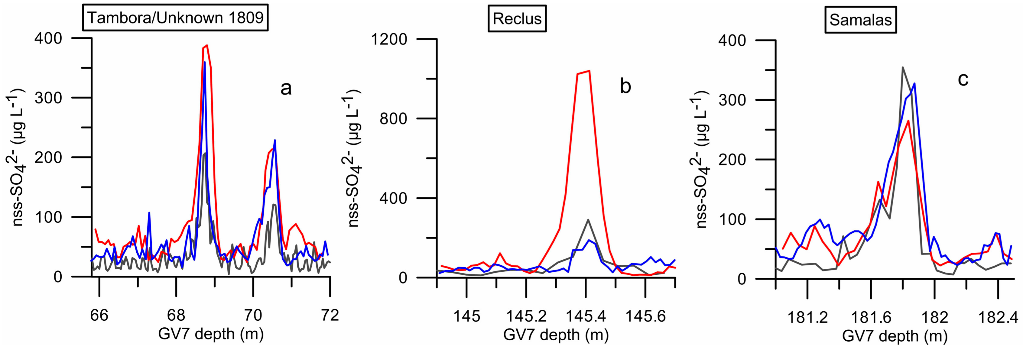
| Reclus | 145.41 | 1458 | Chile | 50°57′ S | 73°35′ W | −2 m | Pyroclastic cone |
| Samalas (Mt. Rinjani) | 181.86 | 1257 | Lombok, Indonesia | 8°24′ S | 116°24′ E | 3726 m | Stratovolcano |
| Volcanic Fluxes | ||||||||||
|---|---|---|---|---|---|---|---|---|---|---|
| Depth (m) | Volcano | 2σ | 3σ | 3MAD | GV7 ITASE | TD96 | TALDICE | GV7 | σ | VEI |
| 11.10 | Pinatubo Cerro Hudson | x | x | x | 10.46 | 4.28 | - | 5.28 | 2.88 | 6 |
| 22.12 | Agung | x | x | x | 8.15 | 5.07 | * | 5.29 | 0.61 | 4 |
| 34.01 | Unknown | x | x | 2.03 | <2 | - | 3.47 | 0.49 | ||
| 49.35 | Krakatau | x | x | 11.51 | 7.99 | 10.20 | 8.06 | 0.56 | 6 | |
| 52.17 | Unknown | x | x | <2 | - | - | 6.58 | 0.62 | ||
| 55.75 | Makian | x | x | x | <2 | 5.51 | 2.51 | 6.21 | 0.50 | 4 |
| 63.27 | Cosiguina | x | x | x | 11.90 | 6.39 | 15.55 | 0.47 | 5 | |
| 68.75 | Tambora | x | x | x | 42.31 | 34.44 | 41.12 | 0.97 | 7 | |
| 70.53 | Unknown 1809 | x | x | x | 44.46 | 38.32 | 23.32 | 1.66 | ? | |
| 73.97 | Unknown | x | x | x | 8.52 | 5.08 | 6.09 | 0.75 | ||
| 101.25 | Gamkonora | x | x | Missing data | - | 12.91 | 0.48 | 5 | ||
| 108.39 | Parker Peak | x | x | 6.43 | 8.56 | 11.14 | 0.58 | ? | ||
| 117.48 | Huaynaputina | x | x | x | 11.25 | 8.23 | 8.77 | 0.94 | 6 | |
| 139.99 | Unknown | x | x | - | 2.26 | 5.30 | 0.28 | |||
| 145.41 | Reclus | x | x | x | 119.7 | 22.66 | 28.13 | 0.42 | 6 | |
| 160.25 | Unknown | x | x | x | 16.43 | 13.27 | 12.12 | 0.69 | ||
| 166.01 | Unknown | x | x | x | 15.22 | 13.71 | 16.69 | 0.09 | ||
| 178.73 | Unknown | x | x | x | 3.55 | 41.51 | 38.84 | 0.14 | ||
| 180.03 | Unknown | x | x | 10.23 | 9.38 | 8.09 | 0.11 | |||
| 181.86 | Samalas | x | x | x | 21.72 | 121.51 | 53.36 | 1.01 | 7 | |
| 186.60 | Unknown | x | x | x | 12.68 | 23.06 | 10.98 | 0.67 | ||
| 188.03 | Unknown | x | x | <2 | <2 | <2 | 0.40 | |||
| 193.07 | Unknown | x | x | x | 10.86 | 10.99 | 0.66 | |||
| 196.17 | Unknown | x | x | x | 8.95 | 8.15 | 0.29 | |||
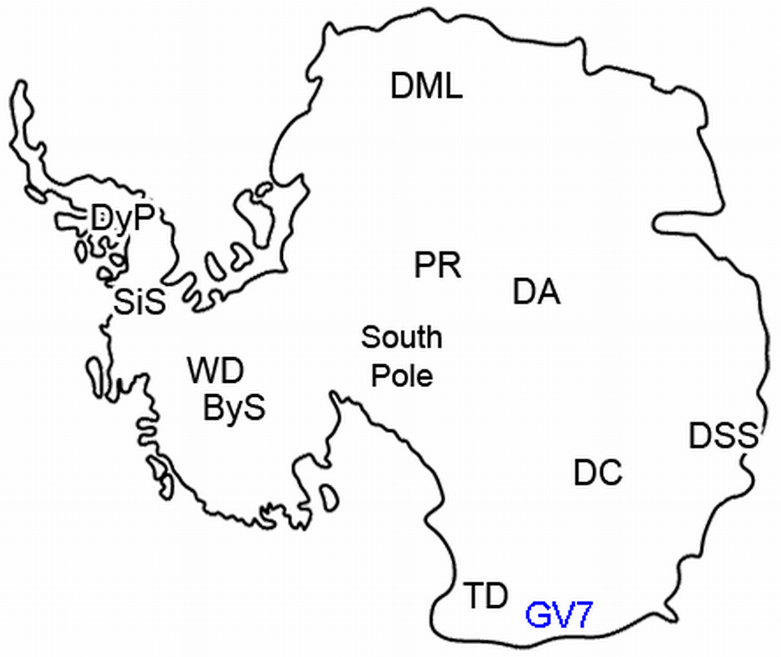
| Site | Abbr. | Position |
|---|---|---|
| Talos Dome | (TD) | 72°48′ S; 159°06′ E |
| Dome C [26] | (DC) | 75°06′ S; 123°24′ E |
| WAIS Divide [30] | (WD) | 79°47′ S; 112°09′ W |
| Dome South Summit (Law Dome) [54] | (DSS) | 66°43′ S; 112°48′ E |
| Siple Station [55] | (SiS) | 75°55′ S; 84°15′ W |
| Dyer Plateau [55] | (DyP) | 70°40′ S; 64°52′ W |
| South Pole [56] | (PS14) | 90° S; |
| South Pole [56] | (PS1) | 90° S; |
| Dronning Maud Land [29] | (DML05) | approx. 75°00′ S; 00°00′ E |
| (DML07) | approx. 75°30′ S; 04°00′ W | |
| (DML17) | approx. 75°10′ S; 07°00′ E | |
| (DML03) | approx. 74°30′ S; 03°00′ E | |
| Amundsen-Scott, South Pole [57] | (SP1) | 90° S |
| Amundsen-Scott, South Pole [58] | (SP2) | 89°57.5′ S; 17°40′ W |
| Dome A [59] | (DA) | 80°22′ S; 77°22′ E |
| Plateau Remote [60] | (PR) | 84°00′ S; 43°00′ E |
| Byrd Station [61] | (ByS) | 80°01′ S; 119°31′ W |
| GV7 | Ant. comp. | DC | WD | DSS | SiS | DyP | PS14 | PS1 | DML05 | DML07 | DML17 | DML03 | SP1 | SP2 2011 | DA 2012 | PR | ByS | ||
|---|---|---|---|---|---|---|---|---|---|---|---|---|---|---|---|---|---|---|---|
| Volcano | ƒ | ±σ | ƒ ± SD | ƒ | ƒ ± σ | ƒ ± σ | ƒ | ƒ | ƒ | ƒ | ƒ ± σ | ƒ | ƒ ± σ | ƒ ± σ | ƒ | ƒ | ƒ | ƒ | ƒ |
| Pinatubo | 5.28 | ±2.88 | 11.1 ± 1.4 | 10.7 | 25.4 ± 2.8 | 12.2 | |||||||||||||
| Cerro Hudson | 19.1 ± 0.8 | 17.3 ± 7.9 | 11.9 ± 2.5 | 19.1 ± 5.9 | |||||||||||||||
| Agung | 5.29 | ±0.61 | 11.5 ± 1.4 | 8.4 | 16.5 ± 2.8 | 10.1 ± 0.5 | 33 | 13 | 9.1 | 10.7 ± 2.9 | 9.6 ± 3.7 | 5.1 ± 7.3 | 11.2 | 14.97 | 6.68 | 7 | |||
| Krakatau | 8.06 | ±0.62 | 10.4 ± 2.0 | 9.3 | 11.2 ± 2.6 | 16.8 ± 0.7 | 17 | 11 | 8.2 | 9.4 | 9.7 ± 2.5 | 12.4 ± 2.7 | 5.5 ± 1.9 | 5.6 ± 2.9 | 12.9 | 9.03 | 9.42 | 14 | |
| Makian | 6.21 | ±0.50 | 4.1 | 7.1 ± 2.3 | 4.4 | ||||||||||||||
| Cosiguina | 15.55 | ±0.47 | 9.6 ± 1.1 | 15.1 ± 2.5 | 8.7 ± 0.5 | 26 | 33 | 9.2 | 12.2 | 5.4 ± 4.3 | 11.1 ± 3.6 | 4.3 ± 3.7 | 7.8 ± 5.6 | 9.72 | 6.9 | 6.57 | 6.31 | ||
| Tambora | 41.12 | ±0.97 | 45 ± 5.3 | 39.3 | 88.6 ± 2.2 | 57.2 ± 1.5 | 133 | 90 | 72.3 | 67.6 | 32.5 ± 7.0 | 54.6 ± 5.5 | 49.8 ± 7.1 | 47.3 ± 7.7 | 64.01 | 26.3 | 17.84 | 22.39 | 24 |
| Unknown 1809 | 23.32 | ±1.66 | 25.4 ± 3.0 | 10.2 | 33.8 ± 1.8 | 24.6 ± 1.3 | 54 | 54 | 29.8 | 32 | 15.4 ± 8.3 | 27.5 ± 3.4 | 24.6 ± 3.2 | 35.8 ± 7.0 | 28.04 | 23.1 | 12.04 | 8.3 | 11 |
| Gamkonora | 12.91 | ±0.48 | 8.1 ± 0.9 | 5.3 | 11.5 ± 3.6 | 14.7 ± 0.5 | 19 | 22 | 7.4 ± 5.2 | 3.5 ± 1.9 | 3.34 | 5.55 | |||||||
| Parker Peak | 11.14 | ±0.58 | 14.9 ± 1.7 | 12.4 ± 2.3 | 21.3 ± 0.8 | 34 | 13 | 15.1 ± 3.9 | 12.1 ± 6.6 | 19.88 | 5.67 | 7.06 | 8 | ||||||
| Huaynaputina | 8.77 | ±0.94 | 18.7 ± 2.6 | 13.4 | 24.0 ± 4.0 | 34 | 30 | 22.5 | 11.5 ± 9.0 | 24.8 ± 6.8 | 22.98 | 16.9 | 11.6 | 4.91 | 11 | ||||
| Reclus | 28.13 | ±0.42 | 63.6 ± 7.4 | 31.7 | 103.8 ± 4.1 | 106.3 ± 4.0 | 122 | 74 | 47 ± 7.5 | 38.1 ± 6.8 | 65.55 | 75.2 | 36.23 | 133.37 | 38 | ||||
| Samalas | 53.36 | ±1.01 | 73.4 ± 8.7 | 20.5 | 79.7 ± 2.8 | 101.1 ± 4.3 | 135.7 | 74.3 ± 6.0 | 58.5 ± 10.3 | 179.45 | 99.3 | 63.27 | 46.3 | 54 | |||||
© 2020 by the authors. Licensee MDPI, Basel, Switzerland. This article is an open access article distributed under the terms and conditions of the Creative Commons Attribution (CC BY) license (http://creativecommons.org/licenses/by/4.0/).
Share and Cite
Nardin, R.; Amore, A.; Becagli, S.; Caiazzo, L.; Frezzotti, M.; Severi, M.; Stenni, B.; Traversi, R. Volcanic Fluxes Over the Last Millennium as Recorded in the Gv7 Ice Core (Northern Victoria Land, Antarctica). Geosciences 2020, 10, 38. https://doi.org/10.3390/geosciences10010038
Nardin R, Amore A, Becagli S, Caiazzo L, Frezzotti M, Severi M, Stenni B, Traversi R. Volcanic Fluxes Over the Last Millennium as Recorded in the Gv7 Ice Core (Northern Victoria Land, Antarctica). Geosciences. 2020; 10(1):38. https://doi.org/10.3390/geosciences10010038
Chicago/Turabian StyleNardin, Raffaello, Alessandra Amore, Silvia Becagli, Laura Caiazzo, Massimo Frezzotti, Mirko Severi, Barbara Stenni, and Rita Traversi. 2020. "Volcanic Fluxes Over the Last Millennium as Recorded in the Gv7 Ice Core (Northern Victoria Land, Antarctica)" Geosciences 10, no. 1: 38. https://doi.org/10.3390/geosciences10010038