
Coastal Dune Restoration: A Checklist Approach to Site Selection

1
Department of Environmental Sciences, Informatics and Statistics, Ca’ Foscari University of Venice, Via Torino 155, 30172 Venice, Italy
2
Department of Biological, Geological and Environmental Sciences, University of Bologna, Via Irnerio 42, 40126 Bologna, Italy
*
Author to whom correspondence should be addressed.
Land 2024, 13(2), 135; https://doi.org/10.3390/land13020135
Submission received: 28 December 2023
/
Revised: 19 January 2024
/
Accepted: 23 January 2024
/
Published: 25 January 2024
(This article belongs to the Special Issue Mediterranean Marine-Coastal Ecosystems: Changes and Dynamics)
Abstract
:Coastal dune systems around the world have been severely degraded by human activities, especially in the last century. This has resulted in severe structural and functional damage to these dynamic yet fragile transitional ecosystems and a net loss of important ecosystem services, especially in the face of climate change threats. The implementation of measures for sustainable coastal management and the restoration of degraded ecosystems are urgently needed. In this context, we revised and used several indicators and indices on the geomorphology, biology, and ecology of the dune systems along the Venetian coast to define the current conservation status and assess the feasibility of dune restoration measures. The application of the indices provided important information about the sites and the measures needed to improve the functionality of the coastal dune systems. In addition, the indices provided useful insights for the implementation of management strategies aimed at ensuring the current and future provision of ecosystem services by coastal dune systems and promoting their sustainable use by translating scientific knowledge into management and restoration practices, which has been a bottleneck in ecosystem conservation and restoration so far.
1. Introduction
Coastal dune ecosystems are fragile environments that nevertheless provide crucial ecosystem services, acting for example, as a key element of defence for nearby inland areas by dissipating wave energy, retaining sediments, and preventing flooding [1,2].
The dynamics of coastal dune systems are largely influenced by the interaction between natural drivers and human activities, two factors that are strongly interdependent but often in conflict with each other [3]. The size of a sandy dune system depends on the availability of sediments, the width of the upper beach, the prevailing winds, and the presence of engineer plant species that favour the deposition and consolidation of sandy substrates [4,5,6]. Winter storm surges are major drivers in shaping coastal geomorphology, and the capacity of dune systems to withstand high-energy events and serve as protective barriers lies in their natural ability to adjust to natural disturbances and recover by changing their configuration in terms of both shape and position [7]. However, the geomorphological response of beaches and dunes during a storm depends on several factors, including storm-related features [8], environmental variables such as tide and wind direction [9], and geomorphological factors such as the type of sediment [10], dune height [11], beach and dune width and slope [12], and the volume of sand deposited on the beach and dunes [13].
Therefore, when dunes are damaged or destroyed, their capability to protect nearby inland areas is lost, with both ecological and socio-economic consequences. In the Mediterranean in particular, dune systems have been largely replaced with facilities designed to accommodate tourists during the summer months [14,15]. Increasing urban development and supporting infrastructure, massive beach tourism, and beach management activities (e.g., mechanical grooming) have resulted in highly altered morphology, beach flattening, removal of dunes, and decreased vegetation cover. As a result, not only has coastal biodiversity been severely degraded, but this has ultimately led to the loss of ecosystem services, including the protection of coastal areas, exposing coastal areas to environmental hazards [16]. The loss and degradation of coastal dune systems, combined with the loss of the services they provide, makes the restoration of the remaining coastal systems urgent not only for mitigating current natural stressors but also for coping with future threats from climate change impacts [17,18].
So far, to manage coastal erosion and increase inland protection against storm impact, defence techniques have primarily included grey engineering structures (e.g., seawalls, jetties, and groins) [19,20]. However, coastal armouring has substantial ecological impacts [21,22] and high economic costs (e.g., [23]) while often failing to achieve the expected results, being unable to follow natural coastal dynamics [24,25]. Measures such as beach nourishment have been partially successful in mitigating coastal erosion, but they are short-term solutions that need to be repeated over time [26,27,28,29]. Recently, approaches to the mitigation of the effects of coastal flooding are moving towards environmentally targeted solutions as they are considered less expensive, more robust, and sustainable, as well as applicable to a range of spatial scales [30]. In this regard, an increasingly adopted Nature-based solution to mitigate threats posed by climate change is the restoration of coastal dune systems [31] since it enables the recovery of natural processes and ecosystem functioning, thereby improving both their ecological and utilitarian functions [32,33].
Although Nature-based solutions globally emerged as a noteworthy pathway for delivering transformative change in sustainable management, and their benefits are increasingly being recognised [34], their concrete adoption is often prevented by several socio-economic, political, and environmental constraints [35].
When considering coastal dune restoration actions, two main issues have to be considered. The first issue regards the selection of sites where restoration actions are most needed, which depends on the geomorphological and ecological conditions of the beach-dune systems. The second issue mostly pertains to the socio-economic context: because of their interconnected social–ecological nature [35], sand dune ecosystems are embedded in diverse socio-economic contexts with a variety of uses and users with often conflicting interests.
Considering the two points above, planning and implementing Nature-based solution projects requires a throughout understanding not only of the geomorphological, climatic, and ecological characteristics of a site but also of uses and management practices [36,37]. This is especially crucial on urban developed coasts where coastal dunes and beaches are mostly managed for recreational purposes, raising the need to solve conflicts between socio-economic interests and nature restoration.
Recently, two studies addressed the issue of selecting coastal sites suitable for dune restoration by developing indices and using the checklist approach (i.e., [38,39]). They showed that the checklist approach is a relatively simple and reliable method for describing the status of coastal dunes and highlighting threatened sites [39]. These studies took the current conservation status of coastal dunes as a starting point to determine the need for conservation or restoration. However, there is little information on the actual potential and management compatibility of a site for a healthy dune system. This lack of information prevents a more comprehensive assessment of the sustainability of restoration measures and the need to improve management.
In light of these considerations, the aim of this study was to develop and test an index of “dune restoration potential” able to combine the measurement of variables key to the formation and persistence of dune systems with the effects of the impact of human use and management to support the decision-making process and promote the transition towards sustainable use without compromising the local economy.
2. Materials and Methods
2.1. Study Area
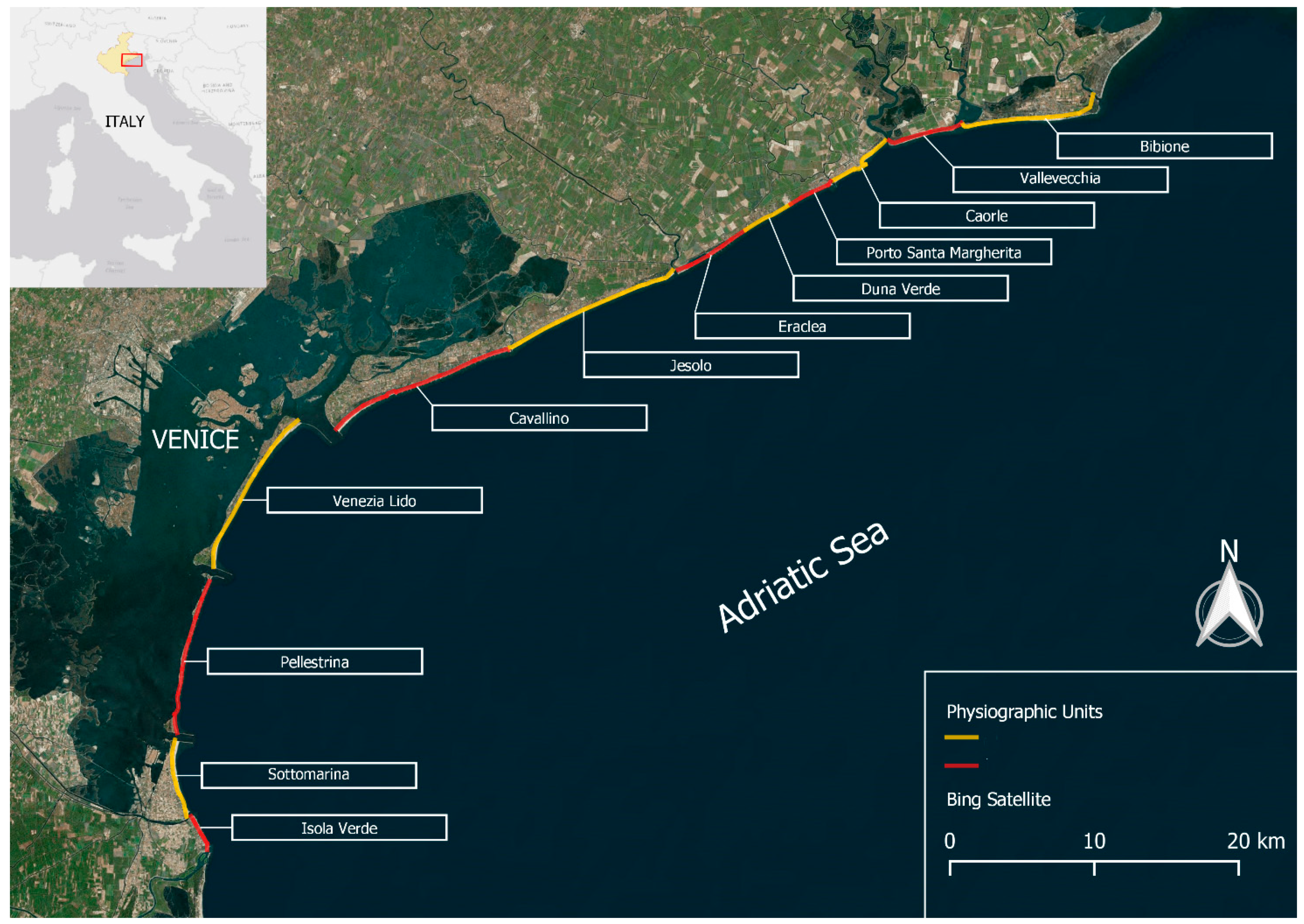
The study area corresponds to the Venetian portion of the north Adriatic coast (north-eastern Italy), delimited by the estuaries of the Adige (in the south), and Tagliamento (in the north) rivers, for a total length of approximately 92 km (Figure 1).
The area presents a temperate macro-bioclimate, with an average temperature of 14.4 °C and rainfall of 1090 mm per year [40]. Prevailing winds are from the north-eastern (the “Bora” blowing in winter) and south-eastern (the Scirocco blowing in summer) directions [41], with an average wind speed of 3.1 m/s, which causes typically bimodal wave movements, with a significant wave height of about 0.47 m on an annual average [19]. The tidal regime is of a semi-diurnal and microtidal nature, with an average excursion of 70 cm and an anti-clockwise circulation characteristic of the Adriatic basin [42]. Sediments are made up of well-classified sandy Quaternary deposits with a high carbonate content [43].
Figure 1.
The Venetian coast with the 12 physiografic units defined by Fontolan et al. [43].
Figure 1.
The Venetian coast with the 12 physiografic units defined by Fontolan et al. [43].

Until the 1950s, the Venetian coast was almost entirely fronted by dunes up to 10 m high [44], but few of these still survive. Starting from the 1960s, coastal dynamics have been modified by the construction of grey engineering structures (e.g., seawalls, jetties, and groins), that now occur on more than 60% of the coastline. Beach nourishment has become a consolidated practice to support the local economy [45].
Nowadays, the coastline suffers from heavy human use. Summer beach tourism is one of the main resources of the region, with an average of more than 24 million tourist stays every year [46]. Most sites are managed by private corporations, and land lying behind the beaches has been mostly developed as campsites, resorts, towns, and villages [47]. According to Ariza et al. [48], study sites can be classified as urban coastal dunes (with at least 60% of urbanised hinterland) or urbanised coastal dunes (with a maximum of 50% of urbanised hinterland). Natural coastal dunes (up to a maximum of 30% of urbanised hinterland) only cover a coastal stretch of 34 km [43] and are protected under the Habitats Directive 92/43/EEC.
The study area is part of a large-scale restoration project carried out in the framework of a European LIFE project (LIFE16 IT/NAT/000589 REDUNE) [49].
2.2. Data Collection
To assess the suitability of sites for restoration, we carried out detailed preliminary characterisation of both the abiotic and biotic components of the dune systems, as well as human activities and management practices. The assessment was carried out using the “checklist method” [37,38,39,50,51], namely, a systematic procedure for data collection based on the measurement of variables key to the formation and persistence of dune systems. The variables include the dune system geomorphology, aeolian and marine processes, biological characteristics, and dune system management. In order to quantify the variables, we first divided the Venetian coast into 12 physiographic units defined by Fontolan et al. [43], which are geographically differentiated by the presence of sections such as estuaries and tidal inlets (Figure 1). Subsequently, each unit was further subdivided into sectors (littoral cells) that are homogeneous in terms of hydrodynamics, sedimentation, and morphological structure [43]. As a result, we defined 65 sectors, each corresponding to one site (Figure S1) and the proposed assessment procedure was applied to each site.
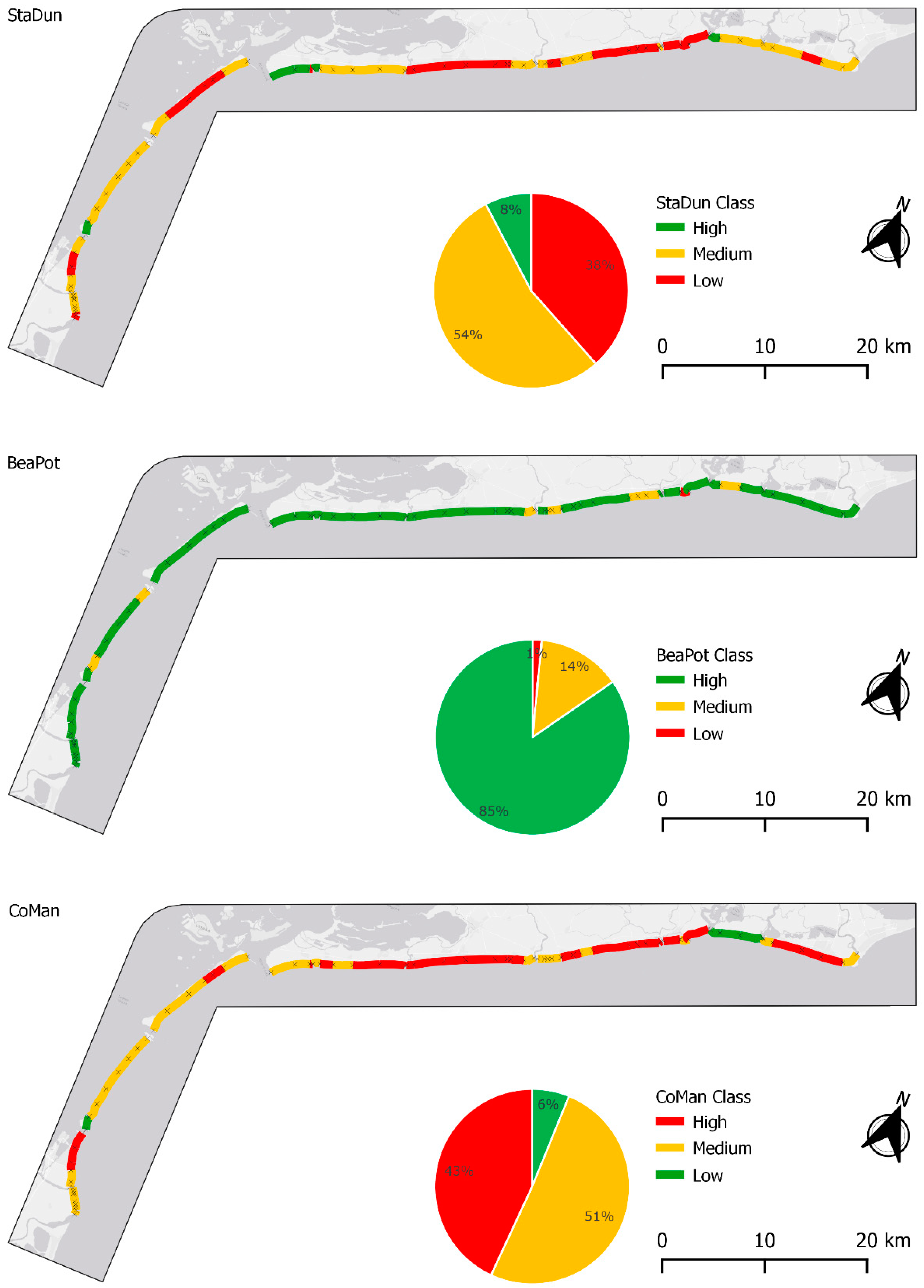
The selected variables were used as indicators following Garcia-Lozano et al. [39] and purposely revised to adapt them to the Mediterranean region and urban and urbanised coasts (the modified indicators are listed in Table S1). Overall, the set of indicators (Table 1) takes into account geomorphological features, meteo-hydrological and marine conditions, biological and ecological characteristics, and use/management practices. By properly combining the indicators in partial indices, they allowed us to define (i) the current conservation status of the dune system (StaDun), (ii) the potential of a given stretch of beach to host a dune system (BeaPot), and (iii) the impact of management practices (CoMan).
2.2.1. Geomorphological and Ecological Status of Dunes (StaDun)
The geomorphological and ecological status of dunes (StaDun) was derived based on indicators 1–11 (Table 1). Indicators 1–7 address the morphology of the dunes (e.g., type, structure, height, extent) and their evolution over time. Indicators 8–11 address the status of the existing plant communities by assessing species composition in terms of typical sand dune species (species that are resistant to sand burial and can promote the formation of dune systems, i.e., “Type III species” according to García-Mora et al. [51]), native and focal species, invasive alien species, and ruderal species. Geomorphological and topographical indicators were quantified using digital orthophotos, satellite images, and digital terrain models, while plant communities were assessed using a geo-referenced database of 1078 plots and 208 species. The georeferenced database included plots surveyed between 2010 and 2021 by the plant ecology research team of Ca’ Foscari University of Venice along the dune systems on the Venetian coast and by Filesi et al. [57]. Type III species were derived from García-Mora et al. [51], native and focal species of the Adriatic dune systems were defined according to Acosta and Ercole [54], alien species according to Galasso et al. [55], and ruderal species according to Del Vecchio et al. [56]. Details on the measurements can be found in Supplementary S1 (Table S2).
2.2.2. Beach Potential to Host Dunes (BeaPot)
The potential of a beach to host dunes (BeaPot) was derived based on indicators (Table 1) describing the morphodynamic state in terms of erosion or accretion (e.g., beach profile, recent shoreline evolution, sediment budget), as well as other factors such as slope and width of the upper beach, wind intensity, and sediment sorting. The indicators were measured using orthophotos, digital terrain models, the literature, or databases and can be found in Supplementary S1 (Table S3).
2.2.3. Management of the Beach–Dune System (CoMan)
The management of the beach–dune system (CoMan) was derived from indicators related to (a) the pressure exerted on the system by tourists and tourist facilities (indicators 1, 7, and 8 in Table 1); (b) management measures to limit the impact on the existing dune systems (indicators 2, 3, 4, and 9); (c) management measures potentially affecting the sediment balance and natural dynamics of the system (indicator 6); and (d) active measures aimed at promoting the development of the dune system through sediment accumulation (indicator 5). The measurements were determined based on field trips, communication with local managers, the literature, and photo interpretation as reported in Supplementary S1 (Table S4).
2.3. Data Analysis
The measurement of each indicator was standardised by scoring the values on a scale from 0 to 4 (Table 1). We then calculated a score for each partial index using the following equation:
where IS is the index score, R is the rank value of each indicator, and Rmax is the maximum rank value that an indicator can take. The IS for each index can therefore range between 0 and 1. Following Garcia-Lozano et al. [39], the IS values were then categorised as “Low”, “Medium”, and “High” for scores < 0.33, between 0.33 and 0.66, and >0.66, respectively.
IS = Σ R/Rmax
While for StaDun and BeaPot, the higher the value, the greater the conservation status of dunes or the natural potential of beach-to-dune hosting, for CoMan, this is not the same. Specifically, the higher the value of CoMan, the greater the negative impact on the beach–dune system resulting from the (lack of) management. Differently from Garcia-Lozano et al. [39], the approach used in the calculation of CoMan aims to measure the “impact level” of coastal management and to hypothesise tailored management actions that can improve and maintain a site’s ability to host a dune system over time.
The three indices, StaDun, BeaPot and CoMan, were then combined to develop two summarising indices: (a) coastal management requirement (CMR) and (b) dune establishment potential (DEP).
2.3.1. Coastal Management Requirement (CMR)
The coastal management requirement (CMR) defines the most appropriate management measures to be taken at each analysed site. It was determined as the combination of StaDun and the product between CoMan and BeaPot (cfr. DRP in Garcia-Lozano et al. [39]). The StaDun classes were derived based on the values of Equation (1), while the classes of the product of CoMan and BeaPot were defined as “Low”, “Medium”, and “High” for scores < 0.33, between 0.33 and 0.66, and >0.66, respectively. Finally, four management classes were defined (Table 2).
“Conservation” was assigned to sites with a good conservation status of the system and good management practices (i.e., low impact). “Restoration” was assigned to degraded systems that have a good chance of recovering with restoration measures and subsequently improved management practices. “Recovery” was assigned to sites where there are currently no dunes but which, if created and appropriate management practices are applied, have a chance of persisting over time. “Renaturalisation” was assigned to sites where the creation of a dune system would require a combination of hard and soft engineering interventions, as neither the physical nor management characteristics would allow natural development.
2.3.2. Dune Establishment Potential (DEP)
The dune establishment potential (DEP) defines the possibility of a site to increase its potential to host a dune system. It was calculated as the combination of the potential to host a dune system (BeaPot) and the human impact (CoMan) according to the following formula:
DEP = BeaPot − CoMan
The index ranges from −1 to +1. Positive values indicate good potential, while negative values indicate a low chance of hosting and maintaining dune systems. Negative values can result not only from inadequate physical characteristics (e.g., scarce sediment supply, high erosion) but also from a lack of (or inappropriate) management. Indeed, high CoMan values can outweigh the natural potential of a beach to host and maintain a dune system.
The DEP values were categorised into three classes as follows: “Low” for negative values, “Medium” for values between 0 and +0.33, and “High: for values > 0.33. The “Low” class indicates that the physical potential of the beach is overwhelmed by very impactful management practices that prevent the formation and development of a dune system. The “Medium” class indicates that the physical characteristics of the beach are almost offset by the negative effects of management activities and that the formation and development of a dune system may be hindered. The “High” class indicates that the management measures would allow the coexistence of tourism and the dune system.
2.3.3. Management Improvement Simulation
While the CMR index reveals the management strategy to be applied without any indications of the possible activities to be adopted, DEP allows for simulating which (set of) actions may be useful to enhance the establishment of a dune system. To identify which management actions can improve the potential of a beach to host a dune system, DEP values were calculated using simulated CoMan values obtained by gradually shifting the CoMan score towards the lower impact class. Specifically, the score of CoMan indicators 3–9 (Table 1) was shifted by one or two classes to simulate a lower impact achieved by improved management actions. Changes were made from the simplest and least costly to the most demanding management actions. The “low effort” actions included management of paths, installation of sand traps, or regulation of the frequency of mechanical cleaning (CoMan 3, 5, and 6). The “medium effort” actions, i.e., changes in management actions that are more challenging to modify from a practical point of view because they require high initial investment, included fencing the dunes or reducing the extent of cover by permanent or temporary structures on the dune beach system (CoMan 4, 7, and 8). The “high effort” actions, i.e., actions with higher costs and continuity over the years, included active surveillance of dune systems (CoMan 9). Changes in indicators related to tourism pressure (CoMan 1) were not considered as the aim was to assess the improvement in a site’s suitability as a location for a dune system without affecting tourism activities and the economic source of income on the coast. The installation of an information board (CoMan 2) was also not considered as their contribution to increased effectiveness and sustainability of restoration activities is more subtle and difficult to determine.
To obtain an overview of the potential impact of improving management actions, we considered 35 different scenarios (Table S6) given by different combinations of management changes (Table S5) and compared the improvement in terms of number of low DEP sites to the current state of the Venetian coast. Particularly, we identified the least management (set of) changes that can improve the low-potential sites to medium-potential by 25%, 50%, and 75% and the management actions that can improve DEP at the highest number of low-potential sites (“best simulation”).
Finally, to examine the effect of the scenarios on DEP, 9 sectors were randomly selected along the Venetian coast, 3 for each current DEP class identified.
3. Results
3.1. Geomorphological and Ecological Status of Dunes (StaDun)
Most sites (60%) were categorised as “Medium” (values between 0.33 and 0.66) and covered about 53 km of the Venetian coast (Table S7; Figure 2), mainly due to the “Maximum height of the foredune” and “Incipient morphologies on the dune face”, which was limited at many sites. Other indicators that influenced the state of the dune systems were related to the plant communities, i.e., the scarce presence of “Type III species on the dune front” and the significant presence of “Alien species”. Twenty-five sites belonged to the “Low” class (score < 0.33), which amounts to almost 40% of the coastline. Most of these sites were characterised by the absence of a true dune system, a limited dune height, the absence of incipient forms, and a limited number of species typical of coastal dunes.
3.2. Beach Potential to Host Dunes (BeaPot)
The analysis of the potential of the beaches to host a dune system showed that more than 80% of the sites, covering more than 72 km of the Venetian coast (Table S7; Figure 2), had characteristics that would guarantee a high potential. Almost all sites had high values for “Slope of the beach”, due to the gentle slope of most sites, as well as for “Significant wave height”, “Diameter of the sediment”, and the percentage of “Sand < 0.5 mm” (a characteristic that applies to the entire Venetian coast). The indicators that had the greatest impact on the potential for dune restoration were associated with the slope and width of the beach.
3.3. Conservation Actions and Management of the Beach–Dune System (CoMan)
According to the CoMan indicators, more than 40% of the surveyed sectors, covering half of the total length of the Venetian coast, were categorised in the highest impact class (Table S7; Figure 2). The “touristic use pressure” showed high impact values for many sites, while “Information boards” and “Sand traps” were absent at most sites. The lack of fencing (“Dune area with restricted access”) and the high frequency (daily) of “Mechanical cleaning/levelling the beach in high season” also had a strong impact. The indicator “Protection of the system and the immediate environment” had the highest impact value at all sites. This emphasises the lack of active protection as a common impact across the Venetian coast. Approximately 50% of the sites were categorised as “Medium”. The lower impact was mainly related to lower “Touristic use pressure” and the presence of effective or unnecessary “Sand traps”. Other aspects that led to a lower impact were the lower presence of temporary and permanent structures on the entire dune beach system.
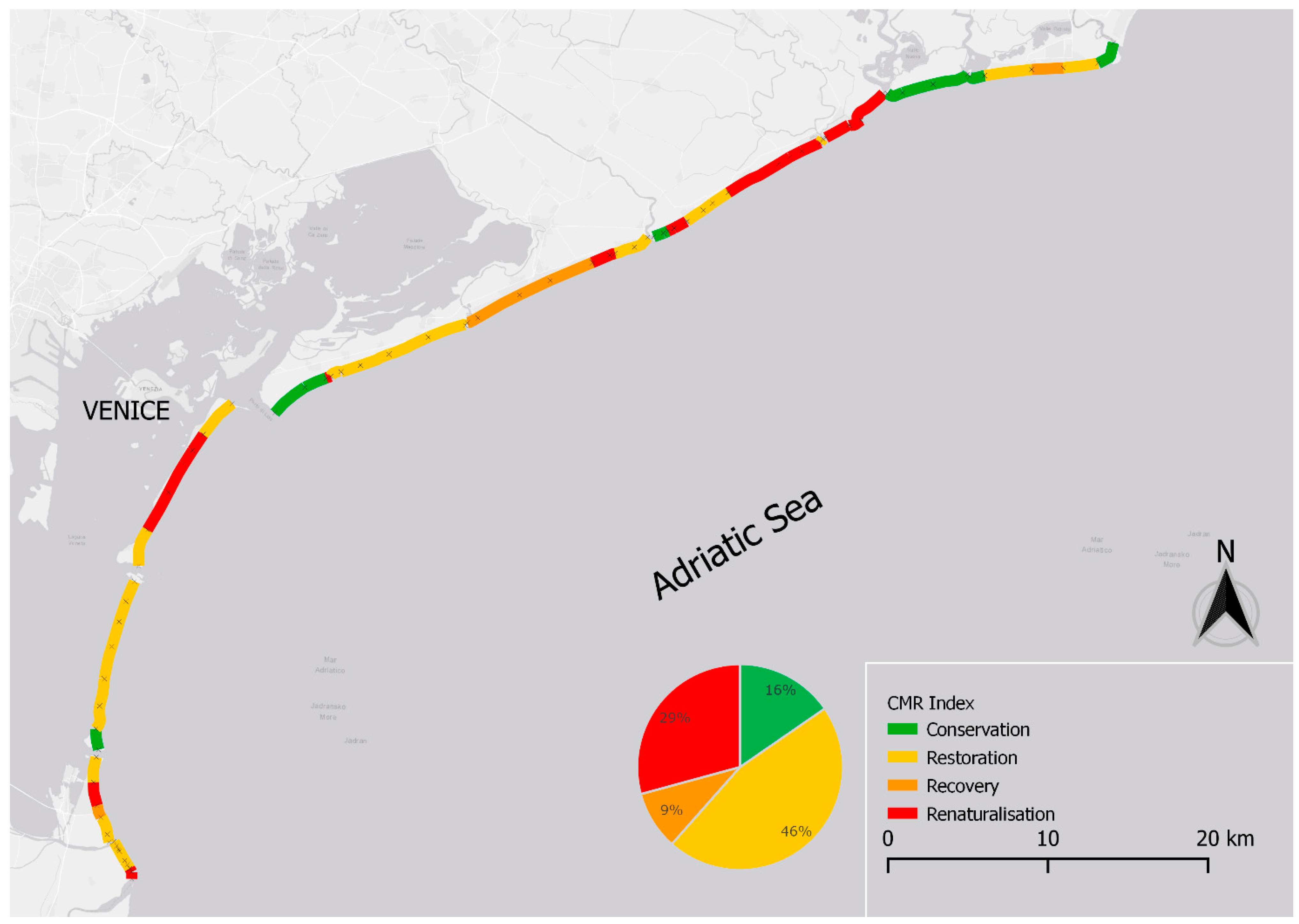
3.4. Coastal Management Requirement (CMR)
The CMR index showed considerable differences in the measures to be taken along the Venetian coast (Table S7; Figure 3 and Figure S2). Only 10 sites had geomorphological, physical, biological, and management characteristics that met the requirements of the best category, i.e., “Conservation”. The sites considered here either already had a dune system in a good state or the dune system had intermediate conditions (“Medium” StaDun), supported by a high natural beach potential (“High” BeaPot) and low/medium impact management (CoMan). Most sites (n = 30), covering almost half of the Venetian coast, fell into the “Restoration” category, i.e., sites where the dune system was degraded but could easily recover. The sites assigned to this category were characterised by a coastal dune system in an intermediate condition, resulting from the combination of (a) beaches with high natural potential and medium impact management; (b) a medium level of both management impact and beach potential; and (c) sites with a lack of management (i.e., high impact) compensated by a high natural potential of the existing beach. The “Recovery” category included only six sites. In this case, the sites were characterised by the absence of a dune system and by impactful management combined with the high natural potential of the beach. At these sites, the coastal dunes could be recovered thanks to the good physical and morphological characteristics of the beach, provided that management was improved. The “Renaturalisation” category comprised 19 sites where restoration of the beach–dune system would require a combination of hard and soft engineering interventions. All sites in this category were characterised by the absence or poor condition of the dune system combined with very or moderately impactful management. Some sites fell into this category because they had intermediate potential values and high- or medium-impact management.
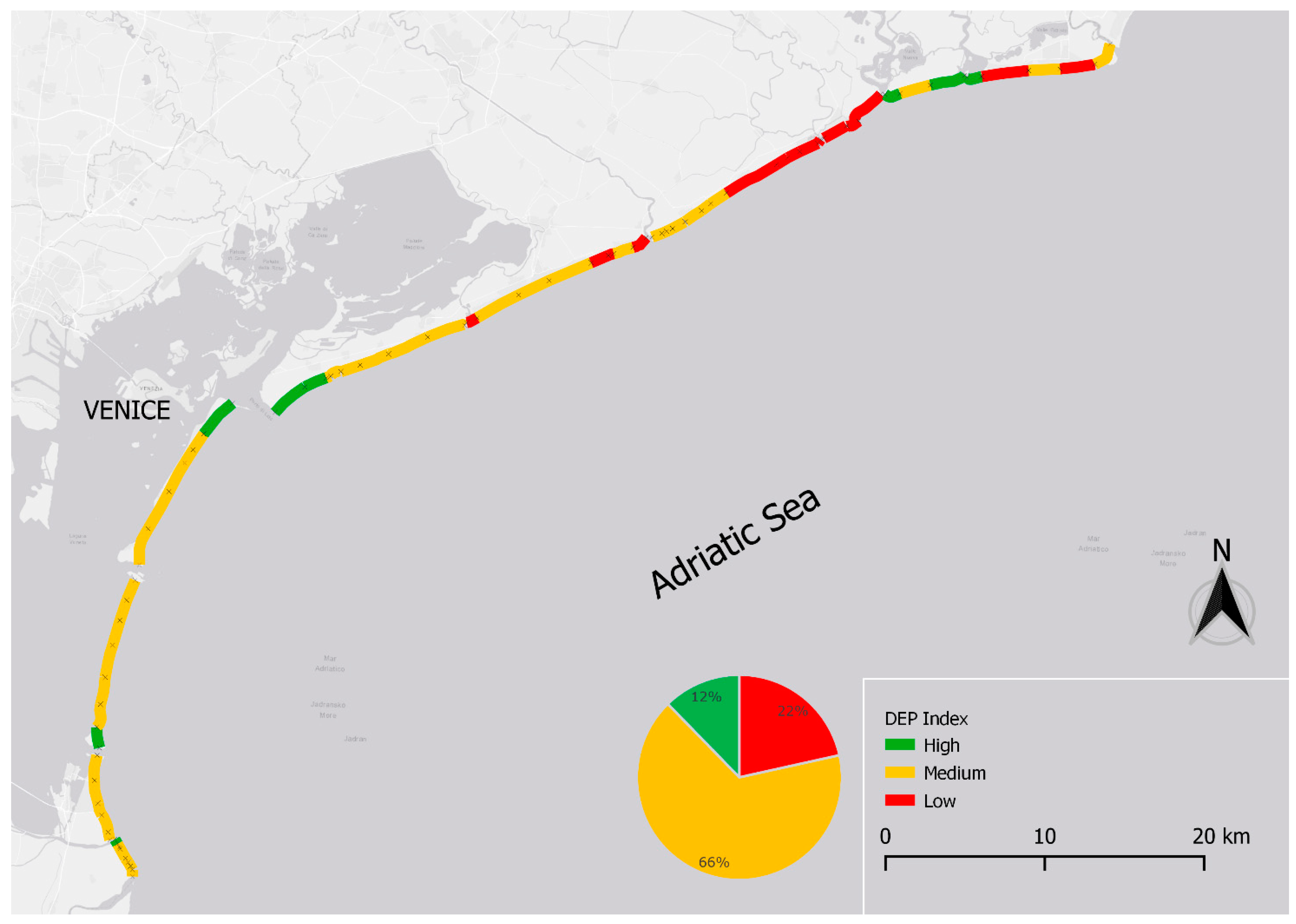
3.5. Dune Establishment Potential (DEP)
Approximately 12% of the sites (n = 8) had suitable physical and management conditions for the formation and maintenance of a dune system (Table S7; Figure 4 and Figure S3). The high DEP value was mainly due to the presence of accretionary and well-developed beaches, granulometric characteristics, and the presence of low-impact management, such as limited frequency of beach cleaning. Most sites (n = 43, about 66% of the Venetian coast) were categorised as “Medium”. At these sites, the overall good or medium physical potential for a dune system was largely limited by impacts due to inappropriate management, such as the lack of access restrictions to the coastal dunes, strong tourist pressure and the high frequency of mechanical beach cleaning. Only one site fell into this category, despite very good management, due to the actual limited beach potential combined with the erosion trend of the area. The “Low” class (negative values) comprised 14 sites where the beach potential for dunes was almost completely thwarted by the lack of management. These sites were characterised by very impactful management, mainly due to a lack of access restrictions to the dunes, strong tourist pressure, a high frequency of beach cleaning, and a high proportion of temporary structures in the beach–dune system. Only one site had a low DEP value due to the lack of natural potential of the beach.
3.6. Management Improvement Simulation
All the 35 considered scenarios improved the low DEP sites of the Venetian coast (Tables S8.1–S8.3). Specifically, 12 out of 35 scenarios improved the 14 low-potential sites by 25–50% compared with the current state; 5 scenarios led to an improvement of 50–75% of low-potential sites; and 18 scenarios provided an improvement of more than 75% of the current low-potential sites. Globally, scenario #31 was revealed to be the “best simulation” by improving 93% of low DEP sites to medium DEP.
As illustrated in Table 3, a greater number of improved low-potential sites was reached with a small number of actions (namely, one or two), but better results required more expensive actions (namely, “medium”- and “high”-effort measures). On the other hand, improvement can also result from the combination of many “low effort” actions (Table 4).
However, the same set of actions could result in different degrees of improvement, also in sectors that fell under the same CMR class (Table 5).
4. Discussion
The European Union has committed to an ambitious biodiversity recovery plan in the Biodiversity Strategy for 2030 and the Nature Restoration Law, which aims to halt biodiversity loss and move towards sustainable development, with a focus on restoring degraded habitats, expanding the network of protected areas, and improving the effectiveness of management, governance, and financing. In this study, we presented an approach developed within the LIFE REDUNE project (LIFE16 NAT/IT/000589 Restoration of dune habitats in Natura 2000 sites of the Veneto coast) [49] to plan Nature-based dune restoration measures on urban or urbanised coasts, taking into account the current state of dune systems and their restoration potential.
The approach we used is based on the application of a set of indices that consider different aspects of the vulnerability, conservation, and restoration potential of dunes. These aspects include the geomorphology of the dune system, aeolian and marine processes, biological features, and management of the dune system (e.g., [37,38]). Integrated together, the partial indices used in this study were effective in depicting an overall picture of the state of the systems, their potential weaknesses, and an assessment of the degree of restoration required. Furthermore, they provided clear indications of the actions that need to be taken at each site and thus also proved to be effective in terms of their potential to facilitate informed decision-making. Indeed, the planning and implementation of Nature-based solution projects requires a thorough understanding not only of the environmental and ecological characteristics of a site but also of its use and management practices [36,37]. This is particularly important on urban and urbanised coasts, where coastal dunes and beaches are mostly managed for recreational purposes, meaning that conflicts between socio-economic interests and nature restoration need to be resolved.
In addition, our standard procedure allowed for a comparison between different sites, thereby proving to be highly replicable, allowing for the restoration needs of dune systems to be identified on a large geographical scale. Applying this approach at different sites can significantly help to maximise the success of restoration and maintain the restored systems in a good state of conservation in the long term. This could apply beyond the costs in the Mediterranean region and be transferred to other global systems, perhaps after changing certain value ranges (e.g., dune crest height for dunes that tend to grow to a different height than in the Mediterranean region).
The analysis of the geomorphological and ecological characteristics of the studied dunes (StaDun) has shown that most of the sites along the Venetian coast are not in good conservation status, mostly due to the intensive urbanisation of the coastal areas, which has led to a major loss of coastal dune habitats and the fragmentation of the remaining parts [44,58]. Well-developed dune systems are only found in marginal areas where tourism development has been lower or where tourism is regulated by the management authority.
The most critical aspects that emerged as affecting coastal dunes were the scarce presence of incipient dunes, the low height of the foredunes, the absence of typical dune species that promote the formation of dune systems (Type III species, sensu García-Mora et al. [51]), and the presence of invasive alien plants. In particular, the low height of the foredune and the sparse presence of incipient forms indicate low sediment accumulation [19,59]. Low sand accumulation may be the result of reduced beach width or coastal erosion, which may be exacerbated by the absence of Type III species, as these are responsible for trapping and consolidating sediments [53,60]. The efficiency of the dune system can also be affected by the presence of invasive alien species, which have been shown to disrupt dune plant communities and their functionality [47,61,62].
Interestingly, the physical characteristics of the beaches (BeaPot), such as the granulometry of the sediments, the wind intensity and direction, and the meteo-marine climate, were ideal for the development of coastal dunes at most of the studied sites. Only a few sites had adverse conditions for the formation and persistence of dunes.
The most crucial issue raised by our results concerns management, which is directly related to the current state of conservation of the dune system and significantly limits the potential of the beach to harbour dune systems. Indeed, inappropriate management of coastal dunes, such as frequent mechanical beach cleaning, unregulated access to the beach, or unfenced dunes, may affect the development of incipient dunes or the availability of sediment [63,64,65]. Beach cleaning, which is usually carried out with heavy equipment, involves the complete removal of incipient dunes, levelling the beach, and sometimes also removing the foredunes if the intervention is too invasive [66]. In addition, the removal of stranded material traps a large amount of sediment, which is generally relocated outside the beach–dune system, resulting in a loss in the sediment budget [63,67].
The lack of management is also related to the uncontrolled trampling of dunes, which is one of the main causes of plant community destruction and homogenisation (e.g., [40,62,68,69]). Human trampling can directly damage plant species [40,70,71] and can also favour the establishment and spread of alien species by altering the physical and chemical conditions of the dunes [47,72,73,74] or by increasing propagule pressure, as tourists may inadvertently carry seeds on their clothing [75,76].
The strong economic development that the Venetian coast has undergone in recent decades has meant that management actions have been implemented to maximise only one of the many ecosystem services that coastal environments can provide, namely, recreational services [58,64], while other important ecosystem services such as protection against erosion and flooding have been neglected [19,65]. In a context where climate change is becoming an increasing concern for coastal areas, mainly due to sea level rise and more frequent and intense storm surges, it is essential to consider coastal dunes as a key element of the landscape and to plan coastal management in a way that maximises the capacity of dune systems to counteract the negative effects of climate change. This is certainly the case for the Venetian coast, where the effects of climate change are exacerbated by the subsidence of the area [77,78].
The analysis of potential management actions that can be implemented at specific sites proposed in our research represents a valuable tool for ecosystem restoration, as it allows for the planning of management actions aimed at restoring multiple ecosystem services. In addition, the screening of possible management actions is fundamental for the selection of appropriate management, which allows for the coexistence of human activities and natural processes.
The results that emerged from different simulations made it clear, however, that it is not possible to apply the same solution to all sectors, even within the same physiographic unit. While it is true that many management actions need to be modified to improve the potential of sites for dune systems, it is not always the case that the same set and number of actions are required to improve the condition of sites that already have a good real potential. Furthermore, it is not possible to apply the same actions to sites that have a similar rating, as the same current condition may be associated with different combinations of practices applied.
5. Conclusions
Tailored analyses of dune systems and the selection of site-specific measures are not only necessary but also potentially more sustainable, both ecologically and economically, to achieve successful restoration and sustainable use of coastal areas. Our approach allowed us not only to show what particular actions are needed to achieve restoration goals, with different actions needed at coastal sites with different characteristics but also to do so in a comprehensive and comparative way, making this an approach that can inform local stakeholders and translate scientific knowledge into practice, which has been a bottleneck in ecosystem conservation and restoration so far.
Supplementary Materials
The following supporting information can be downloaded at: https://www.mdpi.com/article/10.3390/land13020135/s1, Supplementary S1: Supporting information on indices’ calculation. Supplementary S2: Indices’ results and simulation outputs. References [79,80,81,82,83,84,85] are cited in the Supplementary Materials.
Author Contributions
Conceptualisation, A.D.B. and G.B.; methodology, A.D.B., G.B. and S.D.V.; formal analysis, A.D.B.; writing—original draft preparation, E.F., A.D.B., G.B. and S.D.V. All authors have read and agreed to the published version of the manuscript.
Funding
This research was funded by LIFE16 IT/NAT/000589 Redune.
Data Availability Statement
The raw data supporting the conclusions of this article will be made available by the authors on request. The data are not publicly available due to privacy restrictions.
Conflicts of Interest
The authors declare no conflicts of interest.
References
- Johnston, K.K.; Dugan, J.E.; Hubbard, D.M.; Emery, K.A.; Grubbs, M.W. Using Dune Restoration on an Urban Beach as a Coastal Resilience Approach. Front. Mar. Sci. 2023, 10, 1187488. [Google Scholar] [CrossRef]
- Roig-Munar, F.X.; Martín-Prieto, J.Á.; Rodríguez-Perea, A.; Batista, Ó.O. Environmental Analysis and Classification of Coastal Sandy Systems of the Dominican Republic. In Beach Management Tools—Concepts, Methodologies and Case Studies. Coastal Research Library; Botero, C., Cervantes, O., Finkl, C., Eds.; Springer: Cham, Switzerland, 2018; Volume 24, pp. 59–74. [Google Scholar] [CrossRef]
- Bonaldo, D.; Antonioli, F.; Archetti, R.; Bezzi, A.; Correggiari, A.; Davolio, S.; De Falco, G.; Fantini, M.; Fontolan, G.; Furlani, S.; et al. Integrating Multidisciplinary Instruments for Assessing Coastal Vulnerability to Erosion and Sea Level Rise: Lessons and Challenges from the Adriatic Sea, Italy. J. Coast. Conserv. 2019, 23, 19–37. [Google Scholar] [CrossRef]
- Hesp, P.A. Ecological Processes and Plant Adaptations on Coastal Dunes. J. Arid. Environ. 1991, 21, 165–191. [Google Scholar] [CrossRef]
- Hesp, P.A.; Walker, I.J. Aeolian environments: Coastal dunes. In Treatise on Geomorphology, Aeolian Geomorphology, 1st ed.; Shroder, J., Lancaster, N., Sherman, D.J., Baas, A.C.W., Eds.; Academic Press: San Diego, CA, USA, 2013; Volume 11, pp. 328–355. [Google Scholar] [CrossRef]
- Martínez, L.M.; Psuty, N.P. Ecological Studies. Ecology and Conservation, 1st ed.; Springer: Berlin/Heidelberg, Germany, 2004. [Google Scholar] [CrossRef]
- Davidson-Arnott, R.G.D. Conceptual Model of the Effects of Sea Level Rise on Sandy Coasts. J. Coast. Res. 2005, 21, 1166–1172. [Google Scholar] [CrossRef]
- Maximiliano-Cordova, C.; Martínez, M.L.; Silva, R.; Hesp, P.A.; Guevara, R.; Landgrave, R. Assessing the Impact of a Winter Storm on the Beach and Dune Systems and Erosion Mitigation by Plants. Front. Mar. Sci. 2021, 8, 734036. [Google Scholar] [CrossRef]
- Guisado-Pintado, E.; Jackson, D.W.T. Coastal Impact from High-Energy Events and the Importance of Concurrent Forcing Parameters: The Cases of Storm Ophelia (2017) and Storm Hector (2018) in NW Ireland. Front. Earth Sci. 2019, 7, 190. [Google Scholar] [CrossRef]
- Xie, Y.; Dang, X.; Zhou, Y.; Hou, Z.; Li, X.; Jiang, H.; Zhou, D.; Wang, J.; Hai, C.; Zhou, R. Using Sediment Grain Size Characteristics to Assess Effectiveness of Mechanical Sand Barriers in Reducing Erosion. Sci. Rep. 2020, 10, 14009. [Google Scholar] [CrossRef]
- De Battisti, D. The Resilience of Coastal Ecosystems: A Functional Trait-Based Perspective. J. Ecol. 2021, 109, 3133–3146. [Google Scholar] [CrossRef]
- Itzkin, M.; Moore, L.J.; Ruggiero, P.; Hacker, S.D.; Biel, R.G. The Relative Influence of Dune Aspect Ratio and Beach Width on Dune Erosion as a Function of Storm Duration and Surge Level. Earth Surface Dyn. 2021, 9, 1223–1237. [Google Scholar] [CrossRef]
- Sigren, J.M.; Figlus, J.; Highfield, W.; Feagin, R.A.; Armitage, A.R. The Effects of Coastal Dune Volume and Vegetation on Storm-Induced Property Damage: Analysis from Hurricane Ike. J. Coast. Res. 2018, 34, 164–173. [Google Scholar] [CrossRef]
- Anthony, E.J.; Marriner, N.; Morhange, C. Human Influence and the Changing Geomorphology of Mediterranean Deltas and Coasts over the Last 6000 Years: From Progradation to Destruction Phase? Earth Sci. Rev. 2014, 139, 336–361. [Google Scholar] [CrossRef]
- Vallés, S.M.; Gallego Fernández, J.B.; Dellafiore, C.M. Dune Vulnerability in Relation to Tourism Pressure in Central Gulf of Cádiz (SW Spain), a Case Study. J. Coast. Res. 2011, 27, 243–251. [Google Scholar] [CrossRef]
- Masselink, G.; Lazarus, E.D. Defining Coastal Resilience. Water 2019, 11, 2587. [Google Scholar] [CrossRef]
- Antonioli, F.; Anzidei, M.; Amorosi, A.; Lo Presti, V.; Mastronuzzi, G.; Deiana, G.; De Falco, G.; Fontana, A.; Fontolan, G.; Lisco, S.; et al. Sea-Level Rise and Potential Drowning of the Italian Coastal Plains: Flooding Risk Scenarios for 2100. Quat. Sci. Rev. 2017, 158, 29–43. [Google Scholar] [CrossRef]
- Gracia, A.; Rangel-Buitrago, N.; Oakley, J.A.; Williams, A.T. Use of Ecosystems in Coastal Erosion Management. Ocean. Coast. Manag. 2018, 156, 277–289. [Google Scholar] [CrossRef]
- Bezzi, A.; Pillon, S.; Martinucci, D.; Fontolan, G. Inventory and Conservation Assessment for the Management of Coastal Dunes, Veneto Coasts, Italy. J. Coast. Conserv. 2018, 22, 503–518. [Google Scholar] [CrossRef]
- Williams, A.T.; Rangel-Buitrago, N.; Pranzini, E.; Anfuso, G. The Management of Coastal Erosion. Ocean. Coast. Manag. 2018, 156, 4–20. [Google Scholar] [CrossRef]
- Dugan, J.E.; Emery, K.A.; Alber, M.; Alexander, C.R.; Byers, J.E.; Gehman, A.M.; McLenaghan, N.; Sojka, S.E. Generalizing Ecological Effects of Shoreline Armoring Across Soft Sediment Environments. Estuaries Coasts 2018, 41, 180–196. [Google Scholar] [CrossRef]
- Laurino, I.R.A.; Checon, H.H.; Corte, G.N.; Turra, A. Does Coastal Armoring Affect Biodiversity and Its Functional Composition on Sandy Beaches? Mar. Environ. Res. 2022, 181, 105760. [Google Scholar] [CrossRef]
- Schroder, K.; Hummel, M.A.; Befus, K.M.; Barnard, P.L. An Integrated Approach for Physical, Economic, and Demographic Evaluation of Coastal Flood Hazard Adaptation in Santa Monica Bay, California. Front. Mar. Sci. 2022, 9, 1052373. [Google Scholar] [CrossRef]
- Morris, R.L.; Konlechner, T.M.; Ghisalberti, M.; Swearer, S.E. From Grey to Green: Efficacy of Eco-Engineering Solutions for Nature-Based Coastal Defence. Glob. Chang. Biol. 2018, 24, 1827–1842. [Google Scholar] [CrossRef] [PubMed]
- Weisner, E.; Schernewski, G. Adaptation to Climate Change: A Combined Coastal Protection and Re-Alignment Scheme in a Baltic Tourism Region. J. Coast. Res. 2013, 165, 1963–1968. [Google Scholar] [CrossRef]
- James, W.R. Techniques in Evaluating Suitability of Borrow Material for Beach Nourishment; Technical Memorandum No. 60; U.S. Army, Coastal Engineering Research Center: Vicksburg, MI, USA, 1975. [Google Scholar]
- Nordstrom, K.F. Beach Nourishment and Coastal Habitats: Research Needs to Improve Compatibility. Restor. Ecol. 2005, 13, 215–222. [Google Scholar] [CrossRef]
- Muzirafuti, A.; Randazzo, G.; Lanza, S. UAV Application for Coastal Area Monitoring: A Case Study of Sant’Alessio Siculo, Sicily. In Proceedings of the MetroSea 2022, 2022 IEEE International Workshop on Metrology for the Sea—Learning to Measure Sea Health Parameters, Messina, Italy, 3–5 October 2022; Institute of Electrical and Electronics Engineers Inc.: Piscataway, NJ, USA, 2022; pp. 143–147. [Google Scholar]
- Halls, J.N.; Frishman, M.A.; Hawkes, A.D. An Automated Model to Classify Barrier Island Geomorphology Using Lidar Data and Change Analysis (1998–2014). Remote Sens. 2018, 10, 1109. [Google Scholar] [CrossRef]
- Lawlor, P.; Jackson, D.W.T. A Nature-Based Solution for Coastal Foredune Restoration: The Case Study of Maghery, County Donegal, Ireland. In Human-Nature Interactions; Misiune, I., Depellegrin, D., Egarter Vigl, L., Eds.; Springer: Cham, Switzerland, 2022; pp. 417–429. [Google Scholar] [CrossRef]
- Hagedoorn, L.C.; Appeaning Addo, K.; Koetse, M.J.; Kinney, K.; van Beukering, P.J.H. Angry Waves That Eat the Coast: An Economic Analysis of Nature-Based and Engineering Solutions to Coastal Erosion. Ocean. Coast. Manag. 2021, 214, 105945. [Google Scholar] [CrossRef]
- Doody, J.P. Sand Dune Conservation, Management and Restoration. In Coastal Research Library; Finkl, C.W., Ed.; Springer: Dordrecht, The Netherlands, 2013; Volume 4. [Google Scholar] [CrossRef]
- Pontee, N.; Narayan, S.; Beck, M.W.; Hosking, A.H. Nature-Based Solutions: Lessons from around the World. Proc. Inst. Civ. Eng. Marit. Eng. 2016, 169, 29–36. [Google Scholar] [CrossRef]
- Inácio, M.; Barboza, F.R.; Villoslada, M. The Protection of Coastal Lagoons as a Nature-Based Solution to Mitigate Coastal Floods. Curr. Opin. Environ. Sci. Health 2023, 34, 100491. [Google Scholar] [CrossRef]
- O’Leary, B.C.; Fonseca, C.; Cornet, C.C.; de Vries, M.B.; Degia, A.K.; Failler, P.; Furlan, E.; Garrabou, J.; Gil, A.; Hawkins, J.P.; et al. Embracing Nature-Based Solutions to Promote Resilient Marine and Coastal Ecosystems. Nat.-Based Solut. 2023, 3, 100044. [Google Scholar] [CrossRef]
- Bertoni, D.; Sarti, G.; Alquini, F.; Ciccarelli, D. Implementing a Coastal Dune Vulnerability Index (CDVI) to Support Coastal Management in Different Settings (Brazil and Italy). Ocean. Coast. Manag. 2019, 180, 104916. [Google Scholar] [CrossRef]
- Ciccarelli, D.; Pinna, M.S.; Alquini, F.; Cogoni, D.; Ruocco, M.; Bacchetta, G.; Sarti, G.; Fenu, G. Development of a Coastal Dune Vulnerability Index for Mediterranean Ecosystems: A Useful Tool for Coastal Managers? Estuar. Coast. Shelf Sci. 2017, 187, 84–95. [Google Scholar] [CrossRef]
- Lithgow, D.; Martínez, M.L.; Gallego-Fernández, J.B. The “ReDune” Index (Restoration of Coastal Dunes Index) to Assess the Need and Viability of Coastal Dune Restoration. Ecol. Indic. 2015, 49, 178–187. [Google Scholar] [CrossRef]
- Garcia-Lozano, C.; Pintó, J.; Roig-Munar, F.X. Set of Indices to Assess Dune Development and Dune Restoration Potential in Beach-Dune Systems on Mediterranean Developed Coasts. J. Environ. Manag. 2020, 259, 109754. [Google Scholar] [CrossRef]
- Della Bella, A.; Fantinato, E.; Scarton, F.; Buffa, G. Mediterranean Developed Coasts: What Future for the Foredune Restoration? J. Coast. Conserv. 2021, 25, 49. [Google Scholar] [CrossRef]
- Rossetti, V.; Scotton, M. Topographical, Soil, and Water Determinants of the Vallevecchia Coastal Dune-Marsh System. Ecol. Eng. 2017, 105, 32–41. [Google Scholar] [CrossRef]
- Silvestri, S.; Defina, A.; Marani, M. Tidal Regime, Salinity and Salt Marsh Plant Zonation. Estuar. Coast. Shelf Sci. 2005, 62, 119–130. [Google Scholar] [CrossRef]
- Fontolan, G.; Bezzi, A.; Martinucci, D.; Pillon, S.; Popesso, C. GCV Geodatabase Gestionale delle Coste Venete; Technical Report; Regione del Veneto—DMG Università degli Studi di Trieste: Trieste, Italy, 2014; pp. 1–184. [Google Scholar]
- Bezzi, A.; Fontolan, G. Foredune Classification and Morphodynamic Processes along the Veneto Coasts (N. Adriatic, Italy). In Proceedings of the MEDCOAST ’03, VI International Conference on the Mediterranean Coastal Environment, Ravenna, Italy, 7–11 October 2003; Ozhan, E., Ed.; MEDCOAST Secretariat: Ankara, Turkey, 2003; pp. 1425–1434. [Google Scholar]
- Ruol, P.; Martinelli, L.; Favaretto, C. Vulnerability Analysis of the Venetian Littoral and Adopted Mitigation Strategy. Water 2018, 10, 984. [Google Scholar] [CrossRef]
- Sistema Statistico Regionale Regione Veneto. Available online: https://statistica.regione.veneto.it/ (accessed on 20 November 2023).
- Del Vecchio, S.; Pizzo, L.; Buffa, G. The Response of Plant Community Diversity to Alien Invasion: Evidence from a Sand Dune Time Series. Biodivers. Conserv. 2015, 24, 371–392. [Google Scholar] [CrossRef]
- Ariza, E.; Jiménez, J.A.; Sardá, R. A Critical Assessment of Beach Management on the Catalan Coast. Ocean. Coast. Manag. 2008, 51, 141–160. [Google Scholar] [CrossRef]
- LIFE Redune. Available online: https://liferedune.it/ (accessed on 20 November 2023).
- Davies, P.; Williams, A.T.; Curr, R.H.F. Decision Making in Dune Management: Theory and Practice. J. Coast. Conserv. 1995, 1, 87–96. [Google Scholar] [CrossRef]
- García-Mora, M.R.; Gallego-Fernandez, I.B.; Williams, A.T.; García-Novo, F. A Coastal Dune Vulnerability Classification. A Case Study of the SW Iberian Peninsula. J. Coast. Res. 2001, 17, 802–811. [Google Scholar]
- Garcia-Lozano, C.; Pintó, J. Current Status and Future Restoration of Coastal Dune Systems on the Catalan Shoreline (Spain, NW Mediterranean Sea). J. Coast. Conserv. 2018, 22, 519–532. [Google Scholar] [CrossRef]
- Hesp, P. Foredunes and Blowouts: Initiation, Geomorphology and Dynamics. Geomorphology 2002, 48, 245–268. [Google Scholar] [CrossRef]
- Acosta, A.T.R.; Ercole, S. Gli Habitat Delle Coste Sabbiose Italiane: Ecologia E Di Conservazione; Serie Rapporti, 215/2015; ISPRA: Rome, Italy, 2015. [Google Scholar]
- Galasso, G.; Conti, F.; Peruzzi, L.; Ardenghi, N.M.G.; Banfi, E.; Celesti-Grapow, L.; Albano, A.; Alessandrini, A.; Bacchetta, G.; Ballelli, S.; et al. An Updated Checklist of the Vascular Flora Alien to Italy. Plant Biosyst. 2018, 152, 556–592. [Google Scholar] [CrossRef]
- Del Vecchio, S.; Fantinato, E.; Silan, G.; Buffa, G. Trade-Offs between Sampling Effort and Data Quality in Habitat Monitoring. Biodivers. Conserv. 2019, 28, 55–73. [Google Scholar] [CrossRef]
- Filesi, L.; Manzini, A.; Marotta, L. Pregio Naturalistico Del Settore Costiero Antistante l’ex Ospedale al Mare (Isola Di Lido-Venezia). Lav. Della Soc. Veneziana Sci. Nat. 2017, 42, 61–88. [Google Scholar]
- Caniglia, G. Stato Attuale Dei Litorali Del Veneto. Fitosociologia 2007, 44, 59–65. [Google Scholar]
- Davidson-Arnott, R.; Hesp, P.; Ollerhead, J.; Walker, I.; Bauer, B.; Delgado-Fernandez, I.; Smyth, T. Sediment Budget Controls on Foredune Height: Comparing Simulation Model Results with Field Data. Earth Surf. Process Landf. 2018, 43, 1798–1810. [Google Scholar] [CrossRef]
- García-Mora, M.R.; Gallego-Fernández, J.B.; García-Novo, F. Plant Functional Types in Coastal Foredunes in Relation to Environmental Stress and Disturbance. J. Veg. Sci. 1999, 10, 27–34. [Google Scholar] [CrossRef]
- Lazzaro, L.; Bolpagni, R.; Buffa, G.; Gentili, R.; Lonati, M.; Stinca, A.; Acosta, A.T.R.; Adorni, M.; Aleffi, M.; Allegrezza, M.; et al. Impact of Invasive Alien Plants on Native Plant Communities and Natura 2000 Habitats: State of the Art, Gap Analysis and Perspectives in Italy. J. Environ. Manag. 2020, 274, 111140. [Google Scholar] [CrossRef] [PubMed]
- Fantinato, E.; Tozzi, F.P.; Stanisci, A.; Buffa, G. Alien Plant Colonisation and Community Homogenisation: Cause or Consequence? A Test in Coastal Dunes. Plant Biosyst. 2023, 157, 622–631. [Google Scholar] [CrossRef]
- Roig, F.X.; Rodríguez-Perea, A.; Martín-Prieto, J.A.; Pons, G.X. Soft Management of Beach-Dune Systems as a Tool for Their Sustainability. J. Coast. Res. Spec. Issue 2009, 56, 1284–1288. [Google Scholar]
- Fantinato, E. The Impact of (Mass) Tourism on Coastal Dune Pollination Networks. Biol. Conserv. 2019, 236, 70–78. [Google Scholar] [CrossRef]
- Sperandii, M.G.; Barták, V.; Carboni, M.; Acosta, A.T.R. Getting the Measure of the Biodiversity Crisis in Mediterranean Coastal Habitats. J. Ecol. 2021, 109, 1224–1235. [Google Scholar] [CrossRef]
- Nordstrom, K.F.; Lampe, R.; Vandemark, L.M. Reestablishing Naturally Functioning Dunes on Developed Coasts. Environ. Manag. 2000, 25, 37–51. [Google Scholar] [CrossRef]
- De Falco, G.; Simeone, S.; Baroli, M. Management of Beach-Cast Posidonia Oceanica Seagrass on the Island of Sardinia (Italy, Western Mediterranean). J. Coast. Res. 2008, 24, 69–75. [Google Scholar] [CrossRef]
- Šilc, U.; Caković, D.; Küzmič, F.; Stešević, D. Trampling Impact on Vegetation of Embryonic and Stabilised Sand Dunes in Montenegro. J. Coast. Conserv. 2017, 21, 15–21. [Google Scholar] [CrossRef]
- Prisco, I.; Acosta, A.T.R.; Stanisci, A. A Bridge between Tourism and Nature Conservation: Boardwalks Effects on Coastal Dune Vegetation. J. Coast. Conserv. 2021, 25, 14. [Google Scholar] [CrossRef]
- Seer, F.K.; Irmler, U.; Schrautzer, J. Effects of Trampling on Beach Plants at the Baltic Sea. Folia Geobot. 2015, 50, 303–315. [Google Scholar] [CrossRef]
- Fantinato, E.; Fiorentin, R.; Della Bella, A.; Buffa, G. Growth-Survival Trade-Offs and the Restoration of Non-Forested Open Ecosystems. Glob. Ecol. Conserv. 2023, 41, e02383. [Google Scholar] [CrossRef]
- Silan, G.; Del Vecchio, S.; Fantinato, E.; Buffa, G. Habitat Quality Assessment through a Multifaceted Approach: The Case of the Habitat 2130∗ in Italy. Plant Sociol. 2017, 54, 13–22. [Google Scholar] [CrossRef]
- Campos, J.A.; Herrera, M.; Biurrun, I.; Loidi, J. The Role of Alien Plants in the Natural Coastal Vegetation in Central-Northern Spain. Biodivers. Conserv. 2004, 13, 2275–2293. [Google Scholar] [CrossRef]
- Malavasi, M.; Santoro, R.; Cutini, M.; Acosta, A.T.R.; Carranza, M.L. The Impact of Human Pressure on Landscape Patterns and Plant Species Richness in Mediterranean Coastal Dunes. Plant Biosyst. 2016, 150, 73–82. [Google Scholar] [CrossRef]
- Colautti, R.I.; Grigorovich, I.A.; MacIsaac, H.J. Propagule Pressure: A Null Model for Biological Invasions. Biol. Invasions 2006, 8, 1023–1037. [Google Scholar] [CrossRef]
- Smith, K.; Kraaij, T. Research Note: Trail Runners as Agents of Alien Plant Introduction into Protected Areas. J. Outdoor Recreat. Tour. 2020, 31, 100315. [Google Scholar] [CrossRef]
- Rizzi, J.; Torresan, S.; Zabeo, A.; Critto, A.; Tosoni, A.; Tomasin, A.; Marcomini, A. Assessing Storm Surge Risk under Future Sea-Level Rise Scenarios: A Case Study in the North Adriatic Coast. J. Coast. Conserv. 2017, 21, 453–471. [Google Scholar] [CrossRef]
- Gallina, V.; Torresan, S.; Zabeo, A.; Critto, A.; Glade, T.; Marcomini, A. A Multi-Risk Methodology for the Assessment of Climate Change Impacts in Coastal Zones. Sustainability 2020, 12, 3697. [Google Scholar] [CrossRef]
- Pintó, J.; Panareda, J.M.; Martí, C. Fitogeografía de Las Dunas de La Costa Catalana. In Proceedings of the Actas del VII Congreso Español de Biogeografía; Cunill, R., Pèlachs, A., Pérez-Obiol, R., Soriano, J.M., Eds.; GRAMP: Barcelona, Spain, 2012; pp. 132–138. [Google Scholar]
- Dudley, N. Guidelines for Applying Protected Area Management Categories; Dudley, N., Ed.; IUCN: Gland, Switzerland, 2008. [Google Scholar]
- Ortofoto Regionali Regione Veneto. Available online: https://idt2.regione.veneto.it/gwc/service/wmts (accessed on 20 November 2023).
- Aerofototeca Regionale Regione Veneto. Available online: https://idt2.regione.veneto.it/idt/webgis/viewer?webgisId=47 (accessed on 20 November 2023).
- Buffa, G.; Filesi, L.; Gamper, U.; Sburlino, G. Qualità e Grado Di Conservazione Del Paesaggio Vegetale Del Litorale Sabbioso Del Veneto (Italia Settentrionale). Fitosociologia 2007, 44, 49–58. [Google Scholar]
- Rete Mareografica Nazionale ISPRA. Available online: https://www.mareografico.it/it/stazioni.html (accessed on 20 November 2023).
- Piattaforma ISMAR-CNR Città di Venezia. Available online: https://www.comune.venezia.it/it/content/3-piattaforma-ismar-cnr (accessed on 20 November 2023).
Figure 2.
Results of StaDun, BeaPot, and CoMan of the 65 investigated sectors of the Venetian coast (pie charts describe the percentage of sites belonging to different classes).
Figure 2.
Results of StaDun, BeaPot, and CoMan of the 65 investigated sectors of the Venetian coast (pie charts describe the percentage of sites belonging to different classes).

Figure 3.
CMR (coastal management requirement) results for the 65 investigated sectors of the Venetian coast (pie chart describes the percentage of sites belonging to different CMR classes).
Figure 3.
CMR (coastal management requirement) results for the 65 investigated sectors of the Venetian coast (pie chart describes the percentage of sites belonging to different CMR classes).

Figure 4.
DEP (dune establishment potential) results for the 65 investigated sectors of the Venetian coast (pie chart describes the percentage of sites belonging to different DEP classes).
Figure 4.
DEP (dune establishment potential) results for the 65 investigated sectors of the Venetian coast (pie chart describes the percentage of sites belonging to different DEP classes).


Table 1.
Checklist of indicators used to assess the partial indices StaDun, BeaPot, and CoMan. Methodologies used to quantify the indicators are provided in Supplementary S1 (Tables S2–S4). * Type III species included those able to withstand sand burial and being dispersed by seawater. ** Indicators modified compared to Garcia-Lozano et al. [39].
| StaDun Indicator | Score | |||||
|---|---|---|---|---|---|---|
| 0 | 1 | 2 | 3 | 4 | ||
| 1 | Types of dunes according to Garcia-Lozano and Pinto [52] | Absent | Incipient | Dune ridge | Dune ridge with semi-fixed dunes | Dune field |
| 2 | Surface area of the dune system (ha) | <0.1 | <5 | <10 | <15 | >15 |
| 3 | Area occupied by the dunes in relation to the beach–dune system (%) | <5% | <25% | >25% | >50% | >75% |
| 4 | Maximum height of the foredune (m) | <1 | >1 | >3 | >4 | >5 |
| 5 | Incipient morphologies on the dune face (%) | 0% | <5% | >5% | >25% | >50% |
| 6 | Evolution of the dune front since 1956 | Disappearance | Retreated | Stability | Recovery | Progression |
| 7 | Structural status of the foredune according to Hesp [53] | 5 | 4 | 3 | 2 | 1 |
| 8 | Type III species on the dune front according to García-Mora et al. [51] * | <5 | >5 | >10 | ||
| 9 | Beach–dune system restricted plants according to Acosta and Ercole [54] (n) ** | <10 | >10 | >15 | ||
| 10 | Invasive species according to Galasso et al. [55] (n) ** | >4 | 3 | 2 | 1 | 0 |
| 11 | Ruderal species according to Del Vecchio et al. [56] (n) ** | >7 | >5 | >3 | >1 | <1 |
| BeaPot indicator | Score | |||||
| 0 | 1 | 2 | 3 | 4 | ||
| 1 | Slope of the beach (°) | >0.2 | <0.2 | <0.1 | ||
| 2 | Evolution of the beach during the period 2004–2010 (m/y) ** | <−3 | <−2 | <−1 | <0 | >0 |
| 3 | Beach orientation in relation to the prevailing winds | Perpendicular seaward | Oblique seaward | Parallel | Oblique landward | Perpendicular landward |
| 4 | Average intensity of the wind (m/s) | <3 | <3.5 | >3.5 | ||
| 5 | Significant wave height (m) | >1 | >0.7 | <0.7 | ||
| 6 | Diameter of the sediment (d50) | >2 | >1 | >0.5 | >0.25 | <0.25 |
| 7 | Sands < 0.5 mm (%) | <5% | >5% | >15% | >25% | >50% |
| 8 | Sediment budget during the period 2004–2010 (m3/m)/y ** | <−25 | <0 | >0 | >25 | >50 |
| 9 | Width of dry beach (m) | <15 | >15 | >35 | >50 | |
| CoMan indicator | Score | |||||
| 0 | 1 | 2 | 3 | 4 | ||
| 1 | Touristic use pressure (user/m2) ** | <1 | <2 | <3 | <4 | >4 |
| 2 | Information boards | Efficient | Absent or inefficient | |||
| 3 | Managed paths | Lateral | Suspended | On land | In access | Not regulated |
| 4 | Dune area with restricted access (%) | 100% | >75% | >50% | >25% | <25% |
| 5 | Sand traps | Efficient/unnecessary | Stable | Inefficient or absent | ||
| 6 | Mechanical cleaning/levelling | Absent | Occasionally | Weekly | Daily | Causing dune scarp |
| 7 | Surface area occupied by seasonal services on beach–dune system (%) ** | 0% | <5% | >5% | >10% | >15% |
| 8 | Surface area occupied by permanent services on beach–dune system (%) ** | 0% | <25% | >25% | >50% | >75% |
| 9 | Protection of the system and the immediate environment (%) | 100% | >75% | >50% | <25% | 0% |
Table 2.
Definition of CMR (coastal management requirement) classes based on partial indices according to Garcia-Lozano et al. [39].
Table 2.
Definition of CMR (coastal management requirement) classes based on partial indices according to Garcia-Lozano et al. [39].
| CMR | StaDun | BeaPot × CoMan |
|---|---|---|
| Conservation | High | Low |
| Medium | Low | |
| Restoration | Medium | Medium |
| Medium | High | |
| Recovery | Low | High |
| Renaturalisation | Low | Medium |
Table 3.
Examples of DEP (dune establishment potential) improvement for different effort measures (hypothesis colour: green, “low effort”; yellow, “medium effort”; orange, “high effort”).
Table 3.
Examples of DEP (dune establishment potential) improvement for different effort measures (hypothesis colour: green, “low effort”; yellow, “medium effort”; orange, “high effort”).
| Hypothetical actions | Regulating accesses | ||||||||
| Installing sand traps | |||||||||
| Limit beach cleaning | |||||||||
| Fencing dunes | Fencing dunes | ||||||||
| Limit beach cleaning | Fencing dunes | Guarding dune system | Guarding dune system | ||||||
| Hypothesis global low DEP site improvement | >25% | >50% | >75% | Best | |||||
| Hypothesis | 0 | 3 | 16 | 35 | 31 | ||||
| Cell | BeaPot | CoMan | DEP | DEP | DEP | DEP | DEP | ||
| VC1 | 0.67 | High | 0.31 | 0.361 | 0.389 | 0.472 | 0.583 | 0.639 | |
| IVC8 | 0.89 | High | 0.56 | 0.333 | 0.361 | 0.444 | 0.556 | 0.611 | |
| CVC1 | 0.83 | High | 0.50 | 0.333 | 0.361 | 0.361 | 0.472 | 0.528 | |
| CVC4 | 0.78 | High | 0.56 | 0.222 | 0.250 | 0.333 | 0.444 | 0.500 | |
| IVC1 | 0.78 | High | 0.64 | 0.139 | 0.167 | 0.250 | 0.361 | 0.472 | |
| EC7 | 0.78 | High | 0.69 | 0.083 | 0.111 | 0.194 | 0.306 | 0.417 | |
| BC3 | 0.83 | High | 0.83 | 0.000 | 0.028 | 0.111 | 0.222 | 0.333 | |
| CC3 | 0.72 | High | 0.75 | −0.028 | 0.000 | 0.083 | 0.194 | 0.306 | |
| JC6 | 0.67 | High | 0.78 | −0.111 | −0.083 | 0.000 | 0.111 | 0.222 | |
Table 4.
Examples of DEP (dune establishment potential) improvement for different combinations of “low”-effort measures.
Table 4.
Examples of DEP (dune establishment potential) improvement for different combinations of “low”-effort measures.
| Hypothetical actions | Regulating accesses | ||||||||
| Installing sand traps | |||||||||
| Delimiting paths | Planning entrances | Limit beach cleaning | |||||||
| Installing sand traps | Installing sand traps | Fencing dunes | |||||||
| Limit beach cleaning | Limit beach cleaning | Rarefy beach cleaning | Guarding dune system | ||||||
| Hypothesis global low DEP site improvement | >25% | >50% | >75% | Best | |||||
| Hypothesis | 0 | 3 | 11 | 10 | 31 | ||||
| Cell | BeaPot | CoMan | DEP | DEP | DEP | DEP | DEP | ||
| VC1 | 0.67 | High | 0.31 | 0.361 | 0.389 | 0.444 | 0.417 | 0.639 | |
| IVC8 | 0.89 | High | 0.56 | 0.333 | 0.361 | 0.417 | 0.417 | 0.611 | |
| CVC1 | 0.83 | High | 0.50 | 0.333 | 0.361 | 0.417 | 0.417 | 0.528 | |
| CVC4 | 0.78 | High | 0.56 | 0.222 | 0.250 | 0.306 | 0.306 | 0.500 | |
| IVC1 | 0.78 | High | 0.64 | 0.139 | 0.167 | 0.278 | 0.278 | 0.472 | |
| EC7 | 0.78 | High | 0.69 | 0.083 | 0.111 | 0.167 | 0.222 | 0.417 | |
| BC3 | 0.83 | High | 0.83 | 0.000 | 0.028 | 0.083 | 0.139 | 0.333 | |
| CC3 | 0.72 | High | 0.75 | −0.028 | 0.000 | 0.111 | 0.111 | 0.306 | |
| JC6 | 0.67 | High | 0.78 | −0.111 | −0.083 | −0.028 | 0.028 | 0.222 | |
Table 5.
Comparison of the effectiveness of different (set of) measures (hypothesis colour: green, “low effort”; yellow, “medium effort”; orange, “high effort”) for cells belonging to different CMR (coastal management requirement) classes.
Table 5.
Comparison of the effectiveness of different (set of) measures (hypothesis colour: green, “low effort”; yellow, “medium effort”; orange, “high effort”) for cells belonging to different CMR (coastal management requirement) classes.
| Hypothetical actions | Regulating accesses | |||||||||
| Regulating accesses | Installing sand traps | |||||||||
| Installing sand traps | Limit beach cleaning | |||||||||
| Installing sand traps | Limit beach cleaning | Fencing dunes | Fencing dunes | |||||||
| Installing sand traps | Limit beach cleaning | Fencing dunes | Fencing dunes | Guarding dunes | Guarding dunes | Guarding dunes | ||||
| Hypothesis global low DEP site improvement | >25% | >25% | >50% | >50% | >75% | >75% | Best | |||
| Hypothesis | 0 | 2 | 8 | 16 | 20 | 33 | 35 | 31 | ||
| Cell | CMR | DEP | DEP | DEP | DEP | DEP | DEP | DEP | DEP | |
| PC1 | Conservation | 0.583 | 0.583 | 0.583 | 0.694 | 0.722 | 0.694 | 0.806 | 0.833 | |
| EC1 | Conservation | 0.306 | 0.306 | 0.306 | 0.417 | 0.444 | 0.417 | 0.528 | 0.556 | |
| CVC4 | Restoration | 0.222 | 0.222 | 0.250 | 0.333 | 0.389 | 0.333 | 0.444 | 0.500 | |
| IVC4 | Restoration | 0.111 | 0.167 | 0.194 | 0.111 | 0.222 | 0.222 | 0.222 | 0.333 | |
| JC4 | Recovery | 0.000 | 0.056 | 0.083 | 0.111 | 0.222 | 0.111 | 0.222 | 0.333 | |
| BC3 | Recovery | 0.000 | 0.056 | 0.083 | 0.111 | 0.222 | 0.111 | 0.222 | 0.333 | |
| CC3 | Renaturalisation | −0.028 | 0.028 | 0.056 | 0.083 | 0.194 | 0.083 | 0.194 | 0.306 | |
| JC5 | Renaturalisation | −0.194 | −0.139 | −0.111 | −0.083 | 0.028 | −0.083 | 0.028 | 0.139 | |
Disclaimer/Publisher’s Note: The statements, opinions and data contained in all publications are solely those of the individual author(s) and contributor(s) and not of MDPI and/or the editor(s). MDPI and/or the editor(s) disclaim responsibility for any injury to people or property resulting from any ideas, methods, instructions or products referred to in the content. |
© 2024 by the authors. Licensee MDPI, Basel, Switzerland. This article is an open access article distributed under the terms and conditions of the Creative Commons Attribution (CC BY) license (https://creativecommons.org/licenses/by/4.0/).
Share and Cite
MDPI and ACS Style
Della Bella, A.; Del Vecchio, S.; Fantinato, E.; Buffa, G. Coastal Dune Restoration: A Checklist Approach to Site Selection. Land 2024, 13, 135. https://doi.org/10.3390/land13020135
AMA Style
Della Bella A, Del Vecchio S, Fantinato E, Buffa G. Coastal Dune Restoration: A Checklist Approach to Site Selection. Land. 2024; 13(2):135. https://doi.org/10.3390/land13020135
Chicago/Turabian StyleDella Bella, Andrea, Silvia Del Vecchio, Edy Fantinato, and Gabriella Buffa. 2024. "Coastal Dune Restoration: A Checklist Approach to Site Selection" Land 13, no. 2: 135. https://doi.org/10.3390/land13020135
Note that from the first issue of 2016, this journal uses article numbers instead of page numbers. See further details here.