1. Introduction
Airborne Laser Scanning (hereinafter ALS), also known as Light Detection and Ranging (LiDAR), has revolutionized archeological prospections due to its capability to provide high-resolution topographic data of areas covered by vegetation, where other remote sensing methods are generally not effective [
1,
2,
3,
4].
Recent interdisciplinary and extensive studying of the ancient landscape of the Trieste Karst (north-eastern Italy), mainly based on ALS combined with archaeological surveys and small-scale excavations, allowed to significantly advance our knowledge about the geomorphology, archaeological topography and history of this territory, as well as about early Roman military architecture. This effort, still ongoing under the project called
Karstscape, has been shading light on Late Prehistoric land divisions and settlement systems (roughly dating back to between the 3rd–18th centuries BC) [
5,
6,
7], the Roman expansion west of
Aquileia with the identification of some of the oldest known Roman camps, Roman centuriation, road network and rural buildings (roughly dating back to the Late Republican period, approximately 1st–2nd centuries BC, and to the Imperial period, approximately 1st–5th centuries AD; [
5,
8,
9,
10,
11,
12]). This paper presents the results of the continuation of such efforts in a large sector north-west of the Grociana piccola Roman camps and surrounding territory (
Figure 1), which was thoroughly investigated in the last years [
5,
6,
7,
8,
9,
10,
11,
12]. The identification of stretches of important Roman routes and land divisions pushed the author to look for their continuation. This paper has, therefore, to be considered as part of the larger
Karstscape project aiming at identifying and interpreting the complex palimpsest produced over the centuries by the close interaction between man and the environment in the whole Trieste Karst.
The main aim of the paper is reconstructing the past Roman landscape in a large Karst area. To achieve such scope, ALS has been applied to virtually remove the vegetation and to obtain high-resolution topography of the investigated area in order to identify potential archaeological anomalies. The latter have been verified and interpreted using a multidisciplinary approach mainly based on the collection of associated archaeological materials and geomorphological and stratigraphic evidence.
At the same time and on the basis of the new data collected on the ancient road network, I also focused on the long-debated identification of a Roman road station called
Avesica—mentioned in the
itinerarium Antonini Augusti [
13]—situated along the road from
Aquileia to
Tarsatica, today’s Rijeka (Croatia).
The
itinerarium Antonini, one of the few Roman itinerary sources that has survived to this day, is a register of the stations and distances along various roads of the Roman empire. The original drafting of the document dates back to the Late Roman Imperial period, more precisely to the 4th and 5th centuries AD [
14,
15].
1.1. Geological and Geomorphological Background
The studied area covers a surface of about 25 km
2 (
Figure 1 and
Figure 2) and is located in the south-eastern part of the Classical Karst Region, where limestone belonging to the Palaeogene sequence of the Adriatic Dinaric Platform outcrops [
16] and the geological sequence spans from Upper Cretaceous to Middle Eocene [
17]. More specifically, marls and sandstones of the Eocene Flysch formation outcrop just in the south-western sector of the studied area, bioclastic limestone rich in rudists (Upper Cretaceous–Upper Paleocene) outcrops in the north-eastern part, while gray and hazelnut-colored fossiliferous limestone (Paleocene–Early Eocene) outcrops in most of it [
17].
The area is dominated by a karst plateau, locally remodeled via modern engineering and architectural structures and trenches of the First and Second World War. The plateau has an average height of about 370 m a.s.l.; the highest elevation is Mt. Cocusso (674 m), while the south-western sector is characterized by steep slopes, dipping towards the Trieste gulf (
Figure 2). The vegetation mainly consists of black pine, downy oak and European hornbeam trees mixed with large areas covered with grassland and bushes [
18]. No surface water or rivers occur in the studied area besides a few small man-made ponds.
1.2. Archaeological Background
The archaeological topography of the studied area was largely unknown [
19] before recent laser-based remote sensing studies [
5,
8,
9]. The latter made it possible to identify the Roman Republican camps of Grociana piccola, a large rural building north of it, land divisions from the Roman era and the remains of an important Roman road, which passes a few tens of meters north of Grociana piccola in an east–west direction and then turns south towards Rijeka in the Kvarner bay. These structures, already published in recent years, are shown in brown in
Figure 2.
With the exception of some archaeological caves (
https://criga.divulgando.eu/, accessed on 20 December 2022) and a short segment of a possible Roman road at the Monte Spaccato pass (
Figure 2; [
20,
21]), no Roman infrastructures or rural buildings were known from the area. For this reason, starting from the known evidence, an attempt has been made to understand how the road system developed from the strategic Grociana piccola crossroad. More in detail, the research tried to understand where the road axis identified to the north of the camps [
9] descended from the Karst plateau to reach Trieste. At the same time, from Grociana piccola it seemed logical to expect a direct way towards
Aquileia and another one, suggested by numerous
caliga hobnails ( nails attached to the soles of Roman shoes; see below) found on the surface [
9], directed towards
Emona, today’s Ljubljana in Slovenia, through the Razdrto pass (ancient
Ocra; [
22]).
Considering the available archaeological data and ancient itinerary documents, the Trieste Karst was crossed by two main Roman public roads, leading from
Aquileia to Trieste (ancient
Tergeste) and from there to Pula (ancient
Pola; Croatia), in the southern Istrian peninsula, and to Rijeka (ancient
Tarsatica) in the Kvarner bay in Croatia (
Figure 1). According to most scholars and hard archaeological evidence [
23,
24,
25], the two roads followed the same route for about 15 km, from the Timavo springs (
Fons Timavi) at the north-western edge of the Karst to the Prosecco village, where it divided into two forks. One went down to Trieste and from there on towards the Istrian peninsula, while the other one continued to Rijeka through the Karst plateau behind Trieste (
Figure 1). Other researchers have speculated that the above road division occurred about 2 km south-east of the Timavo mouth, in correspondence of the Duino village [
26], but this hypothesis is not accepted by most scholars [
23,
24,
25].
An additional road, very likely following a pre-Roman route, branched from the main one in correspondence to Sistiana and led to nowadays central Slovenia passing through the central Karst ridge, probably between Zolla and Monrupino [
24,
25].
According to the
itinerarium Antonini, after the road station at the Timavo springs, identified by some scholars with the large residential complex of the so-called Villa del Randaccio [
19,
27], there was another station, called
Avesica, indicated along the road to
Tarsatica at a distance of 12 Roman miles, at the same distance that the itinerary places between the Timavo springs and
Tergeste on the road to Pula. The location of
Avesica has been debated since the mid-nineteenth century. Kandler proposed placing it at San Pelagio or Voucigrad (see references in [
28]), others in Zolla [
26,
29]); most scholars have argued for the identification with Prosecco [
23,
27,
30,
31]. There are other hypotheses including one placing it in Basovizza (see references in [
28]), which lies in the investigated territory (
Figure 1).
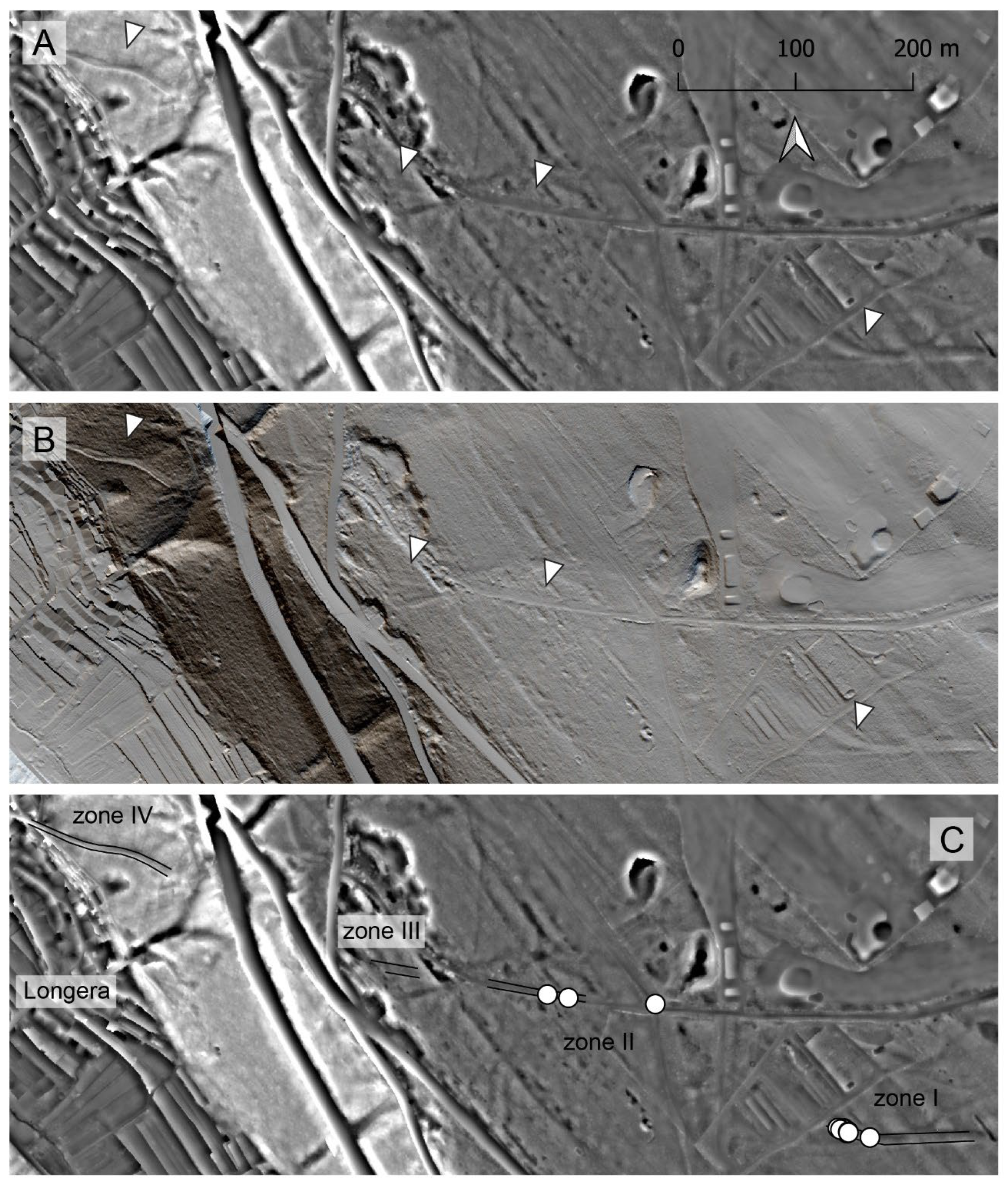
3. Results
The elaboration of ALS DTMs made it possible to identify several kilometers of road network, in many cases detectable as large road tracks lower than the surrounding topographic surface and produced by the prolonged passage of carriages. In some areas several sub-parallel tracks, covering tens of meters, are preserved, suggesting they shifted over time (
Figure 2e). The existence of such large belts crossed by multiple road tracks in the Karst was already recognized along the road west of the Grociana piccola hill, more precisely, immediately west of the Foiba di Basovizza ([
9], supplementary Figure S10).
The evidence collected confirm the strategic importance of the crossroad just north of Grociana piccola hill. Based on the new data, the road identified north of the Roman camps continued almost straight westward and descended towards Trieste at the current village of Longera (
Figure 2g and
Figure 3; hereinafter conventionally labelled as road 1 or
Tergeste–Grociana piccola). Still immediately north of Grociana piccola, the road that led from
Tarsatica to
Aquileia continued north-west (
Figure 2a–f and
Figure 3; hereinafter conventionally labelled as road 2 or
Aquileia–
Tarsatica). Finally, another route to present-day central Slovenia via the Razdrto pass (the ancient
Ocra) branched from
Aquileia–Tarsatica in the same area (
Figure 2h and
Figure 3; hereinafter conventionally labelled as road 3 or Grociana piccola–
Emona). Very close to the Grociana piccola crossroad a big rural structure was already identified by Bernardini et al. [
9].
Two other large structures, probable Roman rural buildings, have been identified in the central-western part of the investigated area (
Figure 2i–l). Interestingly enough, both are surrounded by the remains of a boundary wall which probably delimited the pertinent lands. As described below, the north-eastern side of these walls fits perfectly within one of the centuriation axes of the Trieste area ([
9], Supplementary Figure S15; [
41]).
On the ground, all these features correspond to topographic anomalies such as bumps or ridges covered by grassland and modern land division walls.
The attribution of the road tracks to the Roman period is confirmed by the numerous
caliga hobnails, collected especially in the A, B and G sectors of
Figure 2, stratigraphic evidence, numismatic finds and by the discovery of remains possibly attributable to a graveyard not far from the
Aquileia–Tarsatica road section (
Figure 3). The
caliga hobnails published here for the first time are added to those collected in the last years [
9] in the investigated area for a total of almost 400 artefacts.
The identified features are presented in detail in the next paragraphs together with the associated archaeological artefacts.
3.1. Aquileia–Tarsatica
Most of the identified road segments belonging to this route correspond to sectors A–F represented in
Figure 2 and are illustrated in the following figures.
Immediately north-east of Grociana piccola and a little further north of road 1, a concentration of dozens of
caliga hobnails had been identified in an area used as a parking lot [
9]. Their presence is due to the fact that the continuation of road 2 in the direction of
Aquileia should be placed right here. This is demonstrated by the new road sections identified in area A (
Figure 4). Along one of them, some
caliga hobnails without any signs have been found (
Figure 5, nn. 1–3), confirming the Roman attribution of the route.
After an interruption of just over a kilometer, due to the presence of the village of Basovizza, which erased the traces of the road (
Figure 2 and
Figure 3), its remains have been identified in sector B of
Figure 2. Here several subparallel tracks, covering an area about 30 m large, are visible (
Figure 6). As most of the features presented in the paper, they are covered by modern land divisions and associated with Roman artefacts. More in detail, three hobnails, two of them of type A and one belonging to type E, have been discovered (
Figure 5, nn. 4–6). Additionally, a small iron socketed artefact was found (
Figure 5, n. 7).
Between sector A and B, just west of the center of Basovizza (
Figure 3) and very close to the road 2 path, a Bronze As of Tiberius, minted in Rome between 22 AD and 30 AD (
RIC I
2, [
42], p. 99, n. 81; classification by B. Callegher of Trieste University), was found at the beginning of last century by a local inhabitant (
Figure 1,
Figure 3 and
Figure 7).
Another coin, a Bronze As of Gaius/Caligula, minted in Rome between 37 AD and 41 AD (
RIC I
2, [
42], p. 112, n. 58), was found along the same road, just north-east of Grociana piccola ([
42], 103).
Continuing west from area B, the remains of the road are again recognizable to the west of the Italian Synchrotron Facility (area C), built exactly above the road. Road sections with slightly different orientations have also been recognized in this area, but the presence of vegetation cover prevented the finding of Roman hobnails and other artefacts (
Figure 8). However, in the space between area B and area C and very close to the road (black star in
Figure 3), a fragment of a bronze brooch similar to the type Almgren 69 ([
43], p. 126, n. 292) and a few pottery fragments were found together. They could be part of a burial datable to the second half of the first century AD based on comparisons with similar brooches (see references in [
43]).
After area C, the traces of the road continue in the same direction for about 1 km (area D;
Figure 9) and then turn north (area E;
Figure 10), maintaining more or less the same elevation above sea level, until the road skirts the internal base of the Karst coastal ridge continuing in the direction of Prosecco (
Figure 1). In this area, the coastal chain of the Karst and the offshoots of the more internal elevations delimit a narrow corridor, about 1 km wide, where searches focused on, allowing me to identify a stretch of the road route (Area F;
Figure 11). Interestingly enough, even today the modern road network is concentrated within this band.
In area E, a
caliga hobnail of type A has been found along the road (
Figure 5, n. 10).
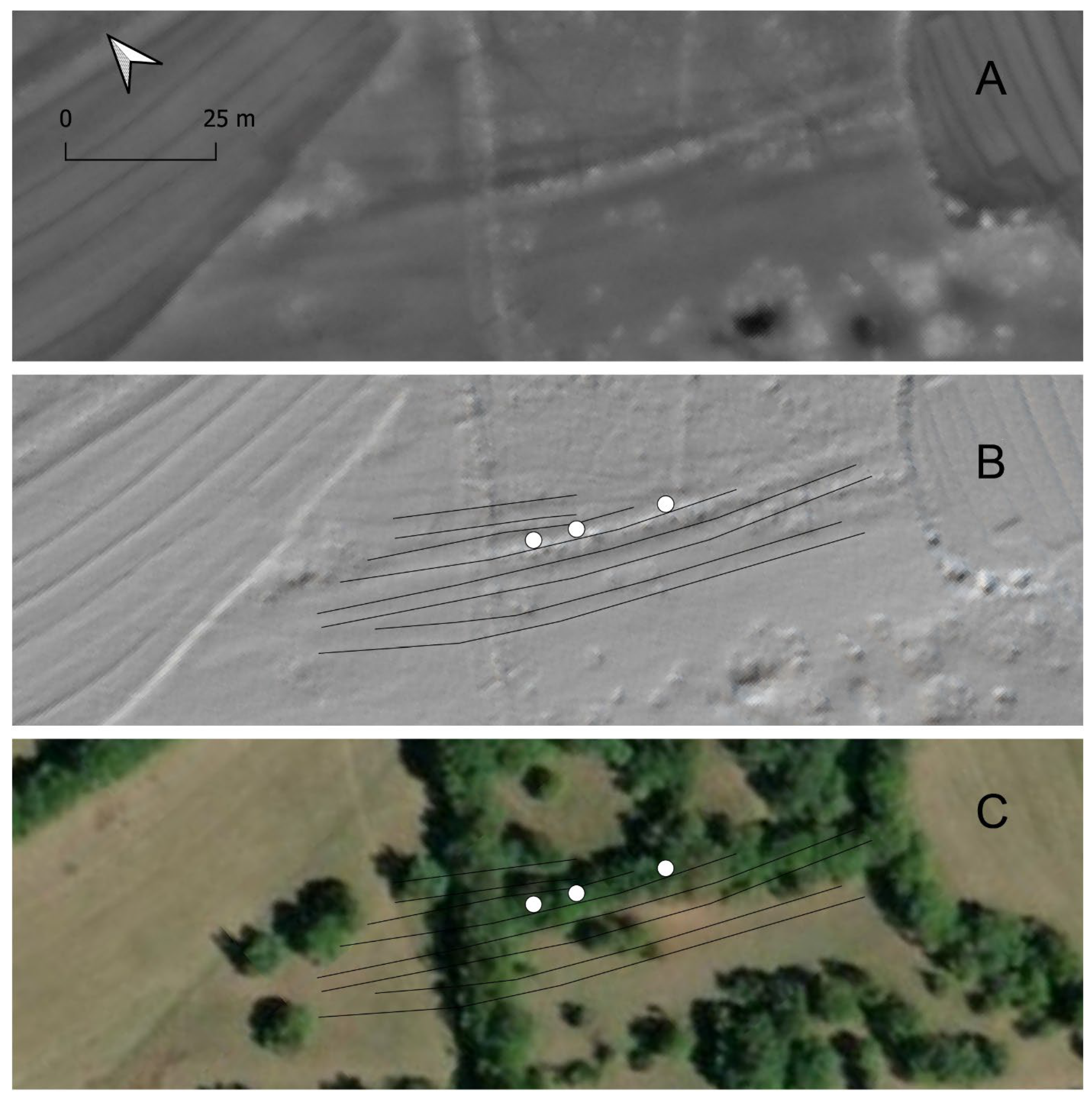
3.2. Tergeste-Grociana Piccola
Almost 3 km of this route, starting from Grociana Piccola and heading west towards Trieste, were identified and mapped by Bernardini et al. [
9], but the data available at the time did not allow them to establish where the road descended from the Karst plateau to reach Trieste (
Figure 2). The ALS data have highlighted in the wood a stretch of the ancient route about 10 m wide (area G,
Figure 12C, zone I), associated with a very large number of
caliga hobnails (
Figure 13, 1–3, 5–6, 9–15). The latter include types A, C and D, indicating that the route was certainly in use at least from the 1st century BC. The direction of this road segment points towards the village of Longera, where the collected data indicate that the road probably left the Karst plateau following an almost straight path (
Figure 2 and
Figure 12).
A little further west of zone I, described above, the layout of the road probably coincides with a short stretch of path in use in later historical times (zone II of
Figure 12C), as apparently demonstrated by some hobnails of type A and D (
Figure 13, nn. 4, 7–8), and descended rather steeply following a track partially cut into the bedrock (zones III and IV of
Figure 12C) to reach the area of nowadays Longera, thus abandoning the Karst plateau.
3.3. Grociana Piccola-Emona
The presence of a route that left the
Aquileia–
Tarsatica road to the north of Grociana piccola was already suggested by Bernardini et al. [
9] on the basis of the dozens of
caliga hobnails found in the area. Since then, other hobnails have been found, and some possible road tracks covered by land divisions, documented in the 19th century land register, have been identified (area H,
Figure 14).
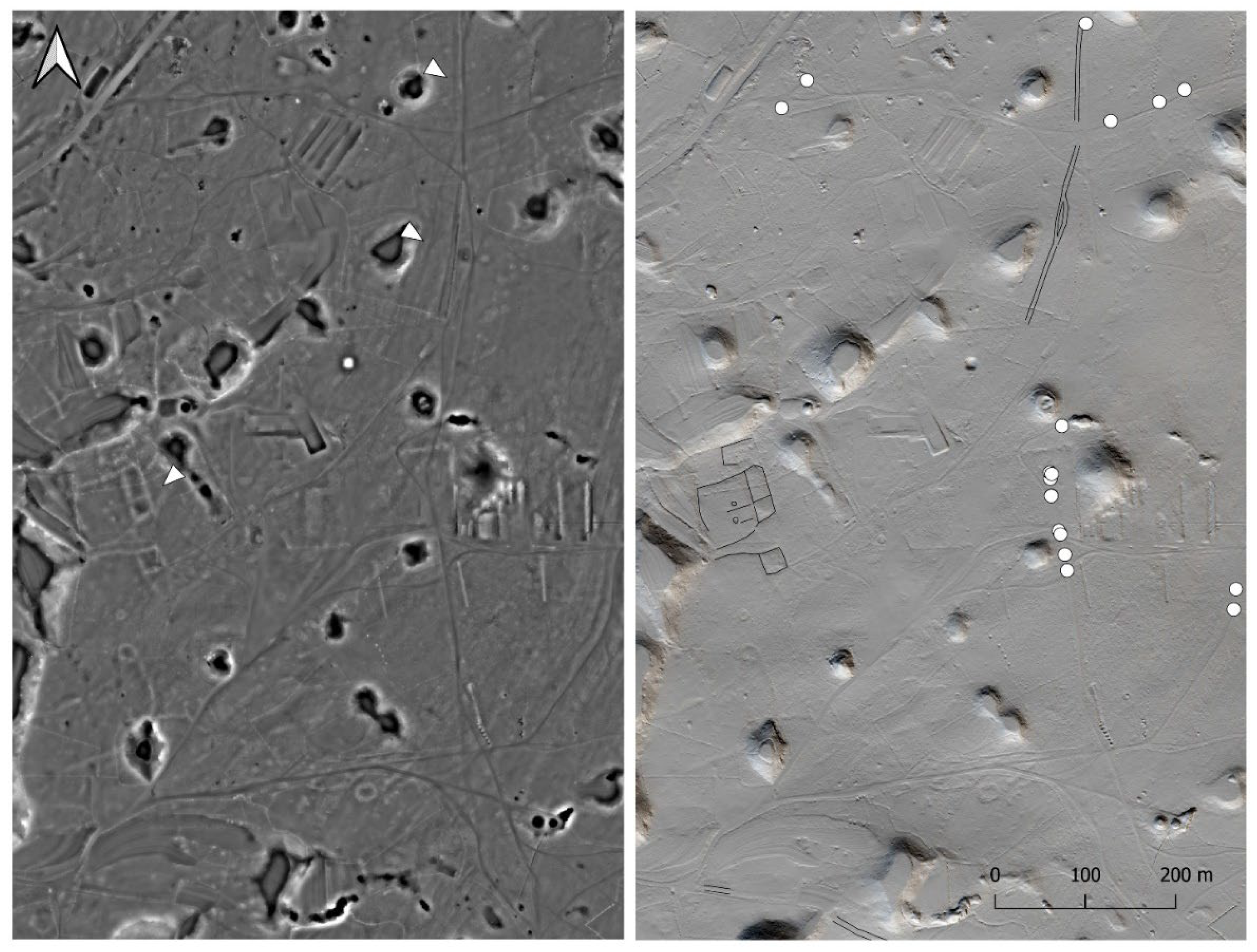
3.4. Rural Buildings
Three rural buildings have been identified in areas H, I and L of
Figure 2.
A large complex (about 1 ha), already identified by Bernardini et al. [
9] and attributed to the Roman period, is located just north of the Grociana piccola crossroad in area H, and more precisely about 350 m from the
Aquileia–Tarsatica road and 300 m from the Grociana piccola–
Emona road (
Figure 2,
Figure 3,
Figure 14 and
Figure 15). In the north-eastern part, it shows a rectangular building of about 20 × 60 m containing at least one transversal wall and overlooking a probable courtyard of about 50 × 50 m. A similarly oriented building (i.e., about 75 degrees east of north) of about 20 × 20 m lies approximately 30 m south of the rectangular construction.
The other two rural buildings are surrounded by a wall which probably delimited the land belonging to them (
Figure 16,
Figure 17,
Figure 18 and
Figure 19). The wall is not present on the south-western side where the natural slope made it unnecessary, while, on the opposite side, it fits perfectly within one of the axes of the Karst centuriation, perhaps the
decumanus maximus (
Figure 17; [
41]), oriented about 42 degrees east of north. The extension of this centurial axis north-west roughly coincides, indeed, with the stretch of the
Aquileia–Tarsatica road between Prosecco and Aurisina (
Figure 1B). The term centuriation refers to the method with which the Romans divided public land into
centuriae, regular square plots measuring about 710 m per side (20 × 20
actus), in order to be able to assign it to new colonies. This land division system was based on a grid consisting of
limites, comprising perpendicular roads called
decumani and
cardines. The main roads were called
decumanus maximus and
cardo maximus [
41].
Both buildings, located about 300 m south-west of the
Aquileia–Tarsatica road, are covered by modern land divisions and show approximately the same centuriation orientation, but the one within area I (
Figure 16,
Figure 17 and
Figure 18) is larger than the one in area L (
Figure 19 and
Figure 20) (90 × 18 m vs. 43 × 20 m respectively).
Finally, some orthogonal features have been identified in area M, but they can be only hypothetically attributed to ancient times in the absence of stratigraphic relations with modern structures and archaeological materials (
Figure 21).
4. Conclusions
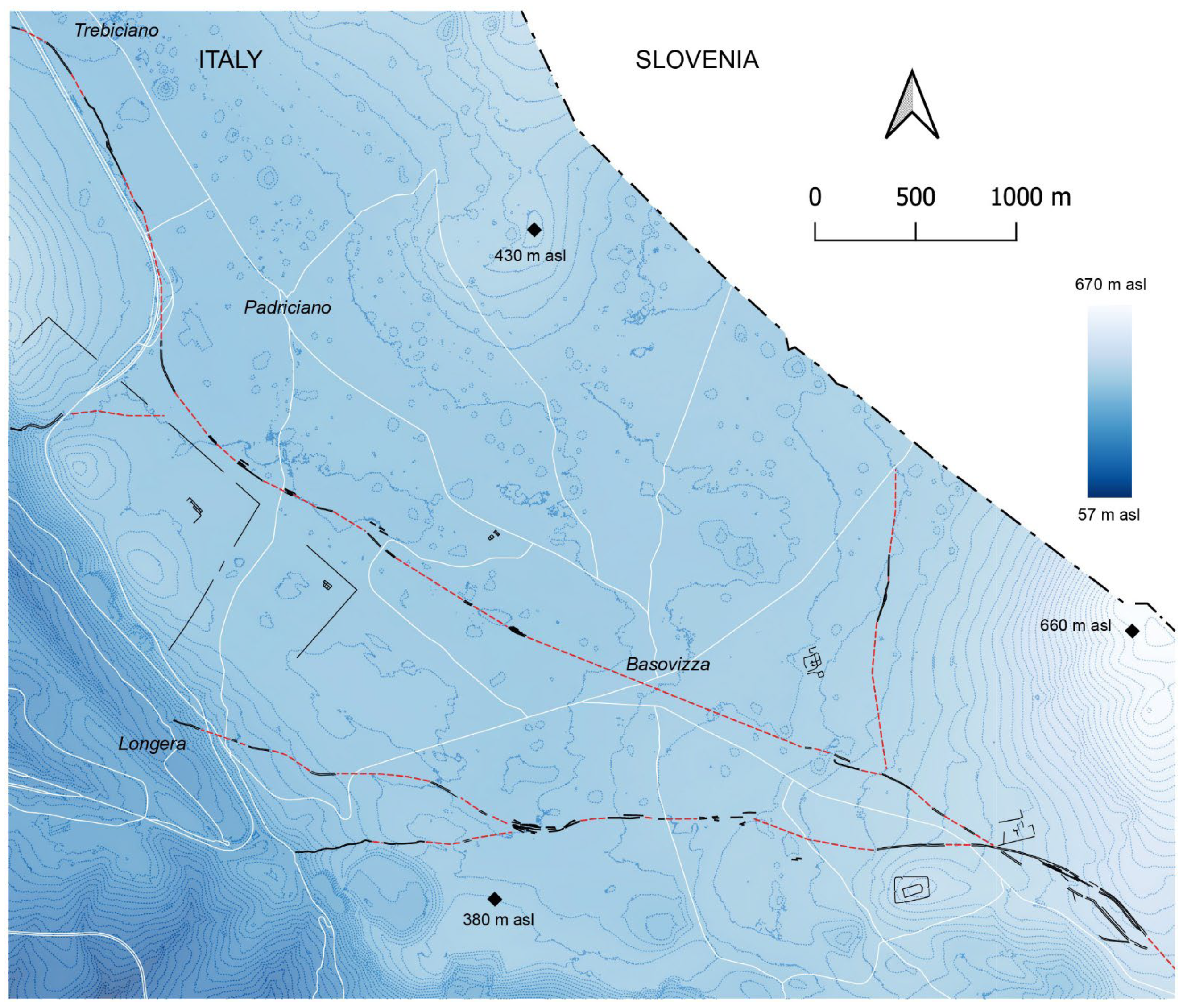
The study of high-resolution ALS terrain models, associated with field surveys, the geomorphological and stratigraphic study of superimposed landforms and the collection of archaeological artefacts, has made it possible to rediscover the lost Roman landscape in the investigated area with an unprecedented level of detail: over 10 km of road routes, some large rural buildings next to them, sometimes enclosed within land divisions perfectly aligned with the centurial grid of the Karst.
The southern part of the Trieste Karst was crossed by a series of important road axes which met a little further north of the Roman camps of Grociana piccola. Here passed the road that led from
Aquileia to
Tarsatica, from which the paths leading north, towards
Emona, and west, towards
Tergeste, separated (
Figure 22 and
Figure 23). The camps of Grociana piccola were in fact built in a strategic spot, from which the main communication routes could be controlled. The origin of the important road junction can, indeed, already be dated to the late Republican era, as demonstrated by the Alesia type D hobnails found along the
Aquileia–
Tarsatica road, but also along the other routes.
Based on the data collected, the main route that led to Tergeste, after having abandoned the Aquileia–Tarsatica road, passing a few tens of meters north of Grociana piccola, continued westward in an almost straight direction to descend towards Tergeste at the current village of Longera.
On the contrary, the origin and chronology of the road layout that reached the Karst plateau at the Monte Spaccato pass (
Figure 22 and
Figure 23) is not clear. Although its attribution to the Roman period dates back to the end of the 17th century ([
20,
21] and references in there), unfortunately there is no direct evidence to date its construction with greater precision. The archaeological surveys did not allow for the collection of Roman hobnails, but this could depend on the strong washout that characterizes its steep route, nor did the study of the terrain models reveal any ancient road route at its outlet on the Karst plateau. Any traces may have been cancelled by the earthworks carried out for the construction of the modern road network.
However, another aspect to take into consideration is that such a route probably had to cross, at least in some periods, the space delimited by the wall which surrounded the rural building in area I. This boundary wall shows three interruptions along the north-eastern side, of which the westernmost and easternmost are certainly modern, while the central one could be ancient, but the wall could have alternatively disappeared due to historical and modern agricultural practices. However, in correspondence with this last passage, one would expect to recognize ancient road traces associated with abundant caliga hobnails, while none have been discovered.
The three large rural buildings identified are within easy reach of one or more road routes. The structures in areas I and L of
Figure 2 are located about 300 m south of the
Aquileia–Tarsatica road, while the structure in area H of
Figure 2 is located about 500 m from the Grociana piccola crossroad and is bordered to the east by Grociana piccola–
Emona road and to the south by
Aquileia–Tarsatica one. Therefore, all the structures are adjacent to the
Aquileia–Tarsatica road, which proceeded straight from Sistiana and followed for a long stretch one of the main axes of the centuriation along the inner edge of the Karst ridge (
Figure 1B). After reaching Prosecco, where the road to
Tergeste branched off, the
Aquileia–Tarsatica road continued south-east to reach the investigated area (
Figure 1B,
Figure 2,
Figure 22 and
Figure 23).
As mentioned in the archaeological introduction, along this route the itinerarium Antonini places a road station, Avesica, 12 Roman miles from the one at the Timavo springs, corresponding to about 18 km. The same itinerary places Tergeste along the way to Istria at the same distance, which, however, is about 25 km away. Interestingly enough, the studied area is located approximately at the same distance that separates Tergeste from the Fons Timavi.
It should also be noted that the ongoing study of the ALS DTMs of the area between Prosecco and Basovizza has not led so far to the identification of any other Roman rural structure of large dimensions similar to those of areas H, I and L. This is significant because the Karst landscape is conservative and relatively well preserved along this route with the exception of the Prosecco village and some other spots. As an example, it is enough to recall how ALS made it possible to clearly identify even temporary structures such as the external military camp of Grociana piccola [
9].
On the basis of these considerations, and discarding the identification of
Avesica with Prosecco on the basis of Bosio’s considerations [
26], it is legitimate to ask whether one of the structures identified near Basovizza could correspond to
Avesica.
According to Bosio’s hypothesis [
26], which the author of this paper shares, since the
itinerarium Antonini places
Tergeste and
Avesica at the same distance from
Fons Timavi (i.e., 12 Roman miles), they cannot be located along the same route. Being located along the way to
Tergeste, Prosecco cannot correspond to
Avesica.
Among the buildings identified in the investigated area, the structure of area H could most likely correspond to Avesica, above all due to its proximity to the strategic road junction which made it possible to reach Aquileia, Tarsatica, Emona and Tergeste.
Although the planimetric characteristics of the road stations (
mansiones) are difficult to distinguish from those of important rural buildings or villas [
44], the presence of large buildings overlooking a large courtyard is compatible with the proposed identification. It goes without saying that this hypothesis will have to be tested through stratigraphic excavations, which are necessary for defining the nature and chronology of archaeological structures.
Whether or not the proposed identification is correct, the collected data show the long-term strategic importance of the Grociana piccola area, from the installation of the camps in the Republican period (between the 1st−2nd centuries BC), probably connected to the first road construction, to the presence of a fundamental crossroad in use for hundreds of years. In the post-Roman period the here described Roman road system was abandoned, but the role of important road junction played by this territory was preserved, with the formation and repositioning of a new crossroad about 1 km westward by the town of Basovizza (
Figure 23).


