the Creative Commons Attribution 4.0 License.
the Creative Commons Attribution 4.0 License.
 | 16 Sep 2021
Last Interglacial sea-level proxies in the western Mediterranean
Matteo Vacchi
Alessandro Fontana
Alessio Rovere
We describe a database of Last Interglacial (Marine Isotopic Stage 5) sea-level proxies for the western Mediterranean region. The database was compiled reviewing the information reported in 199 published studies and contains 396 sea-level data points (sea-level index points and marine- or terrestrial-limiting points) and 401 associated dated samples. The database follows the standardized WALIS template and is available as Cerrone et al. (2021b, https://doi.org/10.5281/zenodo.5341661).
- Article
(67535 KB) - Full-text XML
-
Supplement
(570 KB) - BibTeX
- EndNote


In this paper, we describe the Last Interglacial (here broadly defined as Marine Isotope Stage, MIS, 5) sea-level database for the western Mediterranean, which was compiled from data and metadata contained in published scientific papers reporting geological evidence and dated samples related to Quaternary sea-level changes in the region. Information on sea-level proxies and dated samples was standardized using the WALIS interface, which is accessible (upon registration) at this link: https://warmcoasts.eu/world-atlas (last access: 30 July 2021). From the interface, the database was exported in spreadsheet format and made available as a multi-sheet Excel file in Zenodo under a CC-BY license (Cerrone et al., 2021b, https://doi.org/10.5281/zenodo.5341661). Database field descriptions are also available in Zenodo https://doi.org/10.5281/zenodo.3961544 (Rovere et al., 2020) and are synchronized with a read-the-docs website here: https://walis-help.readthedocs.io/en/latest/ (last access: 30 July 2021). In the Supplement of this paper, we report a table summarizing elevation, age, reference(s), and quality scores for each relative sea-level (RSL) data point in the western Mediterranean database.
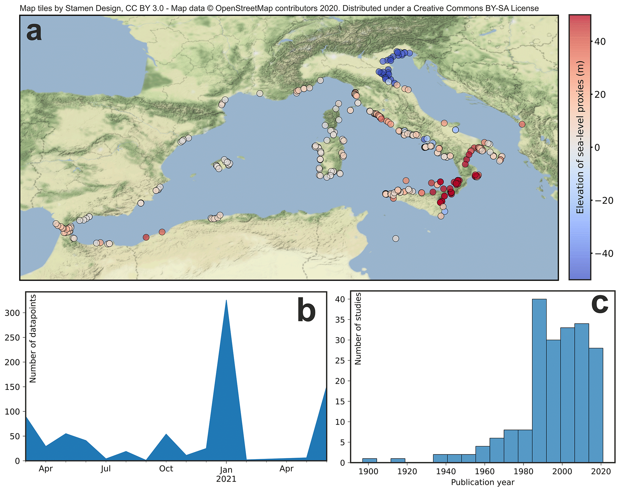
Figure 1Overview of the western Mediterranean database. © OpenStreetMap contributors 2020. Distributed under the Open Data Commons Open Database License (ODbL) v1.0. (a) Elevation of sites within the reviewed geographic area. (b) Data ranges of database creation. (c) Year of publication of reviewed studies.
The data and metadata compiled in this paper were extracted from 199 studies (Fig. 1a) mostly published in the last 40 years (Fig. 1c). The data compilation was done between March 2020 and June 2021 (Fig. 1b). Therefore, data contained in papers published during this time frame may not be included in our database. The database includes data from the Mediterranean coasts of Spain, France, Italy, Albania, Algeria, and Morocco. The coasts of Tunisia and Libya, which lie at the transition between the western and eastern Mediterranean basins, are the subject of another compilation (Mauz, 2020). On the eastern Mediterranean side, compilations are available for Israel (Sivan and Galili, 2020) and Cyprus (Zomeni, 2021). We did not include in the database cave deposits previously used as sea-level indicators in Mallorca (Spain) and Croatia in order to avoid duplication of data within WALIS, as these deposits are part of another compilation (Dumitru et al., 2021b). Overall, the western Mediterranean database contains 328 sea-level index points (for which paleo relative sea level can be calculated), 43 marine-limiting points (indicating that sea level at the time of formation was above the reported facies), and 25 terrestrial-limiting points (indicating that sea level at the time of formation was below the reported facies). Each data point was associated with one or more dated samples or linked to a chronostratigraphic attribution.
In the following sections, we first give an overview of the classic literature describing the Last Interglacial sites in the western Mediterranean. Many of the older studies mentioned in this section do not contain all the metadata necessary to meet the WALIS standards (i.e., they are missing key information on location, elevation, or age); they represent the foundations upon which studies inserted into our database were developed. Next, we give a brief description of the types of sea-level indicators, elevation measurement techniques, sea-level datums, and dating (or age attribution) techniques contained in the database. We then turn to the description of the data points divided by national/regional/provincial boundaries. This part of the paper serves as a supplement to the data, where we provide additional descriptions and/or information on choices made during the compilation.
In the western Mediterranean, the investigation of Quaternary marine and coastal deposits dates back more than 1 century. At the beginning of the 20th century, several physical geographers and geologists worked on both sides of the basin, describing outcrops correlated with the then-called “Tyrrhenian” sea-level highstand (Issel, 1908; de Lamothe, 1911; Gignoux, 1913; Blanc, 1936), later identified with MIS 5. This “first wave” of authors was followed by a series of geoscientists who detailed the first stratigraphic descriptions and explored new sites (e.g., Butzer and Cuerda, 1962; Ottmann, 1954; Bonifay and Mars, 1959). This “second wave” was supported by the development of dating techniques such as U series (Stearns and Thurber, 1965), which helped to strengthen previous chronological correlations that were heretofore based almost uniquely on (bio)stratigraphic correlations.
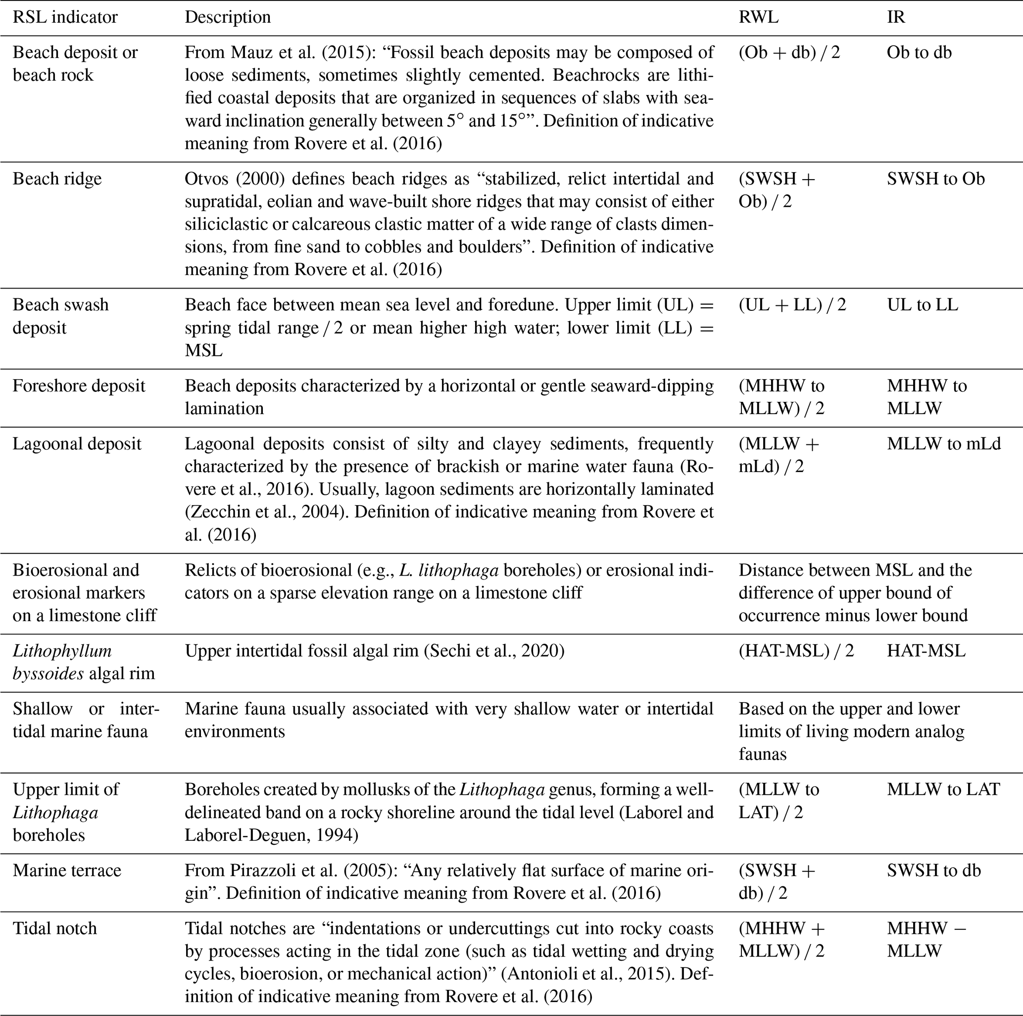
Table 1Sea-level proxies used in the western Mediterranean database. Abbreviations as follows. RWL: reference water level; IR: indicative range; Ob: ordinary berm; db: breaking depth; SWSH: storm wave swash height; MHHW: mean higher high water; MLLW: mean lower low water; mLd: modern lagoon depth; HAT: highest astronomical tide; LAT: lowest astronomical tide; MSL: mean sea level.
These studies laid the foundation upon which, in the 1980s and 1990s, works on western Mediterranean Last Interglacial outcrops flourished. Among the many works done in these 2 decades, it is worth mentioning the work of Hearty (1986), who applied amino acid racemization to a vast number of Mediterranean sites. This work appeared in a special issue of the journal Dating Mediterranean Shorelines, edited by Ozer and Vita-Finzi (1986). This volume also contains the first (to our knowledge) Mediterranean-wide synthesis of Last Interglacial data (Flemming and Webb, 1986) and collects the results of the first applications of electron spin resonance (ESR) dating on western Mediterranean outcrops, which was pioneered by Radtke et al. (1981), Radtke (1983), Brückner (1986), and Brückner and Radtke (1986).
The renewed interest stirred by the Dating Mediterranean Shorelines volume is reflected in a large number of studies that appeared in the scientific literature during the late 1990s and 2000s. Our western Mediterranean database is largely based on these works (see the detailed regional descriptions below) and on the regional/national data syntheses that were carried out by several authors in the last 20 years (Bordoni and Valensise, 1999; Nisi et al., 2003; Zazo et al., 2003; Ferranti et al., 2006) alongside detailed studies providing age and RSL information at sites in the western Mediterranean basin.
Within the western Mediterranean, we identified 11 types of sea-level indicators (Table 1). The most widespread ones are marine terraces, beach deposits (or beach rocks), and tidal notches (Fig. 2). For each location where Last Interglacial shorelines were reported, we derived the upper and lower elevations at which the same landforms/deposits occur along the modern shoreline. For this purpose, we used modern analog data whenever available. However, such data are not often reported; therefore, for the majority of data points we used the IMCalc tool (Lorscheid and Rovere, 2019), which allows extraction of ex situ values for the calculation of the relationship between the dated facies and the contemporary mean sea level (Shennan et al., 2015). Such a relationship is commonly defined as the indicative meaning and is quantified via the indicative range and the reference water level, which are defined as, respectively, the range occupied by a sea-level index point and its midpoint (Shennan et al., 2015).
The most represented type of sea-level indicators in our compilation are marine terraces. Despite having a broad indicative range, marine terraces have been widely used to assess late Quaternary vertical land movements, starting from an assumption about the “eustatic” sea level at elevations included between 3 and 9 m above present (Ferranti et al., 2006, and references therein). However, recent work (Stocchi et al., 2018) showed that this approach should be used with caution due to the intrinsic uncertainties related to glacial and hydro-isostatic adjustment and eustatic sea level.
The other two widespread sea-level proxies are fossil beach deposits and tidal notches. For tidal notches, we only considered those forming on vertical cliffs at or close to the tidal level. We expressly excluded from our compilation abrasion notches, i.e., indentations on the cliff face caused solely by mechanical erosion exerted by waves mobilizing sediments (sand or pebbles), abrading against the rock. These can occur within a large elevational range, from above the storm berm to well below sea level, and are generally considered poor sea-level indicators (Rovere et al., 2016).
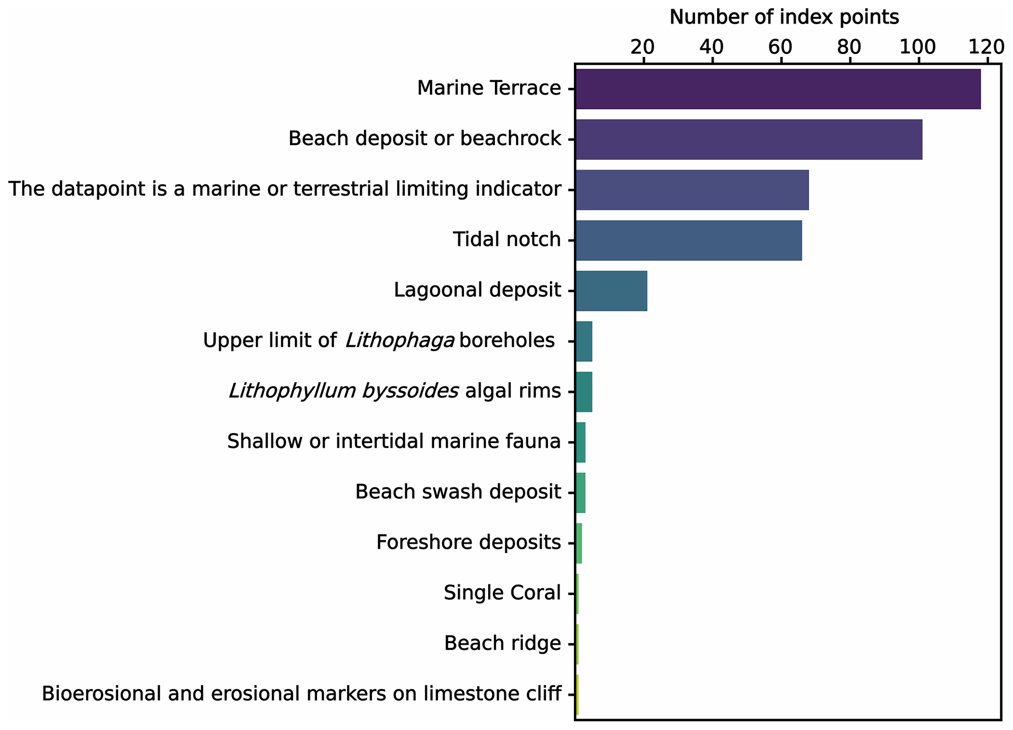
Figure 2Types of sea-level indicators and number of sites where they are present within the western Mediterranean database.
The elevation of the large majority of sea-level index points reported in the database was measured with metered tapes or rods and is referred to as a general “mean sea level”, with no additional information provided (Fig. 3a, b). Whenever the elevation measurement technique and datum were not reported in the original study, we set the elevation error to 20 % of the elevation value. If only the sea-level datum was not reported, we set it to 5 %. We note that the majority of studies do not report precise coordinates for the sites investigated. Therefore, at many sites, we derived geographic coordinates with the aid of location names identified in geolocation services (e.g., Google Maps) or georeferencing maps from original publications in QGIS. This means that the location reported in the database is, for many sites, only indicative and may be off even by hundreds of meters or a few kilometers (Fig. 3c).

Figure 3Elevation measurement (a), sea-level datums (b), and horizontal positioning (c) associated with sea-level indicators in the western Mediterranean database.
In the western Mediterranean, Last Interglacial sea-level indicators have been assigned an age through a large array of techniques (Fig. 5). U-series dating was used to date corals preserved at several locations (Fig. 5a). The vast majority of dated corals are specimens or fragments of Cladocora caespitosa (Linnaeus, 1767). Nearly two-thirds of the corals were dated with mass spectrometry, while one-third was dated via the older alpha-counting technique. We also included in the database 52 U-series ages on mollusks or corallinaceous algae (Fig. 5b). Due to issues with the open-system behavior of these fossils, WALIS only allows the attribution of a general marine isotopic stage to mollusks and corallinaceous algae. This was based on the reported ages and, if present, correlated discussions in the original paper. While we did not include in our compilations the cave deposits from Mallorca and Croatia (that were, as noted in the introduction, already compiled in WALIS by Dumitru et al., 2021b), we inserted several speleothems that were dated in southern Italy and Morocco to support the chronological attribution of sea-level indicators in these areas (Fig. 5c).
Optically stimulated luminescence (OSL), thermoluminescence (TL), infrared-stimulated luminescence (IRSL), and ESR techniques were used to date coastal deposits at several locations, mostly in Italy (Fig. 5d, f). Much more widespread is the use of amino acid racemization (AAR) on mollusks (Fig. 5e). This technique was used to strengthen biostratigraphic correlations among sites. In general, mollusks falling into “Aminozone E” were correlated with MIS 5e thanks to Cladocora corals dated with U series at sites where mollusks and corals were found within the same deposit (Hearty et al., 1986a).
In general, only samples dated with U series (corals or speleothems), luminescence, and ESR have been assigned radiometric ages and associated 2σ uncertainties. Overall, the ages in the database cover most of MIS 5 (Fig. 4a, b), but MIS 5a, MIS 5c, and MIS 5e peaks cannot be easily distinguished (Fig. 4a). This indicates that most radiometric ages in the western Mediterranean have large error bars, making it challenging to distinguish between MIS 5 peaks only based on dating.
Chronostratigraphic and bio-stratigraphic correlations among sites are very common throughout the western Mediterranean (Fig. 5g). Among these, one of the most widespread is related to the presence, embedded within Pleistocene deposits, of “Senegalese fauna” (Benjamin et al., 2017). The “Senegalese fauna” term is used to identify an assemblage composed of the following species: Persistrombus latus (Gmelin, 1791), Conus testudinarius, Cantharus viverrata, Tritonium ficoides, Natica lactea, N. turtoni, Mytilus senegalensis, Arca geissei, Cardita senegalensis, and some other species present in minor percentages (Gignoux, 1913). The name “Senegalese fauna” derives from the fact that its most representative species, P. latus (Fig. 6), currently lives along the Atlantic coasts of western Africa at warm low latitudes from Angola to Senegal. Deposits with Senegalese fauna are encountered throughout the western Mediterranean, excluding the coasts of the northern part of the Adriatic Sea.
The presence, within a western Mediterranean Pleistocene deposit, of Senegalese fauna or P. latus is often used to denote an MIS 5e age of the deposit itself. However, this chronological attribution has been challenged, at least for the Mediterranean coasts of Spain, by the fact that P. latus was found on marine terraces dated to MIS 5, MIS 7, and MIS 9 (Zazo et al., 2003). Details on the arguments for and against the attribution of P. latus-bearing deposits to MIS 5e are summarized in a series of comments and replies to Bardají et al. (2009a) by Mauz and Antonioli (2009) and Bardají et al. (2009b). In our compilation, we assigned deposits bearing Senegalese fauna a general MIS 5 age, meaning that we deem it possible that this faunal assemblage was present in the western Mediterranean at least throughout the different warm peaks of this marine isotopic stage (namely, MIS 5a and MIS 5c). We also note that, at many sites where Senegalese fauna was described, independent datings (e.g., AAR, luminescence, U series) confirmed the MIS 5 age of the deposit. Moreover, we highlight that, in western Mediterranean Pleistocene sea-level studies, the species name Strombus bubonius (Lamarck, 1822) is widely used to indicate the gastropods of the Strombidae family instead of the more appropriate Persistrombus latus (Gmelin, 1791), as recently established by Kronenberg and Lee (2006) and Harzhauser and Kronenberg (2008). Throughout our database, we, therefore, used P. latus even when the original authors used the now obsolete designation Strombus bubonius. We note that the living depth range of “Senegalese fauna” is rather wide. Added to the fact that, in western Mediterranean deposits, the faunal remains are often found not in situ and are fragmented (i.e., they have been likely transported in the littoral zone), the best practice is to identify the association with paleo RSL through the characteristics of the deposit (i.e., cross-bedding, grain size) rather than through the paleo living range of these faunal remains. This is the approach we followed in our review.
A second particular type of chronostratigraphic attribution is the one related to tidal notches (Antonioli et al., 2018). Tidal notches (Fig. 7) are sea-level indicators that have a very narrow indicative range but that cannot be dated directly due to their erosive nature. In general, tidal notches have been dated indirectly by association with nearby deposits of known age. In our compilation, we, therefore, assigned to each tidal notch an age corresponding to the nearest deposit for which chronological constraints are available, similarly to the approach followed by Antonioli et al. (2018).
In the database, we also inserted a small number of “Other” age constraints (Fig. 5h), e.g., limiting radiocarbon dates or argon / argon ages for which there is no standard template within WALIS.
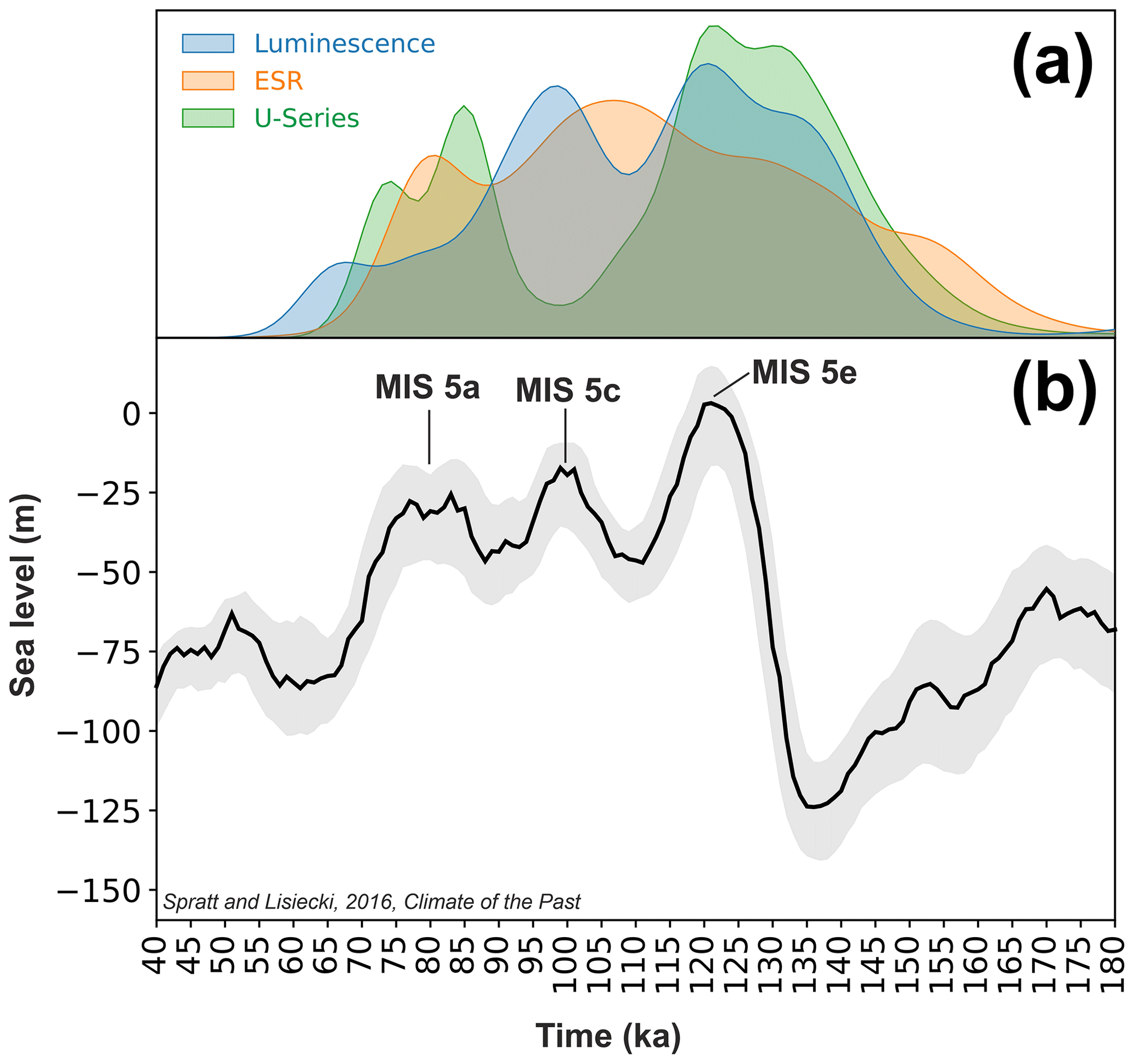
Figure 4(a) Kernel density estimate plots for luminescence, ESR and U-series samples for which a radiometric age is available in the western Mediterranean database. This plot has been obtained by Monte Carlo sampling (n= 100 000) the normal distribution of each dated sample in the western Mediterranean database and plotting the resulting age distributions. (b) Late Pleistocene sea level from Spratt and Lisiecky (2016).
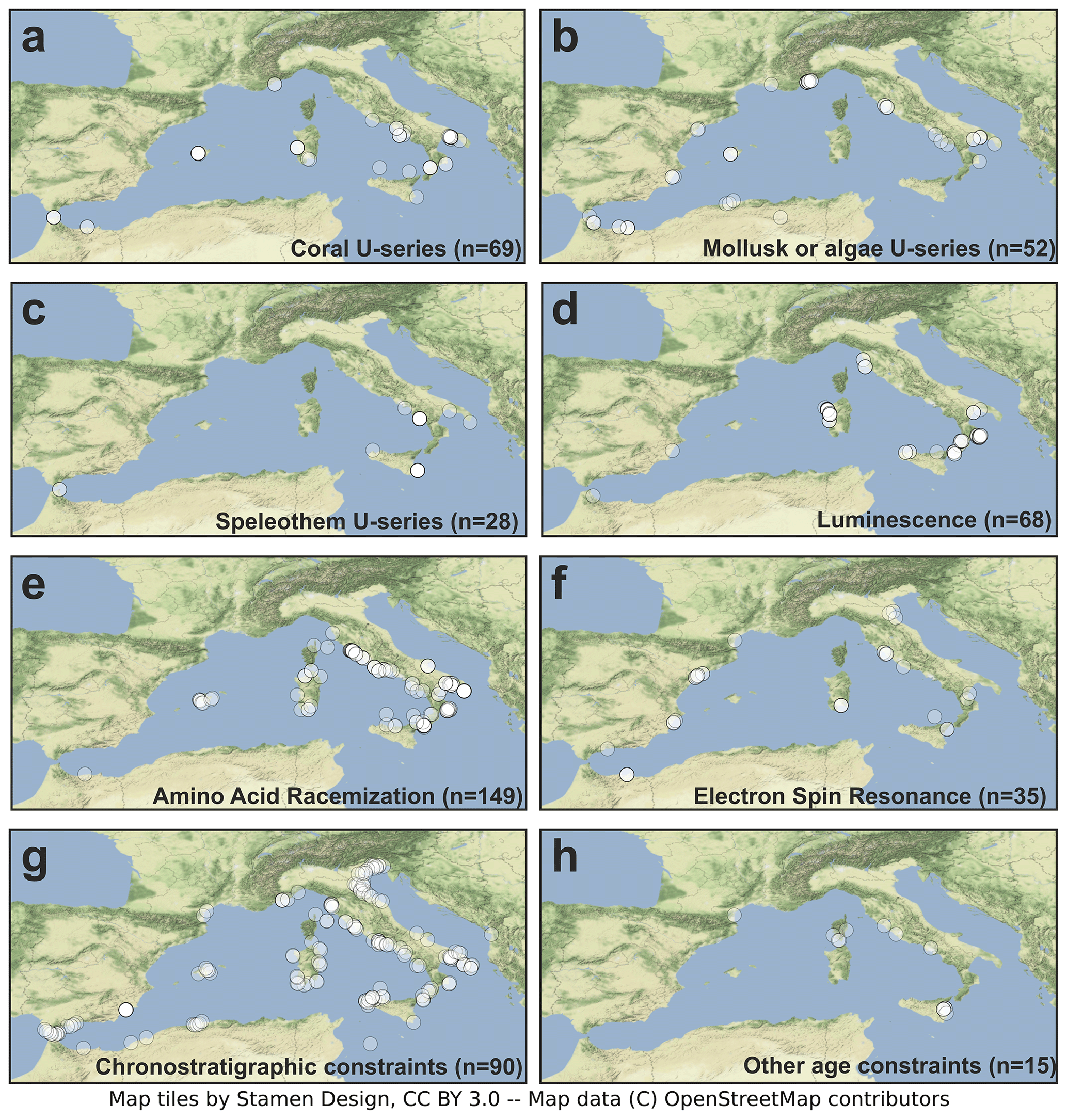
Figure 5Geographic location of dated samples (or chronostratigraphic attributions), divided by type of analysis. © OpenStreetMap contributors 2020. Distributed under the Open Data Commons Open Database License (ODbL) v1.0.
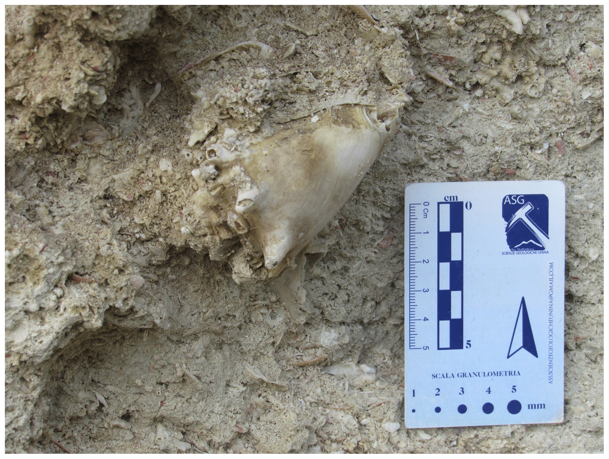
Figure 6Bioclastic calcarenite-bearing Persistrombus latus (reported in many publications with its former name, Strombus bubonius) at Il Fronte site, Taranto, Apulia, Italy. Photo by Ciro Cerrone.
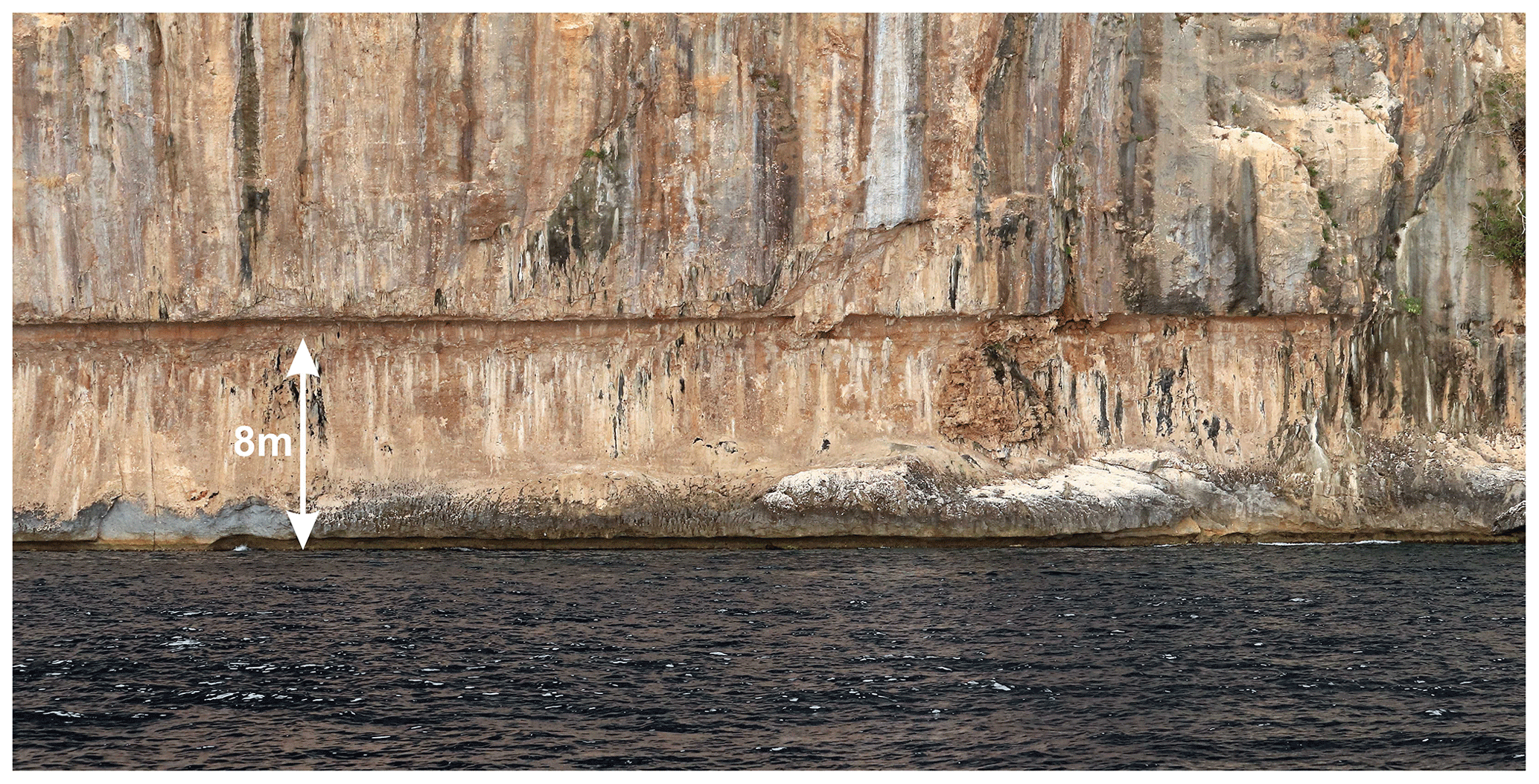
Figure 7Bioerosive tidal notch on the Orosei cliffs, Sardinia, Italy. Note the modern notch carved at the present sea level. Photo by Alessio Rovere.
Table 2Quality ranking as suggested by the WALIS guidelines (verbatim from Rovere et al. (2020), originally published under the CC-BY 2.0 license).
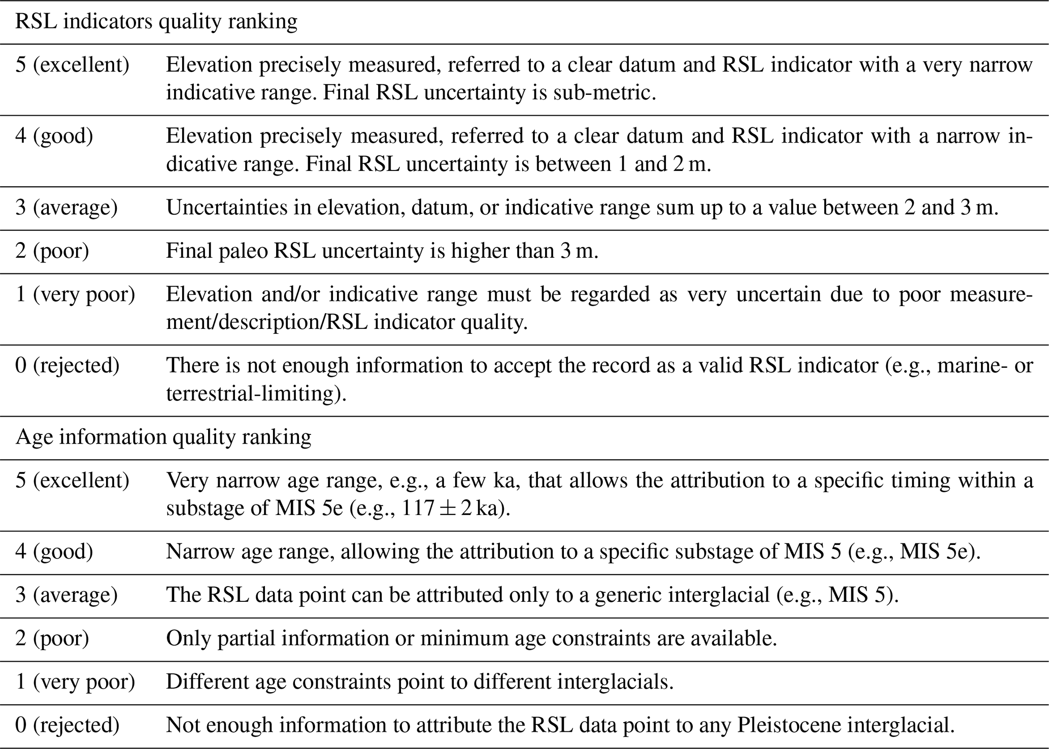
Within the WALIS interface, it is possible to insert a quality score for age and RSL information associated with each sea-level indicator. The ranking follows a simple score (from 0 to 5) that is codified following the general guidelines given in the WALIS documentation (Rovere et al., 2020), which are reported verbatim in Table 2.
In general, if a site was dated only with one among U series on mollusks, AAR, or chronostratigraphic constraints, it was given an “Average” score. Sites where several dating techniques were used concurrently, giving coherent results, received a higher score. In the long stratigraphic cores, the age determination has been ranked to “Average”, while is defined as “Good” when it is based on pollen chronozones and as “Excellent” in the rare cases that ESR dating is also available. Tidal notches are a particular case, as they can only be dated indirectly. For these indicators, the age information quality was systematically set to “Poor”. We note that this is a conservative choice, as the quality of the indirect age attribution for notches might be higher if the dated deposits are close to the notch. In our compilation, we followed whenever possible the WALIS guidelines. In case our quality assessment deviated from the guidelines, the reasons for the scoring choice were detailed in the “Quality notes” field.
Overall, nearly 40 % of points in the database have above-average quality for both age and RSL information, with only three sites reaching an “Excellent” score in both categories (Fig. 8). Among these, two are located in Sardinia and one in Campania (Italy). Sites attaining very high scores are also present in Tuscany (Italy) and the Balearic Islands (Spain). It is worth noting that more than 30 % of the sites in our compilation rank high (good to excellent) for sea-level information but low (average to poor) for age information.
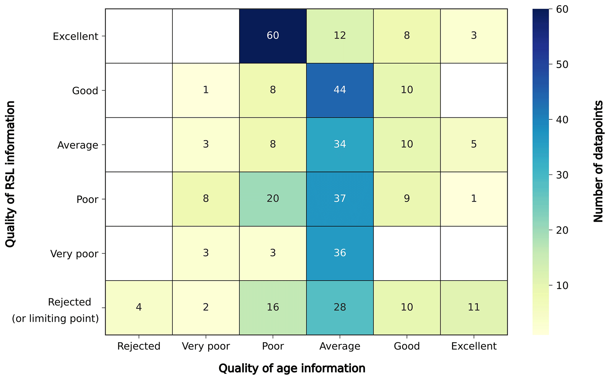
Figure 8Heatmap summarizing the quality of age and RSL information as estimated within the western Mediterranean database. Numbers in each cell detail the number of sites with the corresponding RSL/age quality ranking. The color of each cell represents the number of sites for each category.
In the following sections, we describe the data points inserted into the western Mediterranean database. We start from the coasts of Spain and proceed clockwise across the basin. In the text, we refer to the elevation of sea-level indicators as “a.s.l.” (above present mean sea level) or “b.s.l.” (below present mean sea level). These represent the elevations we derived from the original studies. For regions where sea-level indicators span a significant latitudinal or longitudinal gradient, we present maps and paleo RSL elevation/distance graphs. Site names inserted into WALIS are reported in italics. Wherever possible, we kept location names in the original language or as reported in the reviewed papers. Sites inserted into WALIS are always associated with their corresponding unique RSL ID in parentheses. Whenever mentioned, dated samples are also listed with their unique WALIS ID, e.g., AAR ID, U-series ID.
7.1 Spain (Mediterranean coasts and Gibraltar Strait)
Along the Mediterranean coasts of Spain, Last Interglacial sea-level proxies have been preserved mostly as relic beaches or subtidal deposits containing remnants of Senegalese fauna. While some sites preserved fossil specimens of the coral Cladocora sp., dated to MIS 5e with U series (e.g., Muhs et al., 2015), several other sites rely on chronological constraints given by AAR (e.g., Hearty, 1987), U series on mollusk shells (e.g., Hillaire-Marcel et al., 1996), ESR (e.g., Brückner, 1986) and biostratigraphy (e.g., Bardají et al., 2015). Along the Mediterranean and Strait of Gibraltar coasts of Spain, the Last Interglacial sea-level indicators are concentrated in five regions: Andalusia, Murcia, the Valencian Community (Alicante province), Catalonia, and the Balearic Islands (Mallorca).
7.1.1 Andalusia
The Andalusia region includes sites that are located both in the Mediterranean and on the Atlantic coast, west of the Gibraltar Strait (Fig. 9). Despite this review being focussed on the western Mediterranean, these Atlantic sites are here reported for completeness. In Andalusia, studies on Pleistocene shorelines date back to the late 1980s/1990s (Zazo, 1980; Brückner, 1986; Brückner and Radtke, 1986; Zazo and Goy, 1990). Several sites were reviewed in this area by Zazo et al. (1999) and were inserted into WALIS with RSL IDs from 752 to 765 (nos. 1 to 14 in Fig. 9). Ages were assigned based on chronostratigraphic correlation within sites, some of which were dated using U series on mollusks. In general, MIS 5e deposits in this area are described as “MIS 5e marine remains”. As most of the geological sketches in the original paper show that they are located on a flat surface, we inserted these data points into WALIS as marine terraces, with a broader indicative range than beach deposits. East of Malaga, one site named Cerro Juan (RSL ID 4001, no. 15 in Fig. 9) was described by Brückner and Radtke (1986) and was dated with ESR to MIS 5e (117.3 ka). More towards the east, in the surroundings of the city of Alméria (not shown in Fig. 9), Bruckner (1986) reported several sites that were dated to MIS 5/MIS 5e with ESR and U series on mollusks. The author refers to earlier papers by Goy and Zazo (1982), Baena et al. (1981), and Bernat et al. (1978) for the description and further ages of these sites. As we were not able to retrieve the first two papers and the third one (Bernat et al., 1978) contains only dating metadata, we did not insert any data point for this portion of the Andalusia coast into WALIS.
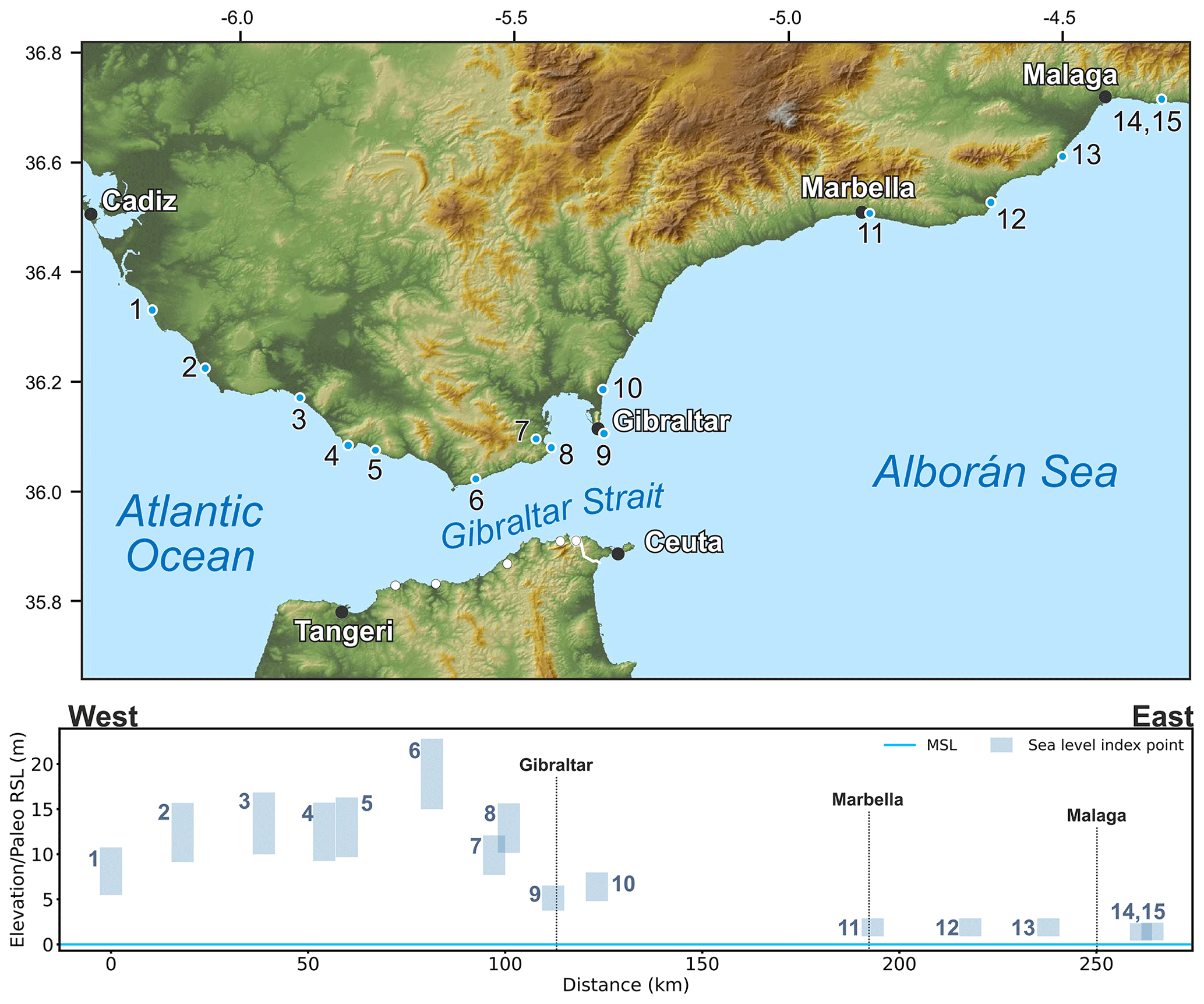
Figure 9MIS 5 sea-level data for Andalusia (Spain). Upper panel: map of sites. Red dots are sites in the region of interest, and white dots are other sites within the western Mediterranean compilation. The topography has been obtained from the Shuttle Radar Topography Mission (SRTM) void-filled digital elevation model (DEM) (Farr et al., 2007, NASA dataset). Lower panel: distance/elevation graph from west (left) to east (right). Sites list: 1: Torre del Puerco (RSL ID 765); 2: Conil-Trafalgar (RSL ID 764); 3: Zahara (RSL ID 763); 4: Cabo Gracia (RSL ID 762); 5: Bolonia – Punta Paloma (RSL ID 761); 6: Tarifa (RSL ID 760); 7: Algeciras 1 (RSL ID 758); 8: Algeciras 2 (RSL ID 759); 9: Gibraltar (RSL ID 757); 10: La Linea (RSL ID 756); 11: Marbella (RSL ID 755); 12: Fuengirola (RSL ID 754); 13: Torremolinos (RSL ID 753); 14: El Candado (RSL ID 752); 15: Cerro Juan (RSL ID 4001).
7.1.2 Murcia
In Murcia, north of Cape Cope, several terraces attributed to different interglacials were reported by studies in the late 1980s/early 1990s (Dabrio et al., 1991; Bardají et al., 1986). The sites were later re-described by Zazo et al. (2003), who clarified that paleomagnetic data and chronostratigraphic correlations with other sites in Almería and Alicante were used to give an age to these deposits. Within the sites in the so-called Cope Basin, the most complete in terms of stratigraphic descriptions and ages was reported from a location called Casa de Renco (RSL ID 750, no. 1 in Fig. 10), where marine conglomerates outcrop up to 5.2 m a.s.l. Bardají et al. (2015) describe the lowermost sedimentological units in 11 outcrops along the Cope Basin (RSL IDs 740–750, nos. 1 to 11 in Fig. 10; see map in the inset). In particular, they assign the shell-rich conglomerate of Unit D to MIS 5e, identifying different sea-level oscillations within it. The authors do not rule out a possible MIS 5a or 5e age for this unit, as its age attribution is based solely on the presence of P. latus and other warm-water faunas. For this reason, in WALIS we reported the 11 sites described by Bardají et al. (2015), where Unit D is reported, and assigned them a general MIS 5 age. It is worth noting that, on a short stretch of coast (2.5 km), the MIS 5 shoreline appears deformed by tectonics, rising from ∼ 2 to ∼ 12 m a.s.l.
7.1.3 Valencian Community (Alicante province) and Catalonia
One of the most studied Last Interglacial outcrops in continental Spain is located in the Valencian Community, within Alicante province, 100 km south of the city of Valencia. Here, studies on the stratigraphy of the La Marina – El Pinet site date back to the 1980s (Bernat et al., 1982; Hearty et al., 1987; Goy and Zazo, 1988; Goy and Zazo, 1989). More recently, Goy et al. (2006) analyzed the stratigraphy of two sections within this site (A and B, RSL IDs, respectively, 751 and 738, nos. 12 and 13 in Fig. 10), where they found evidence of an MIS 7 terrace (dated using U series on Cladocora corals). Immediately above this terrace, U series on mollusks (P. latus) yielded ages consistent with MIS 5, which were later assigned to MIS 5e by an OSL age on oolitic sands of 114±15 ka (Mauz et al., 2012). It is noteworthy that the entire area shows tectonic instability, and even between the MIS 5 terrace at the two sections (separated by less than 300 m) there is an offset of 2–3 m. A few kilometers north of this area, corresponding to Cabo Santa Pola and Cabo Huerta, three beach deposits were dated (although with large uncertainties) to MIS 5 by Brückner (1986). Their elevation is 2–3 m a.s.l. (RSL IDs 4079, 4080, 4081, nos. 14 to 16 in Fig. 10).
Further north, in the Catalonia region, Zazo and Goy (1989) report overlapping marine levels near the Ebro Delta. These are located up to a few meters above sea level. One site, called Morro del Gos (RSL ID 4002, no. 17 in Fig. 10), was dated with ESR by Brückner and Radtke (1986), yielding ages of 105±21 and 137±27.4 ka. Similar large age spans, always coherent with an MIS 5e attribution, were found at three other sites north of Morro del Gos (RSL IDs 4082 to 4084, nos. 18 to 20 in Fig. 10).

Figure 10MIS 5 sea-level data for Murcia, the Valencian Community, and Catalonia. Upper panel: map of sites. The topography has been obtained from the SRTM void-filled DEM (Farr et al., 2007, NASA dataset). Lower panel: distance/elevation graph from the southwest (left) to the northeast (right). Sites list: 1: Cope Basin – Point 11 Unit D (RSL ID 750); 2: Cope Basin – Point 10 Unit D (RSL ID 749); 3: Cope Basin – Point 9 Unit D (RSL ID 748); 4: Cope Basin – Point 8 Unit D (RSL ID 747); 5: Cope Basin – Point 7 Unit D (RSL ID 746); 6: Cope Basin – Point 6 Unit D (RSL ID 745); 7: Cope Basin – Point 4 Unit D (RSL ID 743); 8: Cope Basin – Point 5 Unit D (RSL ID 744); 9: Cope Basin – Point 3 Unit D (RSL ID 742); 10: Cope Basin – Point 2 Unit D (RSL ID 741); 11: Cope Basin – Point 1 Unit D (RSL ID 740); 12: La Marina – El Pinet Section B, Terrace T8 (RSL ID 738); 13: La Marina – El Pinet Section A, Terrace T8 (RSL ID 751); 14: south of Torre de Enmedio (RSL ID 4079); 15: Calabasi (RSL ID 4080); 16: Cabo de las Huertas (RSL ID 4081); 17: Morro del Gos (RSL ID 4002); 18: Cala del Torrent del Pi (RSL ID 4084); 19: Cala de Gestell (RSL ID 4083); 20: Cabo de Salou Cala Font (RSL ID 4082).
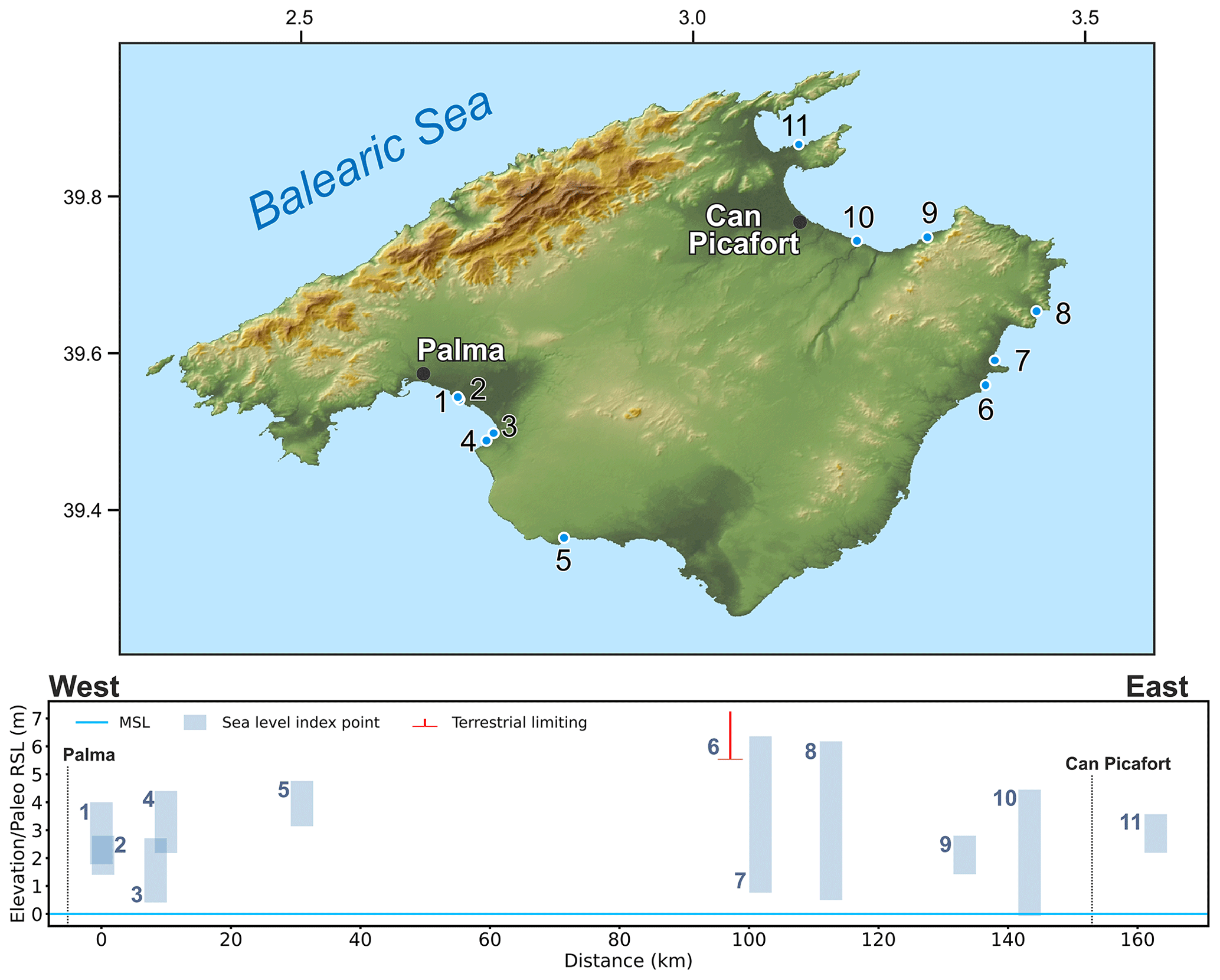
Figure 11MIS 5 sea-level data for Mallorca (Balearic Islands, Spain). Upper panel: map of sites. The topography has been obtained from the SRTM void-filled DEM (Farr et al., 2007, NASA dataset). Lower panel: distance/elevation graph, counterclockwise from west (left) to east (right). Sites list: 1: Cala Pudent (RSL ID 779); 2: Camp de Tir Unit U4 (RSL ID 357); 3: Cova Baixa (Son Grauet) (RSL ID 780); 4: Cala Blava (RSL ID 781); 5: Cala Pi (RSL ID 782); 6: S'Illot (RSL ID 784); 7: Cala Millor (RSL ID 785); 8: Canyamel (RSL ID 786); 9: Caló des Camps (RSL ID 787); 10: Torrent de Son Real (RSL ID 788); 11: Platja de Sant Joan (RSL ID 789).
7.1.4 Balearic Islands (Mallorca)
The island of Mallorca (Fig. 11) has arguably preserved some of the most prominent Last Interglacial sea-level proxies within the western Mediterranean, which have been studied since at least the late 1950s (Butzer and Cuerda, 1962; Cuerda, 1957). Stearns and Thurber (1965) reported U-series (obtained with alpha counting) ages on mollusk shells for 10 samples at different sites across the island. In particular, they concentrated on the Camp de Tir site (RSL ID 357, no. 2 in Fig. 11), which is also referred to in the literature as “Es Carnatge”. This outcrop, located close to the Palma airport, is a Pleistocene beach-rock deposit composed of different units that were described in several studies (Butzer and Cuerda, 1962; Cuerda, 1957; Hearty, 1987; Zazo et al., 2003; Bardají et al., 2009a). Several authors concentrated on establishing chronological constraints for the different units within the beach deposit at Camp de Tir (Fig. 12), with U series (Hillaire-Marcel et al., 1996; Muhs et al., 2015; Zazo et al., 2003) or amino acid racemization (Hearty et al., 1986a; Hearty, 1987).
An account of the history of investigations of the Camp de Tir outcrop (among others) is given in Vicens et al. (2012). Until very recently, the outcrop was divided into different units, which were classified as “Neotyrrhenian” (∼ 2 m a.s.l., MIS 5a) and “Eutyrrenian” (∼ 3 m a.s.l., MIS 5e) based on faunal content, U series on mollusks, and amino acid racemization. This apparent age difference was recently ruled out by Muhs et al. (2015), who dated several Cladocora sp. coral samples from the (supposed) MIS 5a unit at Camp de Tir and obtained ages spanning the range 112–119 ka. Based on these, the authors argued that the entire Camp de Tir outcrop was deposited in MIS 5e. Lorscheid et al. (2017) measured the elevation of a bioconstructed rim of vermetids close to the location where Cladocora corals were dated, gathering a paleo RSL elevation at Camp de Tir of 2.10±0.71 m a.s.l.
Camp de Tir is surely the best-described MIS 5e outcrop in Mallorca, but it is not the only one. Re-assessing sites reported in previous studies, Lorscheid et al. (2017) surveyed with differential GPS another 10 sites scattered across the island. Overall, the fixed biological indicators and beach deposits at these sites show a coherent picture of paleo RSL located at 2.9±0.8 m a.s.l. This estimate is in very good agreement with the indications of phreatic overgrowth on speleothems (Tuccimei et al., 2006, 2012), which would place MIS 5e sea level at 2.15±0.75 m a.s.l. (Polyak et al., 2018).
In WALIS, we inserted data for 11 sites (Fig. 11) in Mallorca as reported in Lorscheid et al. (2017), associating them with different ages as estimated at each site by previous authors. We did not include a second dataset reported by Lorscheid et al. (2017), namely, shore platforms measured at higher elevations than the fossil beach deposits, due to the lack of age constraints on these features. As mentioned above, MIS 5e in Mallorca was studied both on the open coasts and coastal caves, in the form of phreatic overgrowth on speleothems. The details of these latter indicators are reported in another WALIS compilation focussing on U series on cave deposits (Dumitru et al., 2020).
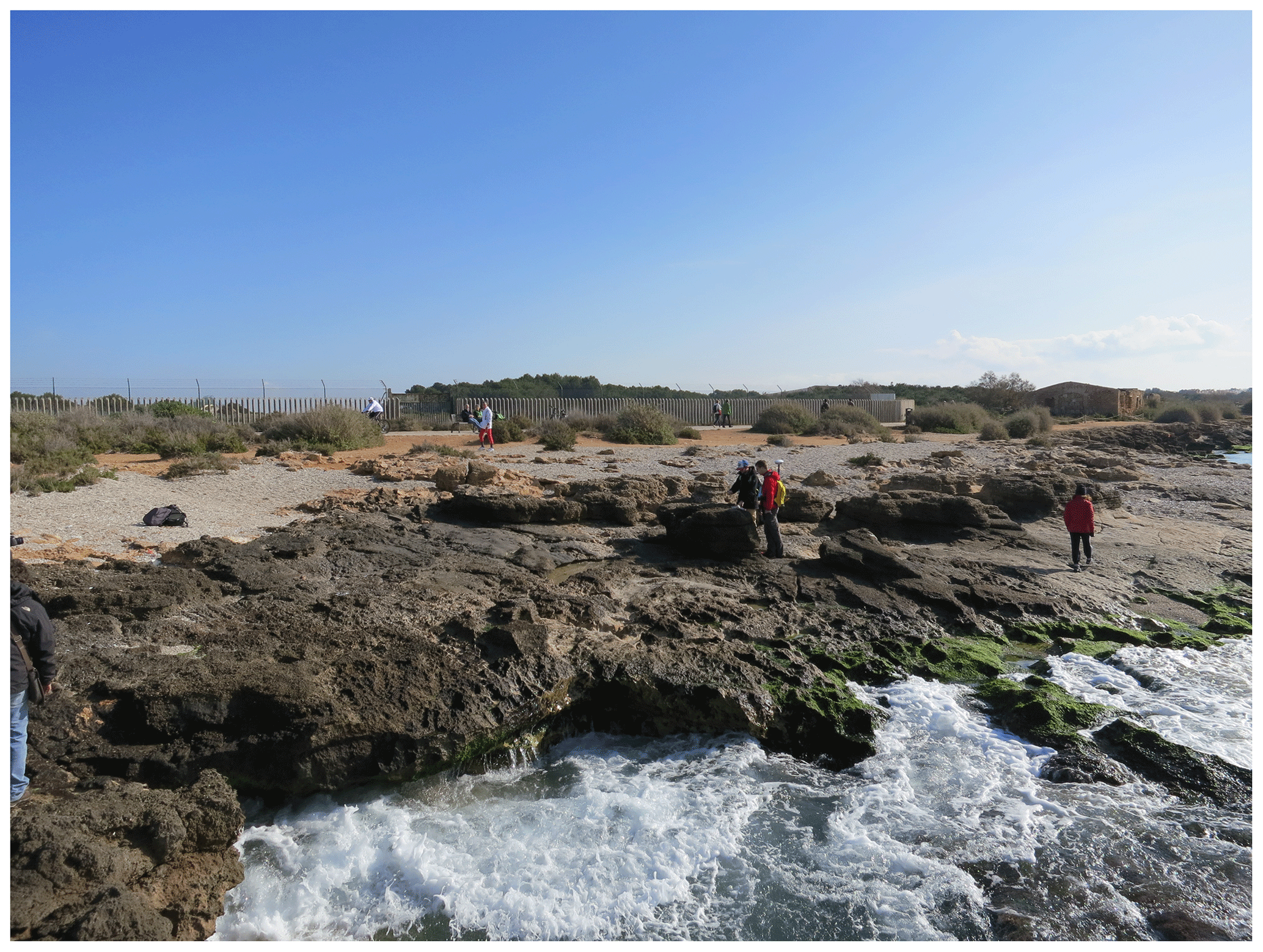
Figure 12General overview of the Camp de Tir outcrop in Mallorca (RSL ID 357, no. 2 in Fig. 11), Balearic Islands, Spain. The upper part of the outcrop is composed of shallow water beach sands of Last Interglacial age. Photo by Alessio Rovere.
7.2 Mainland France
The study of the marine Pleistocene deposits along the Mediterranean coast of France dates back to the 1950s (Masurel, 1953; Ottmann, 1954; Bonifay and Mars, 1959). The large majority of the literature is in French (Barrière, 1966; Ambert, 1999; Lumley et al., 2001; Provansal et al., 1995), while fewer studies have been published in English (Dubar et al., 2008; Stearns and Thurber, 1965). In general, the overall quality of the French data is significantly lowered by the dating constraints available. A large part of the marine deposits was dated using radiocarbon techniques in search of a mid-Holocene highstand that was not present in this portion of the Mediterranean (Vacchi et al., 2016). These ages (generally > 20 000 years) and the stratigraphic context of the outcrops suggest that the attribution to MIS 5 is reasonable, but further analysis with updated techniques is strongly needed, because only a few studies reported ages based on AAR or U Th dating.
7.2.1 Languedoc-Roussilion
The Languedoc-Roussilion coast extends from the border with Spain to the Rhône Delta (Fig. 13). Ambert (1999) compiled the most recent review of the Last Interglacial shorelines in this region. These are generally represented by beach deposits (sometimes cemented) found at different elevations not exceeding ∼ 8 m a.s.l. The beach deposits found near the towns of Narbonne (RSL ID 386, no. 4 in Fig. 13), Leucate (RSL ID 385 and 1316, nos. 1 and 2 in Fig. 13), and Port la Nouvelle (RSL ID 384, no. 3 in Fig. 13) are characterized by abundant faunal remains rich in Tapes dianae, which is considered the key species for the local “Euthyrrenian” stage. The single chronological constraint is provided by an ESR age on a shell collected at Port la Nouvelle which yielded an age of 128±15 ka (Yokoyama et al., 1987). Our re-analysis indicates that the maximal sea-level highstand in this portion of the French Mediterranean coast was placed at 6.4±2.5 m a.s.l. Ambert (1999) also reports a possible lower sea-level highstand which has been the result of a regressive phase following the maximal highstand. This was found near Leucate and is characterized by beach deposits at La Franqui (RSL ID 1316, no. 2 in Fig. 13) which placed the RSL at 3±2.5 m a.s.l. This deposit was dated with both radiocarbon and U Th techniques, but both ages were not considered reliable (Ambert, 1999); therefore, they only point to a minimum age (the deposit is older than Holocene). The faunal assemblage is also not very peculiar, with the sole presence of Spondylus gaederopus.
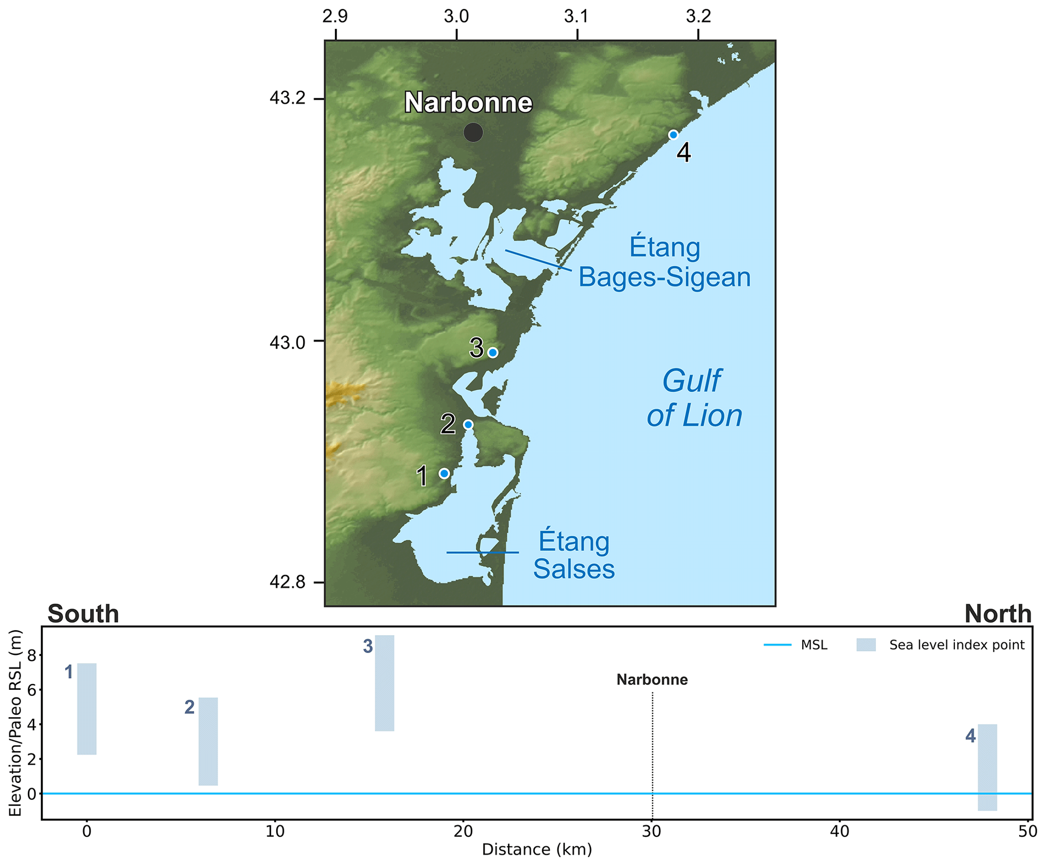
Figure 13MIS 5 sea-level data for Languedoc-Roussilion (France). Upper panel: map of sites. The topography has been obtained from the SRTM void-filled DEM (Farr et al., 2007, NASA dataset). Lower panel: distance/elevation graph, from south (left) to north (right). Sites list: 1: Leucate Le Malpas (RSL ID 385); 2: Leucate La Franqui (RSL ID 1316); 3: Port la Nouvelle Ramandils (RSL ID 384); 4: Narbonne Saint Pierre (RSL ID 386).
7.2.2 Provence-Côte d'Azur
This portion of the Mediterranean French coast extends from the Rhône Delta to the border with Italy (Fig. 14). In his review, Ambert (1999) reports a large elevation variability of the Last Interglacial shorelines which ranges from ∼ 3 to ∼ 22 m a.s.l. The lowest elevations of these shorelines are reported in the Marseille area. Here, the most robust indicator is represented by a lagoonal deposit sampled near the Étang de Berre (Provansal et al., 1995) which was used to reconstruct a paleo sea level placed at 3±1.4 m a.s.l. (RSL ID 387, no. 1 in Fig. 14). The late Pleistocene age of this deposit was provided by U Th dating on algae (U-series ID 795) which yielded ages ranging between 129 and 139 ka.
The majority of the data in the Provence-Côte d'Azur region were collected near the cities of Nice and Antibes (Dubar et al., 2008; Hearty et al., 1986a; Gilli, 2018). Stearns and Thurber (1965) firstly attempted to date the paleo shorelines found in this area. The U Th dating (U-series ID 2341) on mollusks found in beach deposits at ∼ 20 m a.s.l. in the Grotte de Lazaret yielded an age of 110±10 ka, while two other datings performed near Monaco on beach deposits found at very different elevations (U-series ID 2342 at ∼ 33.5 m a.s.l. and U-series ID 2343 at ∼ 1.8 m a.s.l.) yielded ages between 75 and 82 ka. This variability is likely related to issues of dating mixed shell remains with U series (Stearns and Thurber, 1965).
More recently, Dubar et al. (2008) performed some U Th dating (U-series IDs 1719 to 1725) on marine mollusk shells found in beach face deposits, which yielded MIS 5 ages. These deposits allowed reconstruction of a paleo sea level placed at 14±1.1 m a.s.l. (RSL ID 449, no. 3 in Fig. 14) and at 10.3±1.3 m a.s.l. (RSL ID 451, no. 4 in Fig. 14). The variability of the Last Interglacial shoreline in this area elevation was explained by differential tectonic uplift (Dubar et al., 2008). Gilli (2018) performed a U Th dating (U-series ID 1987) on a Cladocora caespitosa sample found in a living position at Cap d'Antibes. The coral, which yielded an age of 125±5 ka, constrains the paleo sea level above ∼ 6 m a.s.l. during MIS 5e.
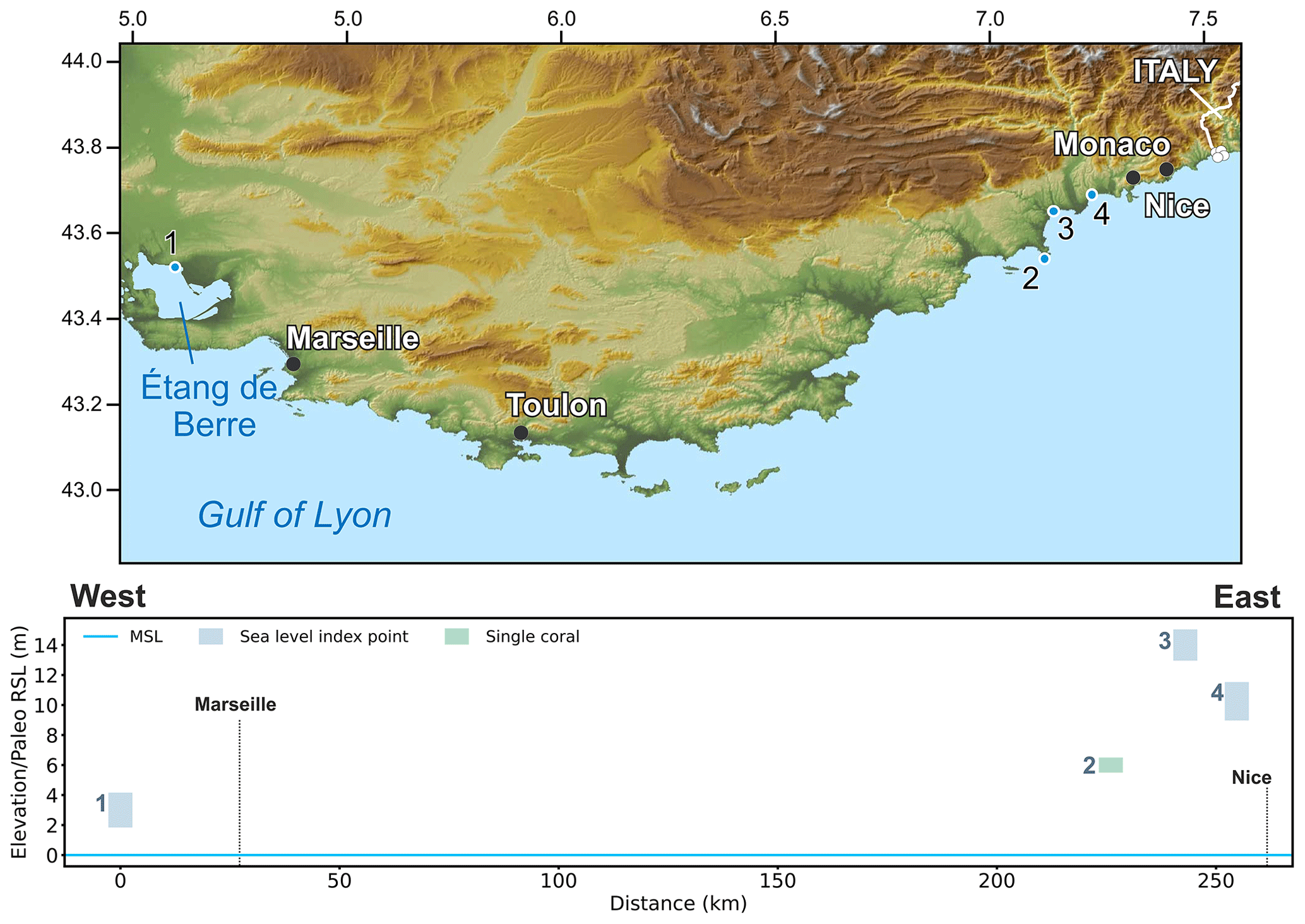
Figure 14MIS 5 sea-level data for Provence-Côte d'Azur (France). Upper panel: map of sites. The topography has been obtained from the SRTM void-filled DEM (Farr et al., 2007, NASA dataset). Lower panel: distance/elevation graph, from west (left) to east (right). Sites list: 1: Étang de Berre (RSL ID 387); 2: Cap d'Antibes (USeries_1988); 3: Nice Le Bosquet (RSL ID 449); 4: Nice Les Amandier (RSL ID 451).
7.3 Mainland Italy
The coasts of the Italian Peninsula (including the two main islands, Sardinia and Sicily) have preserved evidence of MIS 5 sea-level changes at several locations. These were the subject of previous Italian-wide compilations, namely, those of Bordoni and Valensise (1999) and Ferranti et al. (2006). In our work, we retrieved the original papers cited in these two papers whenever possible. When not possible, we retrieved the data reported by these compilations and inserted them into the WALIS template.
7.3.1 Liguria
East of the French border, Quaternary shorelines (in particular the Last Interglacial ones) are preserved at a few locations along the coast of Liguria (Fig. 15), mostly on limestone rocky coasts and in coastal caves. The most recent review on MIS 5e shorelines in this region was written by Federici and Pappalardo (2006), who analyzed several studies reporting RSL indicators. A few hundred meters from the French border, several sea-level indicators are present inside caves in an area called Balzi Rossi. Here, four caves (Ex Casino, Barma Grande, Bausu da Ture, Grotta del Principe, RSL IDs 233, 237, 239, 240, nos. 2, 4, 3, and 1, respectively, in Fig. 15) have preserved Last Interglacial deposits. Further to the east, similar deposits are found in the Madonna dell'Arma cave (RSL ID 242, no. 5 in Fig. 15) (Vicino, 1974; De Lumley, 1969; Isetti et al., 1962). This cluster of data was attributed to the Last Interglacial due to the presence of P. latus and Senegalese fauna and defines paleo RSL at an elevation of 7–12 m a.s.l. Similar deposits found in another marine cave (Grotta Marina di Bergeggi, RSL ID 246, no. 6 in Fig. 15) give a chronologic constraint to a well-preserved upper band of L. lithophaga (date mussel) boreholes (Fig. 16) at ∼ 6 m a.s.l. (Carobene, 2015). East of the city of Genoa there is only one outcrop that was attributed to the Last Interglacial by Federici and Pappalardo (2006), near the town of Lavagna. Here, a marine terrace at 28 m a.s.l. was dated with OSL at 139±11 ka. More recent ages confirmed that this deposit is older than MIS 5e (Marta Pappalardo, personal communication, 4 February 2021). Therefore, this data point has not been included in WALIS.

Figure 15MIS 5 sea-level data for Liguria (Italy). Upper panel: map of sites. The topography has been obtained from the SRTM void-filled DEM (Farr et al., 2007, NASA dataset). Lower panel: distance/elevation graph, from west (left) to east (right). Sites list: 1: Ex Casino (RSL ID 240); 2: Barma Grande (RSL ID 233); 3: Bausu da Ture (RSL ID 239); 4: Grotta del Principe (RSL ID 237); 5: Madonna dell'Arma (RSL ID 242); 6: Grotta Marina di Bergeggi (RSL ID 246).
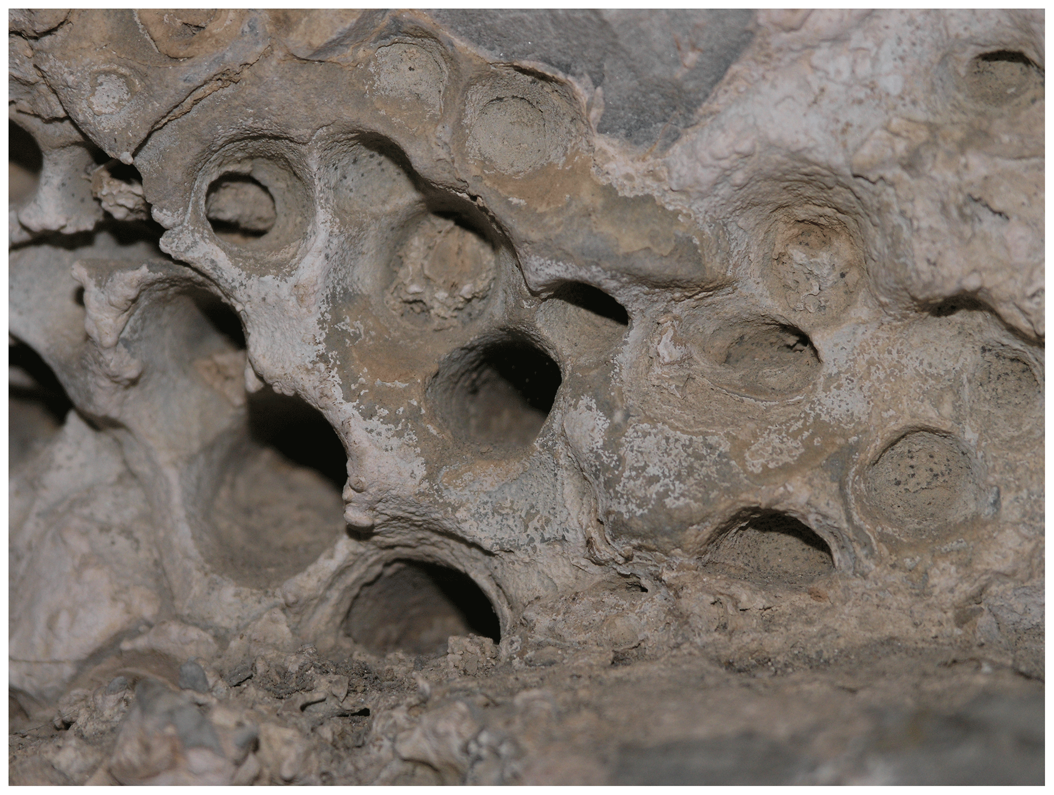
Figure 16Close-up of L. lithophaga boreholes at ∼ 6 m above modern sea level in the Grotta Marina di Bergeggi, Liguria, Italy (RSL ID 246, no.6 in Fig. 15). Each borehole has a diameter of approximately 2–3 cm. Photo by Alessio Rovere.
7.3.2 Tuscany
In Tuscany (Toscana), a relatively recent review of the Last Interglacial sea-level record was compiled by Nisi et al. (2003) starting from the compilation of Bordoni and Valensise (1999), which was later summarized and implemented with new information by Ferranti et al. (2006). As a result, many of the sites in our database were already included in Ferranti et al. (2006). Compared to this previous compilation, here we standardize the calculation of the indicative range for many of the previously reported sites, also re-analyzing original works (Fig. 17). We also report, where available, details on their dating. Starting from the north of Tuscany, we note that here we do not include in our database a core in the Versilia Plain. Within this core, coastal deposits found at 60 m b.s.l. were previously attributed to MIS 5e (Antonioli et al., 1999a), but more recently U Th dating on a Cladocora sp. coral collected from the same unit yielded an age of 195.7±1.6 ka (Carboni et al., 2010).
In the area of Livorno, Nisi et al. (2003) associated the Last Interglacial with the inner margin of a broadly developed marine terrace at elevations of 14 to 20 m a.s.l., referred to as the Terrazzo di Livorno (Livorno Terrace). A topographic sketch of the terrace of the site named Quercianella (RSL ID 255, no. 6 in Fig. 17, terrace elevation from Nisi et al. (2003) = 17 m a.s.l.) published by Boschian et al. (2006) shows that coastal deposits on the same terrace are found several meters below the inner margin (elevation of the “fossil beach” at Quercianella = ∼ 10 m a.s.l.) and that the elevation of the inner margin of the terrace is covered by fossil dunes and soils. For this reason, unless independent constraints were available on the elevation of coastal deposits, the inner margin of the terraces reported by Nisi et al. (2003) was considered in WALIS to be terrestrial-limiting. Zanchetta et al. (2004) describe several boreholes in the Livorno Terrace where coastal marine-cemented sands with shells are found at 5–10 m a.s.l. Summarizing previous studies, Ciampalini et al. (2006) clarify that these deposits are attributed to MIS 5e mostly based on the presence of Senegalese fauna.
The Livorno Terrace becomes narrower towards the south of Livorno (Boschian et al., 2006), where vertical or sub-vertical outcrops containing MIS 5e deposits were found. Mauz (1999) used OSL to date two sections, Buca dei Corvi (RSL IDs 325 and 326, nos. 7 and 8, respectively, in Fig. 17) and Baratti (RSL IDs 327 and 328, nos. 10 and 11, respectively, in Fig. 17), albeit obtaining only limiting ages (Buca dei Corvi > 10 ka, Baratti > 100 ka). These sections were already described and correlated with Aminozone E (assigned to MIS 5e) with amino acid racemization by Hearty et al. (1986a) and Hearty and Dai Pra (1987). The Buca dei Corvi outcrop is reported to contain Senegalese fauna and P. latus.
The same authors also reported similar deposits (with P. latus and assigned to Aminozone E) at Pianosa at Cala dei Turchi (RSL ID 330, no. 13 in Figs. 17 and 18), later also described by Antonioli et al. (2011). Here, the Aminozone E beach deposits (at 1.7 m a.s.l.) are in a close relationship with remnants of L. lithophaga boreholes and marine erosion at higher elevations (∼ 6 to 9 m a.s.l., RSL ID 331, no. 12 in Fig. 17) on the cliff. Stocchi et al. (2018) provide GPS measurements of these two features at Pianosa. These are reported in WALIS as separate entries, as it is not clear whether they were formed by one or two highstands, given the impossibility of giving separate age constraints to the L. lithophaga boreholes and erosional features on the cliff. The same issue applies to a tidal notch at Talamone (RSL ID 335, no. 14 in Fig. 17), which was recently measured by Antonioli et al. (2018) at 4.8 m a.s.l. The notch itself cannot be dated directly, but it was associated with nearby (2.7 km) deposits containing warm-water fauna at Campo Regio (RSL ID 336, no. 15 in Fig. 17, 6 m a.s.l., Hearty and Dai Pra 1987). Unfortunately, no AAR constraints are available at this site. South of the Orbetello lagoon, the Last Interglacial beach deposits were mapped by Hearty and Dai Pra (1987) at 10–13 m a.s.l. and attributed to MIS 5e with AAR.

Figure 17MIS 5 sea-level data for Tuscany (Italy). Upper panel: map of sites. Red dots are sites in the region of interest, and white dots are other sites within the western Mediterranean compilation. The topography has been obtained from the SRTM void-filled DEM (Farr et al., 2007, NASA dataset). Lower panel: distance/elevation graph, from north (left) to south (right). Sites list: 1: Casale Vallino (RSL ID 250); 2: Pian di Rota (RSL ID 251); 3: Bagnetti (RSL ID 252); 4: Antignano (RSL ID 253); 5: Punta Casotto (RSL ID 254); 6: Quercianella (RSL ID 255); 7: Buca dei Corvi BdC1 (RSL ID 325); 8: Buca dei Corvi BdC2 (RSL ID 326); 9: Rosignano Solvay (RSL ID 329); 10: Baratti Bar 1 (RSL ID 327); 11: Baratti Bar 2 (RSL ID 328); 12: Pianosa – Cala dei turchi 1 (RSL ID 331); 13: Pianosa – Cala dei turchi 2 (RSL ID 330); 14: Talamone (RSL ID 335); 15: Campo Regio (RSL ID 336); 16: Selva Nera (RSL ID 332); 17: San Angelino (RSL ID 334); 18: Vado Piano (RSL ID 333).
7.3.3 Lazio
The border between the Tuscany and Lazio (Latium) administrative regions (Fig. 19) is located in the Montalto coastal plain. Here, Hearty and Dai Pra (1987) identified and attributed to Aminozone E (corresponding to MIS 5e) several beach deposits, most of them containing Senegalese fauna. Some of these deposits were already known at the beginning of the last century (Gignoux, 1913; Blanc, 1935, 1936; Blanc and Segre, 1947, 1953; Segre, 1949; Bonadonna, 1967a, b; Radtke, 1986; Ozer et al., 1987; Palieri and Sposato, 1988; Milli and Zarlenga, 1991) and were successively reviewed by Bordoni and Valensise (1999), Nisi et al. (2003), and Ferranti et al. (2006).
These Last Interglacial beach deposits rise in elevation from the Tuscany–Lazio border towards the town of Tarquinia, reaching 25 m a.s.l. at the Aurelia km 103 site (RSL ID 483, no. 9 in Fig. 19). Towards the town of Tarquinia, the elevation of Last Interglacial beach deposits drops again to 13–16 m a.s.l. (RSL IDs 484, 479, and 480, nos. 10 to 12, respectively, in Fig. 19). Sixteen kilometers southwards, they rise to 35 m a.s.l. near Civitavecchia, at Monna Felice (RSL ID 494, no. 15 in Fig. 19). In the same area, ESR ages associated (in some cases) with facies descriptions of the deposits were reported by Radtke (1983) and Radtke (1986). While these two studies report several mollusk samples dated with ESR and U series on the stretch of coast between Civitavecchia and Monte Argentario, in the database only three sites were reported for which elevation, facies, and dating information is readily available (RSL IDs 4070, 4071, and 4072, nos. 7, 13, and 14 in Fig. 19).

Figure 18Shell-rich Last Interglacial deposit at Pianosa, Tuscany, Italy, at 1.7 m above the present sea level (RSL ID 330, no. 13 in Fig. 17). Photo by Alessio Rovere.
Hearty and Dai Pra (1986) report only two beach deposits dated to MIS 5e southwards, towards the city of Rome (RSL IDs 495 and 496, no. 16 and 17, respectively, in Fig. 19). At Cava Rinaldi (RSL ID 529, no. 18 in Fig. 19), Marra et al. (2016, 2019) dated a fluvial-lacustrine deposit (that we consider in the database to be a terrestrial-limiting point) at 26 m a.s.l. to MIS 5e (129±2 ka) with 40Ar 39Ar thanks to the presence of an intercalated pyroclastic-flow deposit. Fifty kilometers south of Rome, (Marra et al., 2019) dated one mollusk (Glycymeris sp.) with ESR and one coral (Cladocora sp.) with U series from a locality called Quadrato (RSL ID 527, no. 19 in Fig. 19) at 11 m a.s.l. The ESR sample gave an age of 79±7 ka, while the U-series one yielded an age of 198±8 ka, which was rejected due to a probable opening of the U Th system. Based on the ESR results and correlations of terrace levels across Lazio, Marra et al. (2019) conclude that MIS 5a peaked locally at 12 m a.s.l., MIS 5c at ∼ 23 m a.s.l., and that MIS 5e attained much higher levels, at around 35 m a.s.l. These conclusions are at odds with the attribution of similar deposits to Aminozone E (Hearty and Dai Pra, 1986, 1987). Also, two nearby sites (RSL IDs 497 and 498, nos. 20 and 21, respectively, in Fig. 19) were reported by Hearty and Dai Pra (1987) at roughly the same elevation and with similar stratigraphic characteristics of the Quadrato site attributed to Aminozone E and hence to MIS 5e.
Further to the south, in the Pontina Plain (RSL IDs 513 to 518, nos. 22 to 27 in Fig. 19), Antonioli et al. (1999b) reported lagoonal deposits in cores reaching several meters below the present sea level, again dated to Aminozone E. Similarly, in the Fondi Plain (south of the city of Latina), Antonioli et al. (1988) report MIS 5e deposits down to 6 m b.s.l. (RSL ID 508, no. 34 in Fig. 19). Last Interglacial sea-level indicators above the present sea level (such as beach deposits and tidal notches correlated with them) were instead reported in the headlands of Circeo, Terracina, Torre Capovento, Sperlonga, and Gaeta (Hearty and Dai Pra, 1986; Bordoni and Valensise, 1999; Ferranti et al., 2006; Antonioli et al., 2018). Within two caves, called Grotta dei Moscerini and Grotta Guattari, Marra et al. (2019, 2020) report that Schwarcz et al. (1991a, b) dated “backbeach” deposits a few meters above sea level to MIS 5a–MIS 5e. Within this study, it was possible to retrieve only the paper on Grotta Guattari by Schwarcz et al. (1991a), reporting that “the sedimentary fill of Grotta Guattari was deposited over a short interval, commencing soon after the retreat of sea level after stage 5 and terminating at about 57,000 years B.P.”. As it seems difficult to derive reliable sea-level information from similar indicators, we did not insert these data points into WALIS, pending further studies on these sites.
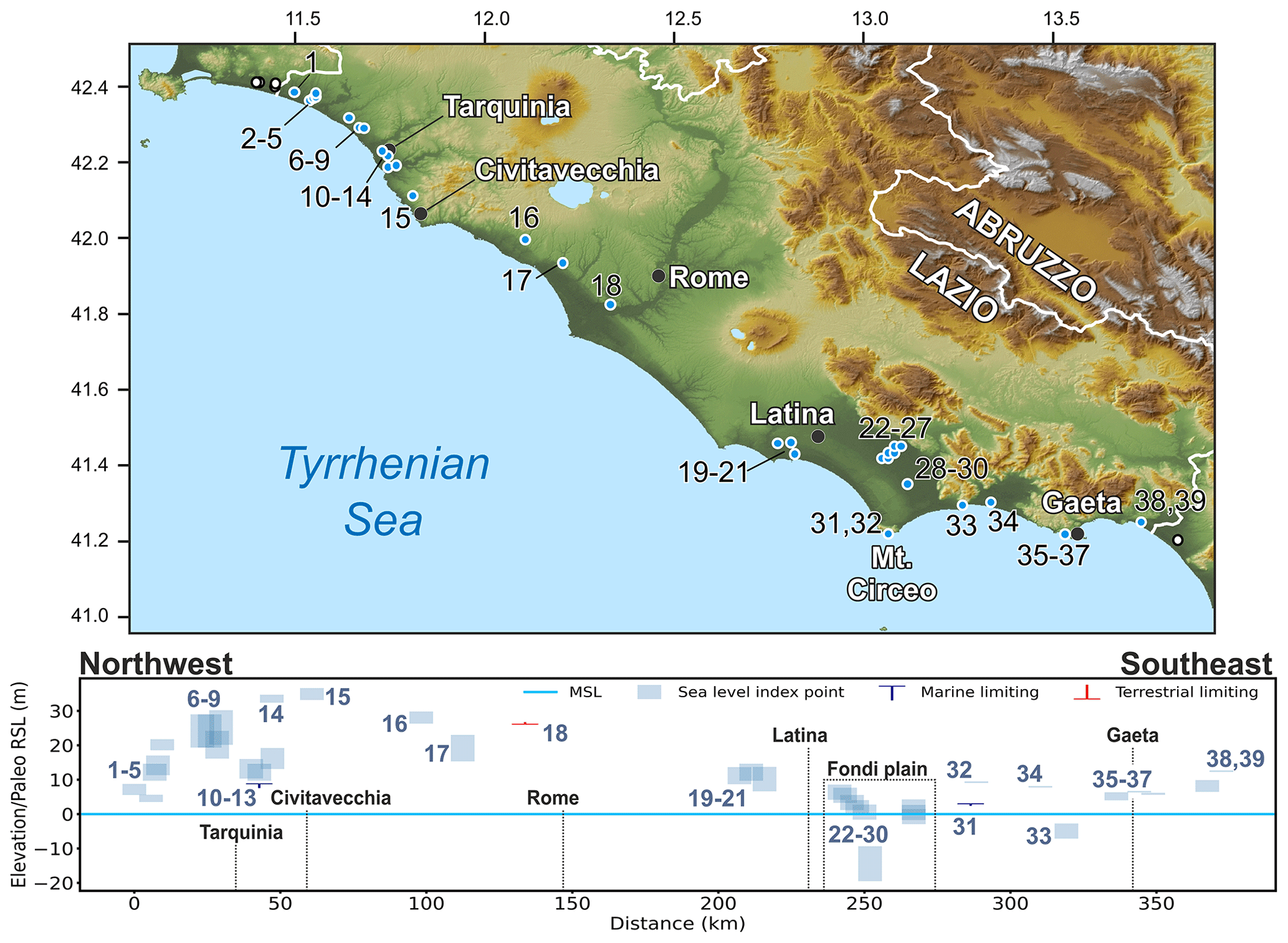
Figure 19MIS 5 sea-level data for Lazio (Italy). Upper panel: map of sites. Red dots are sites in the region of interest, and white dots are other sites within the western Mediterranean compilation. The topography has been obtained from the SRTM void-filled DEM (Farr et al., 2007, NASA dataset). Lower panel: distance/elevation graph, from northwest (left) to southeast (right). Sites list: 1: Lasco Del Pozzo (RSL ID 354); 2: Centrale Nucleare Montalto di Castro (RSL ID 475); 3: La Ficonaccia (RSL ID 476); 4: Ponte Rotto (RSL ID 477); 5: Km 115.5 (RSL ID 478); 6: Il Mandrione, right bank of Arrone River (RSL ID 482); 7: Riva dei Tarquini (RSL ID 4070); 8: Between Arrone and Mignone rivers (RSL ID 481); 9: Aurelia km 103 (RSL ID 483); 10: Northwest of Tarquinia railway station (RSL ID 484); 11: F. delle Serpe (RSL ID 479); 12: Casale Olivastro (RSL ID 480); 13: Km17-1(k) (RSL ID 4071); 14: Casal San Vincenzo (RSL ID 4072); 15: Monna Felice (RSL ID 494); 16: Monteroni – Cerveteri (RSL ID 495); 17: Casale di Statua (RSL ID 496); 18: Cava Rinaldi (point d) (RSL ID 529); 19: Quadrato (RSL ID 527); 20: Borgo Santa Maria, west of Latina (RSL ID 497); 21: Borgo Sabotino (RSL ID 498); 22: Pontinia I (RSL ID 513); 23: Pontinia II (RSL ID 514); 24: Pontinia III (RSL ID 515); 25: Pontinia IV (RSL ID 516); 26: Pontinia V (RSL ID 517); 27: Pontinia VI (RSL ID 518); 28: Borgo Vodice I (RSL ID 519); 29: Borgo Vodice II (RSL ID 520); 30: Borgo Vodice III (RSL ID 521); 31: Torre Rossa (RSL ID 499); 32: Circeo (Grotta delle Capre) (RSL ID 522); 33: Terracina (Pisco Montano) (RSL ID 523); 34: Fondi plain core ATP4 (RSL ID 508); 35: Torre Capovento (RSL ID 500); 36: Sperlonga (Sant'agostino) (RSL ID 524); 37: Gaeta (Grotta del Turco) (RSL ID 525); 38: Marina di Minturno (RSL ID 501); 39: Minturno (Monte d'Argento) (RSL ID 526).
7.3.4 Campania
South of Lazio, Last Interglacial sea-level records in Campania have been reported both from the subsurface (in the Garigliano and Campania coastal plains) and on surface outcrops (mainly along the Cilento promontory, Sele Plain, Sorrento Peninsula, and Capri) (Fig. 20). The most recent review on the Quaternary evolution of the Campania coastal plains was compiled by Santangelo et al. (2017). These authors reconstructed, with both previously published and new subsurface data, the distribution of a marine unit that was correlated with MIS 5e thanks to a U-series age on fragments of C. caespitosa (126±11 ka, U-series ID 1964) found in the San Marcellino core (RSL ID 722, no. 2 in Fig. 20, Romano et al., 1994; see below).
In the Garigliano Plain, at Masseria Transitiello (near Cellole Aurunci, RSL ID 3624, no. 1 in Fig. 20), Brancaccio et al. (1990) correlated biocalcarenites (AAR ID 168) outcropping at a few meters above sea level with a tidal notch at 8 m a.s.l. at Minturno-Monte D'Argento (RSL ID 526, no. 36 in Fig. 20; see the previous section). Six specimens of Glycimeris glycimeris from Masseria Transitiello have been dated with AAR, giving a D/L value (0.40±0.02) corresponding to Amminozone E, correlated with MIS 5e by Hearty and Dai Pra (1986). In the Campania Plain, MIS 5e marine deposits have been found at 50 m b.s.l. in the San Marcellino core (RSL ID 722, no. 2 in Fig. 20) (Romano et al., 1994).
Last Interglacial sea-level proxies were also found at ca. 18 m b.s.l. in the San Marco Evangelista core (Santangelo et al., 2010), near the city of Caserta, about 28 km inland from the modern coastline (RSL ID 739, no. 3 in Fig. 20). In this core, the deposits associated with the Last Interglacial transgression (labeled the Upper fossiliferous Unit) were constrained by the integration of tephra-stratigraphic and radiometric analyses (40Ar 39Ar) on volcanic layers. In particular, the Upper fossiliferous Unit (between 27 and 17.4 m b.s.l.) is located by Santangelo et al. (2010) between a tephra layer (Strat ID 65) at the top, which was correlated with an eruption dated 105 ka (Allen et al., 1999), and an older tephra at the bottom (WALIS Other Dating ID 53) dated (39Ar 40Ar on sanidine crystals) 150±10 ka.
Towards the southern edge of the Campania Plain (near the town of Sarno), MIS 5e proxies were reported by Cinque et al. (1987) and Barra et al. (1991) at 23 m b.s.l. (top of marine unit), constrained by U dating on C. caespitosa and the warm species Sylvestra seminis (RSL ID 790, no. 4 in Fig. 20). In the area close to the town of Cancello, towards the northeastern border of the Campania Plain, Romano et al. (1994) assigned a marine terrace at 50 m a.s.l. to MIS 5e, correlating it with the C. caespitosa dated at the San Marcellino core and described above. However, a recent work (Cerrone et al., 2021c) correlates the formation of this raised marine terrace with an older MIS, constrained by new U-series dating. This point was therefore not inserted into the database.
Last Interglacial sea-level proxies in the Sorrento Peninsula crop out mainly on the southern side at elevations comparable with those recorded in other tectonically stable areas of the Tyrrhenian Sea. In particular, at Cala di Ieranto (RSL ID 721, no. 29 in Fig. 20) and Conca dei Marini (RSL ID 720, no. 34 in Fig. 20), Brancaccio et al. (1978) dated C. caespitosa and mollusks to constrain the age of tidal notches at 7.5 m a.s.l. According to these authors, their sample C-2 (U-series ID 1955, on a mollusk shell) yields an age younger than the one obtained for the C. caespitosa as a consequence of uranium uptake, as confirmed by the high 234U 238U ratio. In Conca dei Marini, U-series dating and geomorphological investigations by Iannace et al. (2003) and Riccio et al. (2001) allowed us to identify three distinct Last Interglacial sea-level peaks, with a double notch at 6.5 m (RSL ID 766, no. 33 in Fig. 20) and ∼ 8 m a.s.l. (RSL ID 3565, no. 36 in Fig. 20) and another tidal notch at 3.5 m a.s.l. (RSL ID 767, no. 32 in Fig. 20). Moreover, Riccio et al. (2001) tentatively correlated with MIS 5a a tidal notch at 2 m a.s.l. at Conca dei Marini and clearly visible on the southern side of the Sorrento Peninsula (RSL ID 3623, no. 35 in Fig. 20). Such age estimation is supported by geomorphological correlation constrained on a date published by Brancaccio et al. (1978).
Ferranti and Antonioli (2007) measured the elevation of the Tyrrhenian tidal notch along the coast of Capri. The elevation of the notch varies between 5.2 and 8 m a.s.l., and it has been assigned an MIS 5e age by correlation with U-series ages on C. caespitosa from the bay of Ieranto, on the southern side of the Sorrento Peninsula (RSL IDs 800 to 822, nos. 6 to 28 in Fig. 20; see a photo of one of the notches in Fig. 21) (Brancaccio et al., 1978).
In the Sele coastal plain, Brancaccio et al. (1986, 1987) recognized and dated with AAR two marine deposits bearing Glycimeris glycimeris specimens. Based on such dating, the Gromola ridge site (up to 13 m a.s.l.) has been correlated with MIS 5c (RSL ID 770, no. 38 in Fig. 20) and the Ponte Barizzo ridge site, reaching an elevation of 25 m a.s.l., with MIS 5e (RSL 769, no. 37 in Fig. 20).
Many records of MIS 5e were reported at elevations ranging from 7–8 up to 10–15 m a.s.l. along the coasts of the Cilento promontory. These were assigned an MIS 5 age with AAR, U-series, and stratigraphic constraints (presence of P. latus). In particular, Brancaccio et al. (1990) dated marine deposits bearing Glycimeris glycimeris associated with the marine terraces of Ogliastro Marina (RSL ID 592, no. 42 in Fig. 20), Sapri (RSL ID 791 and 792, nos. 54 and 55 in Fig. 20), and Palinuro (Lido Ficocella, RSL ID 593, no. 43 in Fig. 20). The age provided from the Palinuro site is correlated with MIS 5. Also, the presence of P. latus fragments at elevations up to 2–3 m a.s.l. allowed Antonioli et al. (1994a) to correlate a tidal notch in the same elevation range along the Palinuro Cape (RSL ID 732, no. 44 in Fig. 20) with MIS 5e.
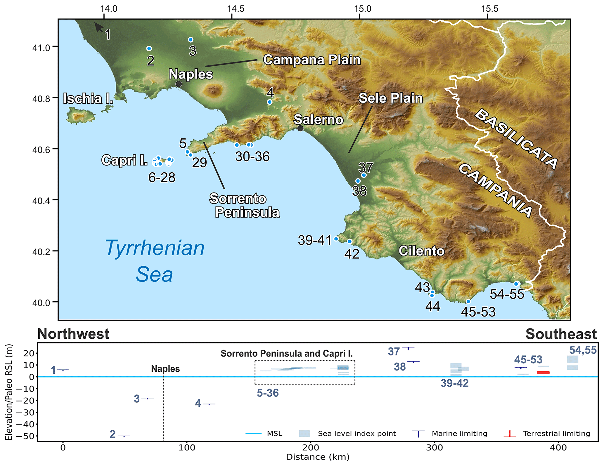
Figure 20MIS 5 sea-level data for Campania (Italy). Upper panel: map of sites. The topography has been obtained from the SRTM void-filled DEM (Farr et al., 2007, NASA dataset). Lower panel: distance/elevation graph, from northwest (left) to southeast (right). Sites list: 1: Cellole Aurunci Masseria Transitiello (RSL ID 3624); 2: San Marcellino well (RSL ID 722); 3: San Marco Evangelista (RSL ID 739); 4: Sarno well (RSL ID 790); 5: Mitigliano (RSL ID 3581); 6: Scoglio Ricotta (I) Capri (RSL ID 821); 7: Scoglio Ricotta (II) Capri (RSL ID 822); 8: Grotta Testa del Cavallo Capri (RSL ID 800); 9: Grotta Jannarella Capri (RSL ID 801); 10: P.ta Campitiello Capri (RSL ID 802); 11: Cala del Limmo Capri (RSL ID 803); 12: Cala Articola (II) Capri (RSL ID 805); 13: Cala Articola (I) Capri (RSL ID 804); 14: Cala Articola (III) Capri (RSL ID 806); 15: Grotta Verde (I) Capri (RSL ID 807); 16: Grotta Verde (II) Capri (RSL ID 808); 17: Gr. Belvedere Capri (RSL ID 809); 18: Gr. Fontolina Capri (RSL ID 810); 19: I Faraglioni Capri (RSL ID 811); 20: Porto di Tragara (I) Capri (RSL ID 812); 21: Porto di Tragara (II) Capri (RSL ID 813); 22: P.ta di Masullo Capri (RSL ID 814); 23: a vascio funno Capri (RSL ID 815); 24: Cala Matermiana Capri (RSL ID 816); 25: Gr. Bianca (I) Capri (RSL ID 817); 26: Gr. Bianca (II) Capri (RSL ID 818); 27: P.ta della Chiavica Capri (RSL ID 819); 28: P.ta del Monaco Capri (RSL ID 820); 29: Cala di Ieranto (RSL ID 721); 30: Vettica Maggiore (RSL ID 823); 31: Grotta dello Smeraldo (RSL ID 798); 32: Conca dei Marini (III) Site I (RSL ID 767); 33: Conca dei Marini (II) Site I (RSL ID 766); 34: Conca dei Marini (I) Site I (RSL ID 720); 35: Conca dei Marini (V) (RSL ID 3623); 36: Conca dei Marini (IV) Site I (RSL ID 3565); 37: Ponte Barizzo (RSL ID 769); 38: Gromola (RSL ID 770); 39: Licosa Cape (III) (RSL ID 728); 40: Licosa Cape (II) (RSL ID 727); 41: Licosa Cape (I) (RSL ID 726); 42: Ogliastro Marina Baia Arena (RSL ID 592); 43: Palinuro Lido Ficocella (RSL ID 593); 44: Palinuro Cape (RSL ID 732); 45: The Riparo Infreschi cave (I) (RSL ID 3568); 46: The Riparo Infreschi cave (II) (RSL ID 3569); 47: The Riparo Infreschi cave (III) (RSL ID 3570); 48: The Riparo Infreschi cave (VI) (RSL ID 3573); 49: The Riparo Infreschi cave (IX) (RSL ID 3576); 50: The Riparo Infreschi cave (VIII) (RSL ID 3575); 51: The Riparo Infreschi cave (VII) (RSL ID 3574); 52: The Riparo Infreschi cave (V) (RSL ID 3572); 53: The Riparo Infreschi cave (IV) (RSL ID 3571); 54: Sapri (II) (RSL ID 792); 55: Sapri (RSL ID 791).
Between Ogliastro Marina (Licosa Cape) and Agropoli, Cinque et al. (1994) recognized a flight of marine terraces and related the three lowest ones to the three peaks of MIS 5. This chronological attribution was confirmed by Iannace et al. (2001) using U-series dating on coralline algae. In this area, the marine terrace at 1.5 m a.s.l. is related to MIS 5a and the one at 5 m a.s.l. to MIS 5c, and two distinct terraces at 9 and 6.6 m a.s.l. have been assigned an MIS 5e age.
A detailed morpho-stratigraphic analysis based on a cross-cut relationship and Th/U age on speleothems allowed Esposito et al. (2003) to identify MIS 5c and 5a sea-level proxies in the Cava/Riparo degli Infreschi at 8.5 and 3.5 m a.s.l., respectively. However, recent works by Bini et al. (2020) reported no evidence of MIS 5c and MIS 5a, proposing a different paleoenvironment reconstruction of the Riparo degli Infreschi outcrop (RSL IDs 3568 to 3576, nos. 45 to 53 in Fig. 20) based on new U-series dating and tephra correlations. The new U-series dates were performed on speleothems and calcite-filled L. lithophaga boreholes; since such materials take shape above sea level, they have been included in the database as terrestrial-limiting. The top of L. lithophaga boreholes, measured at 8.9 m a.s.l. inside the Riparo degli Infreschi, has been correlated with MIS 5e (RSL ID 3568, no. 45 in Fig. 20).
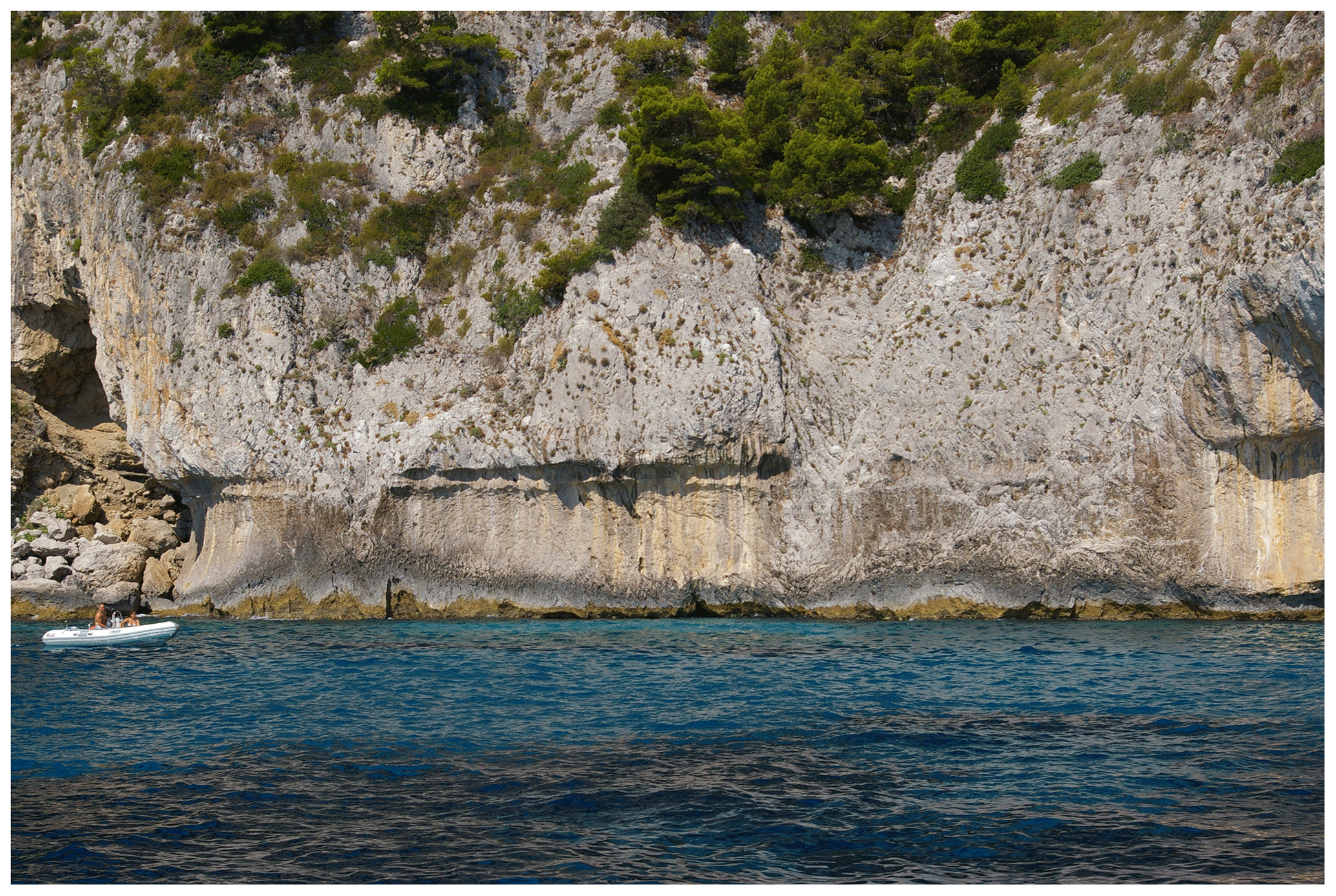
Figure 21Tidal notch at Capri, a Vascio Funno site (RSL ID 815, no. 23 in Fig. 20). Photo by Alessandra Ascione.
7.3.5 Basilicata and Calabria, Tyrrhenian side
The Last Interglacial sea-level proxies on the Tyrrhenian seaside of Basilicata have been attributed to the marine terraces up to ∼ 8–10 m a.s.l. (Fig. 22) from Fiumicello to Castrocucco (Carobene et al., 1986; Carobene and Dai Pra, 1991) and the northern Calabria coast from Castrocucco to nearby Cetraro (Torre la Testa, Carobene et al., 1986; Carobene and Dai Pra, 1990). Such interpretation is based on a geomorphological correlation derived from the identification of the Middle–Late Pleistocene terraces, which have been constrained by U-series and AAR dating on C. caespitosa and Bivalvia, respectively. However, a recent work by Cerrone et al. (2021a) rejected such dating and reconstructed the evolution of the area spanning from Fiumicello (Basilicata) to Scalea (Calabria), providing new U-series dating on the marine deposits (biocalcarenites bearing C. caespitosa corals) associated with the marine terraces corresponding to MIS 5a, 5c, and 5e, which reach up to some tens of meters in elevation. These data are not yet included in WALIS.

Figure 22MIS 5 sea-level data for the Tyrrhenian side of Calabria and Basilicata (Italy). Upper panel: map of sites. The topography has been obtained from the SRTM void-filled DEM (Farr et al., 2007, NASA dataset). Red dots are sites in the region of interest, and white dots are other sites within the western Mediterranean compilation. Lower panel: distance/elevation graph, from northeast (left) to southwest (right). Sites list: 1: Vibo Marina (RSL ID 267); 2: Paradisoni (RSL ID 315); 3: Sacco (RSL ID 316); 4: Briatico (RSL ID 268); 5: Capo Vaticano (RSL ID 269); 6: Nicotera (RSL ID 270); 7: Gioia Tauro Contrada Iannì (nearby Nicotera) (RSL ID 3431); 8: Gioia Tauro basin (RSL ID 3430); 9: Rosarno (RSL ID 314); 10: Ravagnese (RSL ID 304); 11: Trombaca (RSL ID 312); 12: Bovetto (RSL ID 306); 13: Trombaca II (RSL ID 4065); 14: Traietta (RSL ID 4066); 15: Rione Branca (RSL ID 4067); 16: Nocella Pellaro (RSL ID 1378); 17: Nocella II (RSL ID 4062); 18: Altibano (RSL ID 313).
The promontory of Capo Vaticano (RSL IDs 267 to 270, 314 to 316, 3430, and 3431, nos. 1 to 8 in Fig. 22) has been deeply investigated in the last decades, and many dating constraints (OSL, TL, and U series) have been provided. However, a debate on the age and spatial distribution of the marine terraces of the area is still open due to the complexity of the structural setting. Bianca et al. (2011) performed OSL dating on unconsolidated sandy layers associated with marine terraces and correlated with MIS 5c the marine terrace at 50 m a.s.l. in Vibo Marina. The MIS 5c terrace of Bianca et al. (2011) reaches 175 m a.s.l. at Capo Vaticano (RSL ID 269, no. 5 in Fig. 22). Such correlation is strengthened by TL dating by Balescu et al. (1997). However, Pata (1947) reported P. latus specimens within the +50 m a.s.l. terrace in Vibo Marina (RSL ID 267, no. 1 in Fig. 22), which allowed Dai Pra et al. (1991), Dumas et al. (1991), and Roberts et al. (2013) to consider such a terrace to be of MIS 5e age. The last interpretation is supported by Roberts et al. (2013) based on U-series dating (U-series IDs 2665 and 2666) and by the use of a synchronous correlation method.
In the Reggio Calabria area, Gignoux (1913) reported the presence of P. latus and Senegalese fauna in the Bovetto (RSL ID 306, no. 12 in Fig. 22) and Ravagnese areas (RSL ID 304, no. 10 in Fig. 22) at elevations up to ∼ 130 m a.s.l. This area was later investigated by Hearty et al. (1986a, b), Dumas et al. (1987, 1988), and Balescu et al. (1997), who dated the deposits with AAR and TL to MIS 5e. Another terrace, at Altibano (RSL ID 313, no. 18 in Fig. 22), was tentatively correlated by Balescu et al. (1997) with MIS 5e, while according to Dumas et al. (1988) and Dumas et al. (1987) the same terrace was formed before the Last Interglacial. In Nocella (Fig. 22), Dumas et al. (1987) report the highest occurrence of P. latus along the whole Mediterranean coast at 157 m a.s.l. This point has been related to a marine terrace reaching up to 166 m a.s.l. (RSL ID 1378, no. 16 in Fig. 22). It is worth noting that Dumas et al. (1988) report the presence of P. latus at 105 m a.s.l. (RSL ID 4062, no. 13 in Fig. 22) and 157 m a.s.l. in Nocella. These elevations are correlated with two distinct paleo shorelines (labeled VI and VII in Dumas et al., 1988) that were both associated with MIS 5e by the original authors. The authors hypothesized that these paleo shorelines correspond to two different peaks of MIS 5e. However, in doing this, they raise an elevation gap problem that is not easy to justify. The age of these two paleo shorelines (VI and VII in Nocella) could not be differentiated by AAR geochronology (Dumas et al., 1988) or TL (Balescu et al., 1997). The issue, hence, is still open. The Bovetto–Ravagnese, Nocella, and Altibano terraces are geomorphologically separated, but their chronological order cannot be easily untangled. However, based on the available data, and in particular considering as a key spot the Bovetto–Ravagnese terrace, an uplift rate of ∼ 1 mm yr−1 for the Last Interglacial may be calculated for this area (Dumas et al., 1987, 1988; Ferranti et al., 2006).
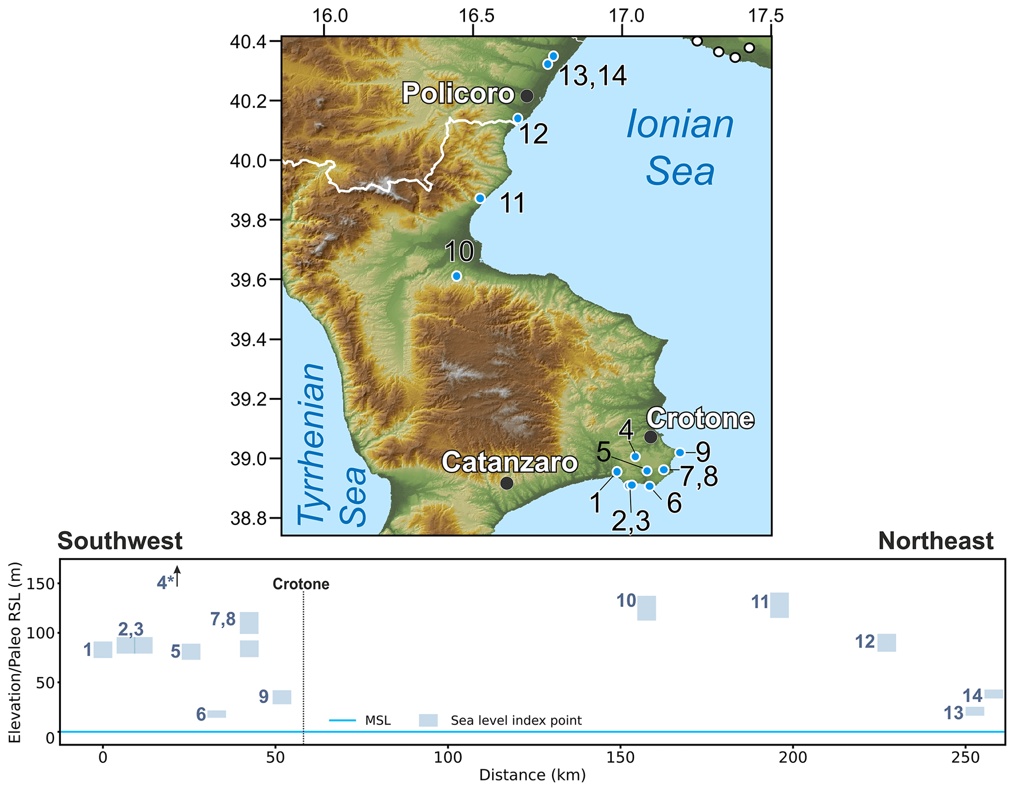
Figure 23MIS 5 sea-level data for the Ionian side of Calabria and Basilicata (Italy). Upper panel: map of sites. Red dots are sites in the region of interest, and white dots are other sites within the western Mediterranean compilation. The topography has been obtained from the SRTM void-filled DEM (Farr et al., 2007, NASA dataset). Lower panel: distance/elevation graph, from southwest (left) to northeast (right). Sites list: 1: San Leonardo di Cutro (RSL ID 563); 2: Campolongo (RSL ID 4068); 3: Le Castella (RSL ID 4069); 4: Manca della Mozza (RSL ID 566, out of bounds at 240 m a.s.l., dated to Marine Isotope Stage 7); 5: Isola di Capo Rizzuto (RSL ID 565); 6: Capo Rizzuto (RSL ID 564); 7: Crotone (II) (RSL ID 3428); 8: Crotone (RSL ID 1379); 9: Capo Colonna Terrace (RSL ID 3634); 10: Vaccarizzo (RSL ID 442); 11: Trebisacce (RSL ID 324); 12: Piano San Nicola (RSL ID 416); 13: Metaponto (RSL ID 4060); 14: Metaponto (II) (RSL ID 4061).
7.3.6 The Ionian coast of Calabria and Basilicata
Along the Ionian Sea coasts of Calabria and Basilicata (Fig. 23) we identified several studies reporting the presence of Last Interglacial shorelines. The Pleistocene marine terraces in Crotone and Isola di Capo Rizzuto (RSL IDs 563 to 565, 1379, 3428, nos. 1, 6, 5, 8 and 7 in Fig. 23) were first reported by Cortese (1895) and have been studied in detail by successive authors (Gignoux, 1913; Cosentino and Gliozzi, 1988; Belluomini et al., 1988; Selli, 1962; Palmentola et al., 1990; Mauz and Hassler, 2000; Ruggieri, 1948; Zecchin et al., 2009; Nalin and Massari, 2009, among others). The Crotone Peninsula has been considered the “locus typicus of the Crotonian stage” (Belluomini et al., 1988, and references therein), i.e., an area where the Middle Pleistocene is particularly well-represented. The most recent review of RSL indicators in the Crotone Peninsula is contained in Nalin et al. (2020), who also provided new infrared-stimulated luminescence dating. The MIS 5e marine terrace in this area has been traced up to ∼ 80–110 m a.s.l. and was dated with AAR (Belluomini et al., 1988) and TL (Mauz and Hassler, 2000). Based on such dating, the Capo Colonna Terrace (RSL ID 3634, no. 9 in Fig. 23) has been correlated with MIS 5 thanks to the presence of deposits with P. latus (Nalin et al., 2012; Palmentola et al., 1990). An AAR age of these deposits points to MIS 5a (AAR ID 161). New findings of P. latus at the Crotone Peninsula were reported by Bracchi et al. (2011) and Nalin et al. (2012) in addition to those already reported in the Campolongo area (Gliozzi, 1987) and in Bosco Soverito (Palmentola et al., 1990). These sites have not been included in the database, as there is not enough information to derive RSL index points. The age provided to constrain the Isola di Capo Rizzuto site (RSL ID 565, no. 5 in Fig. 23) may be interpreted as a minimum age due to saturation problems of quartz and feldspar minerals. In Nalin et al. (2020) it is reported as MIS 7.
In Trebisacce (RSL ID 324, no. 11 in Fig. 23), at the northern border of the Sibari coastal plain, Cucci (2004) dated to MIS 5e (AAR IDs 97 and 98) a marine terrace at 128 m a.s.l. The elevation of the MIS 5e marine terrace mapped by Cucci (2004) between Trebisacce and Lauropoli spans in elevation between 145 and 115 m a.s.l. In the database, only the inner edge of the marine terrace corresponding to the Trebisacce site has been included, this being the only location where a direct age constraint has been provided. A few kilometers northeast of Trebisacce, in Vaccarizzo (RSL ID 442, no. 10 in Fig. 23), Santoro et al. (2009) constrained the MIS 5e marine terrace at 125 m a.s.l. by ESR dating on Cardium sp. (ESR ID 100).
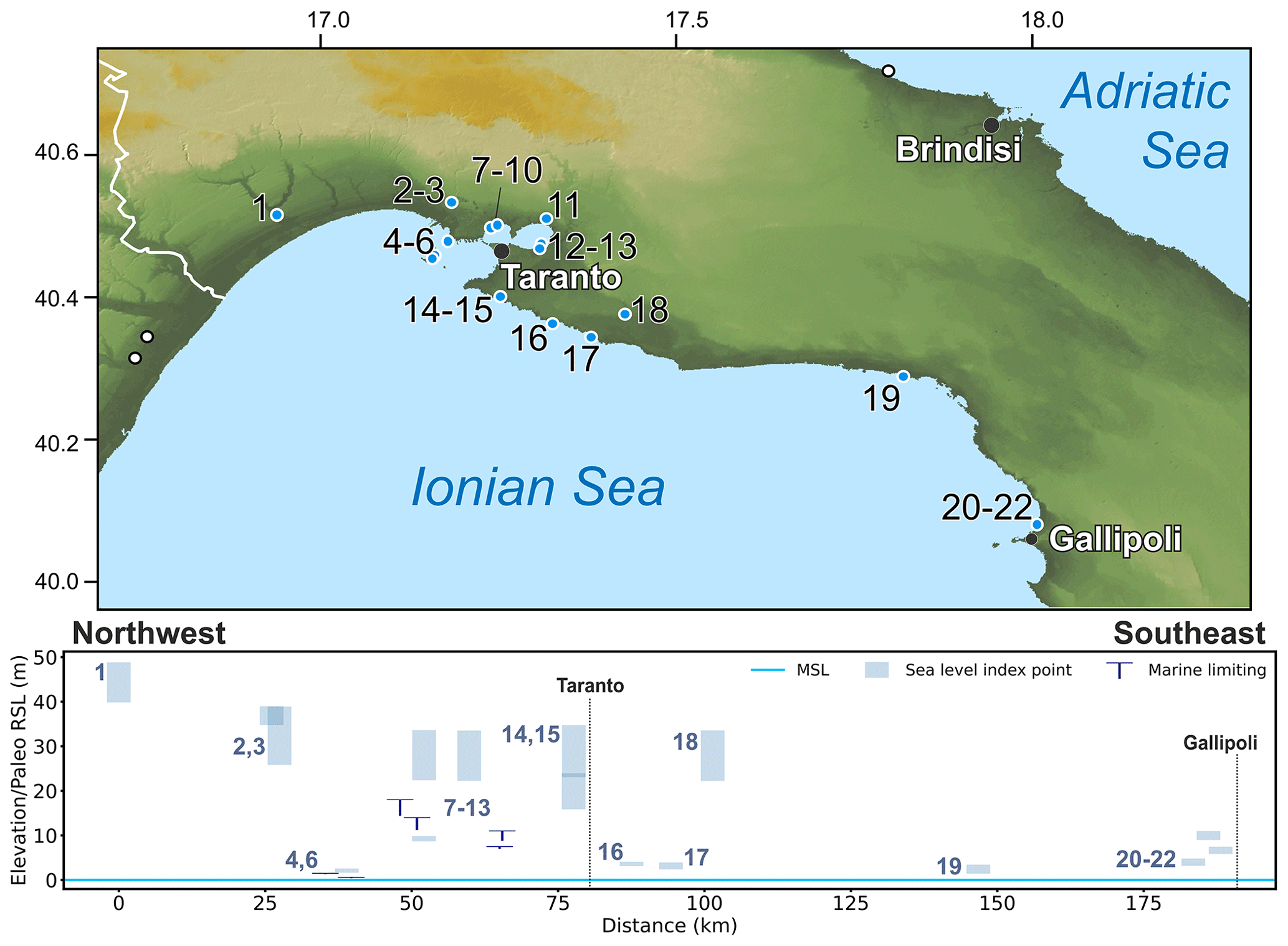
Figure 24MIS 5 sea-level data for the Ionian side of Apulia (Italy). Upper panel: map of sites. Red dots are sites in the region of interest, and white dots are other sites within the western Mediterranean compilation. The topography has been obtained from the SRTM void-filled DEM (Farr et al., 2007, NASA dataset). Lower panel: distance/elevation graph, from northwest (left) to southeast (right). Sites list: 1: Ponte del Re (RSL ID 355); 2: Ponte Romano Taranto (RSL ID 3631); 3: Masseria S. Giovanni Taranto (RSL ID 697); 4: Punta Rondinella (RSL ID 224); 5: Punta lo Scanno (RSL ID 225); 6: Apodonia (RSL ID 228); 7: Masseria Ruggiero Taranto (RSL ID 3632); 8: Masseria Bagnara (RSL ID 704); 9: Masseria Santa Teresiola (RSL ID 223); 10: Masseria Santa Teresiola (II) (RSL ID 3630); 11: Masseria San Pietro (RSL ID 699); 12: Il Fronte (RSL ID 230); 13: Masseria Pantaleo (RSL ID 701); 14: Carelli Between Carelli and Saturo harbour (RSL ID 698); 15: Il Posto Between Il Posto and Torre Castelluccia (RSL ID 700); 16: Punta della Baracca (RSL ID 226); 17: Torre Castelluccia (RSL ID 705); 18: Lizzano (RSL ID 695); 19: Torre Castiglione (RSL ID 696); 20: Torre Sabea Gallipoli (RSL ID 3625); 21: Gallipoli (RSL ID 3627); 22: Torre San Giovanni Gallipoli (RSL ID 3628).
Even if a very well-developed staircase of marine terraces (decreasing in elevation towards the northeast) crops out along the Ionian coast of Basilicata, their age is poorly constrained. In Piano San Nicola (RSL ID 416, no. 12 in Fig. 23), near the town of Nova Siri, the marine terrace, whose inner edge was reported at 90 m a.s.l., was correlated with MIS 5c or 5a by AAR dating (Dai Pra and Hearty, 1988). An MIS 5e terrace at the same site has been identified based on geomorphological correlation. However, as no age constraints have been provided for the terrace, it is not included in the database.
The Metaponto area has been studied since the works of Gignoux (1913, 1960) and Vezzani (1967), with several interpretations proposed regarding the age and number of the marine terraces forming the flight sequence in the northern part of the Taranto Gulf. Brückner (1980) identified 11 marine terrace orders, which were constrained by integration of magnetostratigraphy, tephrostratigraphy, and U-series dating on mollusks. According to Brückner (1980), Terrace T1 (up to 22 m a.s.l.) is correlated with MIS 5a (RSL ID 4060, no. 13 in Fig. 23), and Terrace T2 (up to 42 m a.s.l.) is correlated with MIS 5e (RSL ID 4061, no. 14 in Fig. 23). Such an interpretation is further supported by Zander et al. (2006) and Sauer et al. (2010) based on OSL and soil analyses. The correlation of Terrace T2 with MIS 5e is confirmed by correlation with the Ponte del Re site (RSL ID 355, no. 1 in Fig. 24), in Apulia, constrained via AAR and deposits with P. latus.
7.3.7 Apulia
Along the Ionian coasts of Apulia (Puglia) (Fig. 24), near the border with Basilicata, at the Ponte del Re-Castellaneta site (RSL ID 355, no. 1 in Fig. 24), a marine terrace up to 40 m a.s.l. was correlated with MIS 5 due to the presence of Senegalese fauna with P. latus (Boenzi et al., 1985). The correlation was later detailed to MIS 5e by AAR dating on marine deposits bearing Glycymeris (Dai Pra and Hearty, 1988). Eastwards of this site, in the Taranto area and Chéradi Islands, several outcrops were studied for nearly 1 century (Gignoux, 1913; Cotecchia et al., 1969; Hearty and Dai Pra, 1992; Gigout, 1960, 1962; Verri and De Angelis D'Ossat, 1899; Richetti, 1967; Caldara, 1987). These deposits are characterized by the widespread presence of P. latus, Senegalese fauna, and C. caespitosa corals (RSL IDs 223 to 226, 228, 230, 355, 695 to 705, and 3630 to 3632, nos. 9, 4, 5, 16, 6, 12, 1, 18, 19, 3, 14, 11, 15, 13, 8, 17, 10, 2, and 7, respectively, in Fig. 24) that confirm their MIS 5 age.
In particular, the section cropping out at Il Fronte (RSL ID 230, no. 2 in Fig. 24, near the city of Taranto) was recently analyzed in detail for stratigraphy, chronology, sedimentology, and paleoecological aspects, highlighting the possibility of using this place as a Global Stratotype Section and Point (GSSP) (Amorosi et al., 2014). The outcrop of Il Fronte site consists of an 8.5 m-thick succession made up of five marine units. Detailed facies analyses integrated with sequence stratigraphy and U-series dating allowed Amorosi et al. (2014) to reconstruct in detail sea-level fluctuations during MIS 5e at Il Fronte site. In particular, the base of the succession is characterized by nearshore deposits which evolve upwards to inner-shelf and middle–outer-shelf deposits. The MIS 5 coastline elevation in this area was traced by Dai Pra and Stearns (1977) up to 35 m a.s.l. in Ponte Romano (RSL ID 3631, no. 2 in Fig. 24).
South of Taranto, specimens of P. latus were reported in Torre Castelluccia (RSL ID 705, no. 17 in Fig. 24), in Torre Castiglione (RSL ID 696, no. 19 in Fig. 24), and near Gallipoli. At Torre Castelluccia, a pocket beach at 3 m a.s.l. has been constrained to Aminozone C (Dai Pra and Hearty, 1988, MIS 5a according to Hearty and Dai Pra, 1992), while deposits containing P. latus were located at 28 m a.s.l. in the surroundings of Lizzano (RSL ID 695, no. 18 in Fig. 24). The MIS 5e terrace in Torre Castiglione (RSL ID 696, no. 19 in Fig. 24) has been reported at 2.5 m a.s.l. (Dai Pra and Stearns, 1977). Moreover, at Gallipoli (RSL IDs 3625, 3227, and 3628, nos. 20 to 22 in Fig. 24), Glycimeris specimens sampled at 8–10 m a.s.l. were constrained with AAR to MIS 5e (Dai Pra and Hearty, 1988).
Towards the Adriatic Sea side of Apulia (Fig. 25), at the bottom of Grotta Romanelli (RSL ID 1319, no. 3 in Fig. 25), a marine deposit containing Senegalese fauna (elevation between 7 and 8 m a.s.l.) was correlated with MIS 5 (Blanc, 1920, 1928; Cosentino and Gliozzi, 1988). Mastronuzzi et al. (2007), though, report that these deposits do not contain P. latus, as reported by earlier works. The same authors studied a series of sea caves along the southern coasts of Salento, at elevations from 0 up to 10 m a.s.l. (RSL IDs 1319, 1320, 1323 and 1324, and 3635, nos. 3, 4, 2, 1 in Fig. 25). Based on stratigraphic correlations and U-series dating of flowstones, Mastronuzzi et al. (2007) argue that these caves were reshaped by the sea during MIS 9c, MIS 5e, and MIS 5a. We included in the database only the speleothem (U-series ID 2958) providing a limiting age (younger than 77 ka) at 3 m a.s.l. at Grotta del Diavolo (RSL ID 3635, no. 1 in Fig. 25) because the other samples of Mastronuzzi et al. (2007) were dated to older than MIS 5. Overall, according to the evolution modeling proposed by Mastronuzzi et al. (2007), the fact that these sea caves were reshaped by the sea during MIS 5e is proof of the tectonic stability of the area. In this context, the data points reported in Ferranti et al. (2006) from Parroni and Silenzi (1997), placing a marine terrace at an elevation of 25±15 m a.s.l. in Marina di Novaglie (RSL IDs 1323 and 1324, nos. 2 and 3 in Fig. 25), would need to be re-assessed with more precise measurements and dating to assess whether their attribution to MIS 5 is correct.
In the Apulian Tavoliere Plain, the dating of Glycymeris sp. with AAR from the MM4 borehole (De Santis et al., 2010) allowed us to include in the database three marine-limiting data points (RSL IDs 452 to 454, nos. 8 to 10 in Fig. 25). North of the Gargano promontory, near Ripalta at the mouth of the Fortore River floodplain, Bordoni and Valensise (1999) tentatively associated the coastal plain at 25 m a.s.l. with MIS 5e based on the dating of the lower Holocene plain (Mastronuzzi et al., 1989). This site has been inserted into the database as a terrestrial-limiting point (RSL ID 1317, no. 11 in Fig. 25). A synthesis regarding the Quaternary evolution of the Apulia region is included in Mastronuzzi and Sansò (2003).
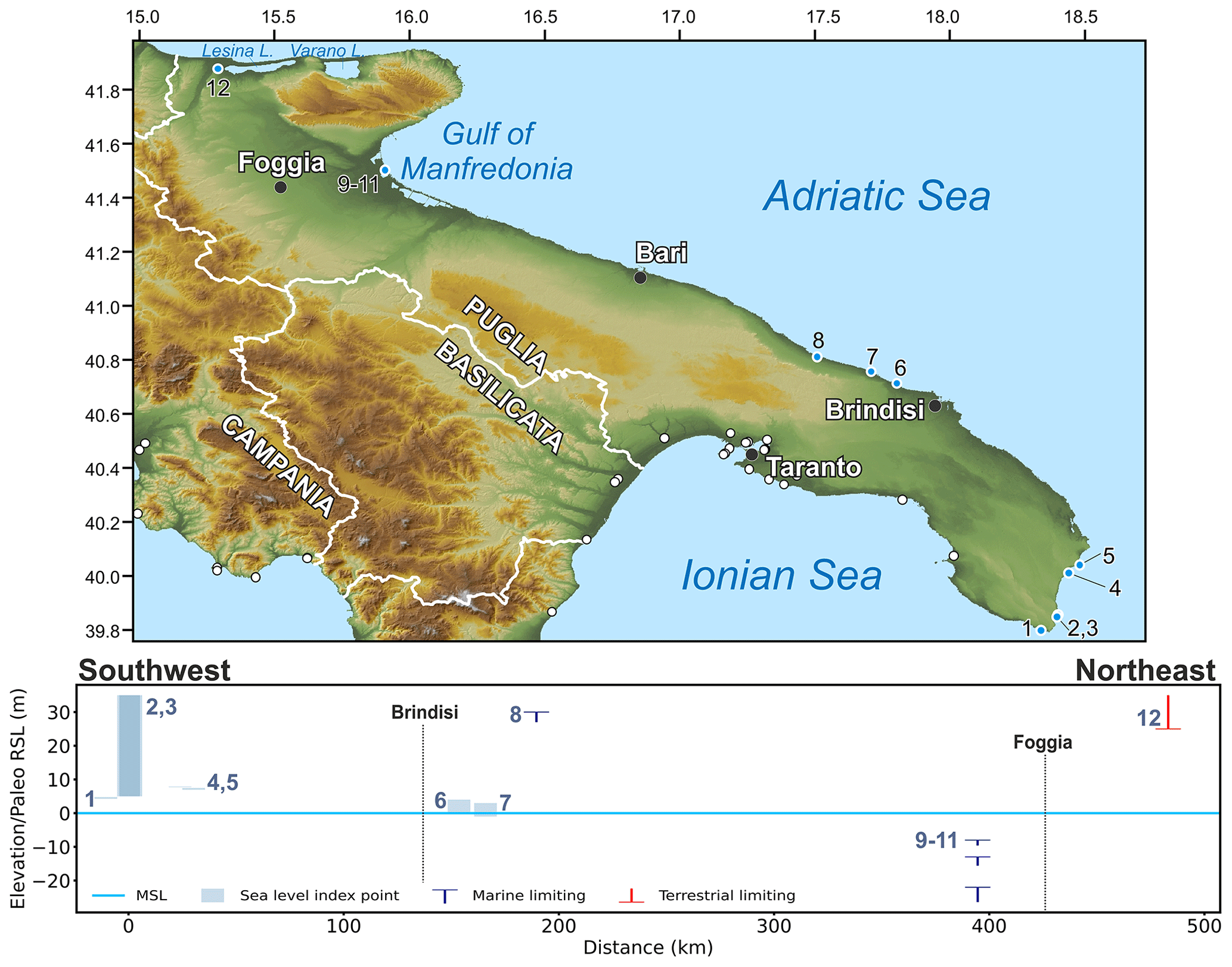
Figure 25MIS 5 sea-level data for the Adriatic side of Apulia (Italy). Upper panel: map of sites. Red dots are sites in the region of interest, and white dots are other sites within the western Mediterranean compilation. The topography has been obtained from the SRTM void-filled DEM (Farr et al., 2007, NASA dataset). Lower panel: distance/elevation graph, from southwest (left) to northeast (right). Sites list: 1: Grotta del Diavolo (RSL ID 3635); 2: Marina di Novaglie Site (RSL ID1324); 3: Marina di Novaglie Northern Site (RSL ID 1323); 4: Grotta Romanelli (RSL ID 1319); 5: Grotta delle Striare (RSL ID 1320); 6: Torre Mattarelle - Torre Guaceto (RSL ID 1321); 7: Torre Santa Sabina (RSL ID 1322); 8: Villanova-Monopoli (RSL ID 1318); 9: MM4 borehole Unit 13 (RSL ID 452); 10: MM4 borehole Unit 11 (RSL ID 453); 11: MM4 borehole Unit 10 (RSL ID 454); 12: Fortore River (RSL ID 1317).
7.3.8 Molise, Abruzzo, and Marche
The coastal sector from Molise to the southern boundary of the Romagna Plain (Fig. 26) extends for about 300 km and is generally characterized by narrow sandy beaches occurring at the base of the pre-Quaternary bedrock, which is commonly very close to the Holocene coastal morphostratigraphic units and often separated from them by a cliff of 5–15 m of elevation. In some limited sectors, the rocky coast faces the sea, such as near Vasto and between Fossacesia and Ortona, Numana and Ancona, Fano and Pesaro, and Pesaro and Gabicce.
The previous reviews and databases of sites with deposits of the Last Interglacial in the Marche region described in Ferranti et al. (2006) are derived from the work by Vannoli et al. (2004) in which some of the terraces occurring along the coast of the Marche region have been attributed to the Last Interglacial. However, the surveys carried out in the framework of the new geological map of Italy (Guerrara and Tramontana, 2011) and other recent investigations did not find any clear evidence of coastal deposits related to the Last Interglacial. On the contrary, the terraces consist of alluvial deposits dating to the Upper Pleistocene, but they are referred to as MIS 3 and 2. In light of this new information, the sites described in Ferranti et al. (2006) as the inner margin of terraces are considered in our compilation to be alluvial and not related to MIS 5e.
Figure 26MIS 5 sea-level data for Marche and Emilia-Romagna (Italy). Upper panel: map of sites. The topography has been obtained from the SRTM void-filled DEM (Farr et al., 2007, NASA dataset). Lower panel: distance/elevation graph, from southwest (left) to northeast (right). The lines depicting the innermost position of the coastline and of lagoon deposits of MIS 5e are derived from Campo et al. (2020). Sites list*: 1: Metauro River (RSL ID 1333); 2: Arzilla River (RSL ID 1332); 3: Conca River (RSL ID 1331); 4: 256-S3 Viserba Core S3 (RSL ID 1330); 5: 255-S4 Cesena Core S4 (RSL ID 1329); 6: 240-S8 Milano Marittima Core S8 (RSL ID 1308); 7: 240-S2 Villafranca Core S2 (RSL ID 1328); 8: 240-S13 Russi Core S13 (RSL ID 1327); 9: 223-S12 Ravenna Core S12 (RSL ID 1325); 10: 223-S17 Mandriole Core S17 (RSL ID 1326); 11: 222-S2 Voltana Core S2 (RSL ID 1310); 12: 204-S17 Argenta Core S-17 (RSL ID 1313); 13: 204-S4 Consandolo Core S4 (RSL ID 1312); 14: 204-S15 Marrara Core S-15 (RSL ID 1315); 15: Core 204-S16 Core S-16 (RSL ID 1314); 16: 205-S10 Comacchio Core S10 (RSL ID 1309); 17: Core F187_S1 Valle Giralda (RSL ID 1307). * Sites 1, 2, and 3 are rejected (see text for details) but inserted here for reference.
7.3.9 Emilia-Romagna
The alluvial plains facing the Italian side of the northern Adriatic, from Rimini to Monfalcone, are characterized by a subsiding tectonic setting mainly related to the crustal flexuring connected to the Apennines and the compaction of Quaternary sediments (cf. Carminati et al., 2003; Ferranti et al., 2006). Thus, the deposits of MIS 5e do not crop out in this area, but they are buried in the subsoil of the coastal plain at depths ranging from 35 to 120 m b.s.l. However, in Emilia-Romagna, the Geological Survey of the region collected a vast database of underground data (i.e., logs of stratigraphic boreholes, geotechnical tests, and water wells) in which a significant number of cores sampled the coastal deposits of MIS 5e (Fig. 26). The database has been mainly produced in the framework of the new geological map (CARG project) but has also been checked and tuned with specific stratigraphic and paleoenvironmental studies. In particular, Amorosi et al. (1999, 2004) defined the main architecture of the subsoil and characterized the depositional units for their sedimentological and palynological content.
Along the northwestern coast of the Adriatic, the sediments dated to the Last Interglacial correspond to a coastal wedge consisting of a transgressive–regressive cycle, which has an average maximum thickness of 15–20 m, overlapping the previous alluvial units, generally dating to MIS 6 (an example is reported in Fig. 27). The marine transgression expanded on the plain and induced the progressive shifting to lagoonal, beach, and marine environments. These deposits were later covered by the seaward progradation of deltaic systems, which can be generally related to the Po River system and the streams fed by the northern Apennines. The development of deltas probably occurred during the marine highstand of MIS 5e, around the peak of sea level. Thus, the beach facies recorded at the top of the regressive cycle are considered RSL index points with uncertainty between 7 and 10 m. A more significant role is played by the lagoonal and back-barrier deposits connected to the beach ridges, which have to be considered the most representative index point, with uncertainty between 0 and −2 m with respect to the coeval RSL. Differently, the facies of prodelta and marine platform deposited several meters below sea level and are considered only as marine-limiting points. The recognition of lagoonal and back-barrier facies is based on the micropaleontological content but also on the mollusk association consisting of Cerastoderma glaucum, Loripes sp., Hydrobia sp., Bittium sp., Abra sp., and Cerithium sp.
The marine transgression flooded large areas and, after the submersion, the action of waves developed an important ravinement surface that in many cases eroded almost completely the previous sediments connected to the sea-level rise (Fig. 26). Thus, the beach and marine deposits of MIS 5e are often directly in contact over the older alluvial plain and separated from them by a sharp ravinement surface. It is worth noting that this sedimentary nonconformity is rather easy to recognize in the cores in the northern Adriatic, representing a major tool for stratigraphic correlation. Worthy of note: it is not a synchronous surface, but it is time-transgressive (Massari et al., 2004; Amorosi et al., 2008a, b).
Mollusk faunal associations are not chronological markers per se but biostratigraphic markers if there are distinctive species present (e.g., Senegalese fauna with P. latus). However, the paleobotanical analyses carried out in a few selected cores recognized the pollen associations related to warm temperate climate characterized by broad-leaved trees which can be correlated with the general Eemian biostratigraphic unit also identified in other cores of northern Italy (Massari et al., 2004; Mullenders et al., 1996; Ravazzi et al., 2014) and, on a broader scale, in northern Europe (Peeters et al., 2019). In light of this information, in our database, the stratigraphic unit of the coastal deposits of MIS 5e has been named with the generic definition of “Adriatic Tyrrhenian (Eemian pollen unit)”. In Emilia-Romagna, reference cores for the pollen studies are the site 240-S13, near Russi (RSL ID 1327, no. 8 in Fig. 26), 240-S8, near Milano Marittima (RSL ID 1308, no. 6 in Fig. 26), 223-S17, at the southern boundary of Valli di Comacchio (RSL ID 1326, no. 10 in Fig. 26), and S1, south of Rimini (Amorosi et al., 1999; Campo et al., 2020).
Important geochronological constraints of these biostratigraphic units were supported by Ferranti et al. (2006) through the ESR dates of the beach deposits forming the top of the coastal wedge and collected in cores 204-S8 (117.0 m b.s.l., RSL ID 1308, no. 6 in Fig. 26), 222-S2 (112.5 m b.s.l., RSL ID 1310, no. 10 in Fig. 26), and 205-S10 (85.5 m b.s.l., RSL ID 1309, no. 16 in Fig. 26). They gave ages of 129±18, 154±26, and 124±20 ka, respectively, demonstrating that the unit formed during MIS 5e. At the moment these are the only published geochronological data in the northwestern Adriatic for the Last Interglacial, whereas some other OSL dates for younger stages of MIS 5 were produced recently (Amorosi et al., 2016; Campo et al., 2020).
The comparison between the elevation of the markers of the Last Interglacial with the maximum elevation reached by the sea during the highstand (i.e., some meters above sea level) clearly indicates that the index points recognized in the subsoil of Emilia-Romagna are not useful for investigating the paleo global mean sea level. On the contrary, these data were used by Ferranti et al. (2006) and Antonioli et al. (2009) to assess the average rate of tectonic subsidence that occurred since the deposition of the coastal wedge of MIS 5e.
The coastal plain south of the course of the modern Po River has been significantly involved in the current tectonic deformation related to crustal flexuring. In particular, the regional crustal subsidence increases with an southwesterly trend; moreover, the system of thrusts and folds affecting the most external and buried part of the Apennines produced important relative uplift and subsidence. Despite the vertical shifting suffered by the local sites, the limited chronological interval of MIS 5e and their rather easy recognition in the subsoil allowed Amorosi et al. (2009) to reconstruct a part of the coastline and the inner limit of the extent of the lagoons during the Last Interglacial in the northwestern Adriatic. Recently the paleogeographic setting at the MIS 5e highstand was strongly updated and improved for the area between Rimini and the Po Delta by Campo et al. (2020). The analysis of the database of Emilia-Romagna allows mapping of the environmental facies of the coastline existing at the marine highstand. We used these data, in combination with the other available markers detected in the subsoil of northern Italy, to depict the coastline from the Apennines to the Dinaric Alps, for a length of about 300 km (Figs. 26 and 28).
Figure 27(a) Stratigraphic section of the Venetian Friulian Plain, from the AZX Azzano core (RSL ID 1301, no. 8 in Fig. 28) via the PRA Belfiore core (RSL ID 793, no. 7 in Fig. 28) to the TdM Torre di Mosto core (RSL ID 1295, no. 6 in Fig. 28) (modified from Fontana et al., 2010). The trace of the section is indicated in Fig. 28. (b) Part of core PRA from 49 to 55 m of depth with typical sedimentary facies of a lagoonal environment. (c) Interval of core TdM from 64 to 71 m of depth with typical facies of the basal part of the MIS 5e marine transgression.
7.3.10 Veneto
In the Venetian Plain (Fig. 28) the number of available cores for investigating the MIS 5e marine highstand is limited, but, north of the modern course of the Po River, the coastal plain has not been deeply involved in significant tectonic deformations as it is part of the foreland basin of both the Alps and Apennines. Thus, despite the general regional subsidence affecting this area, the sediments of the Late Quaternary have not been locally deformed by thrusts and folds, and this setting preserved the original geometric relationships existing between the different sectors of the coastal wedge that formed during the Last Interglacial (Fig. 27).
In the Venice Lagoon, the deposits of MIS 5e are found underground at a depth spanning between 90 and 55 m b.s.l., and often the stratigraphic cores document a transgressive–regressive cycle. This trend can be recognized according to the landward migration of the marine facies at the base of the sequence, which overlaps the pre-existing alluvial plain and which was followed by the progradation of deltas and related lagoons. Near Valle Averto (core CARG 11, RSL ID 1304, no. 2 in Fig. 28), in the southern part of the Venice Lagoon, deltaic sediments are found over the alluvial deposits between 67 and 64 m b.s.l., covered by littoral facies at 64 and 62 m b.s.l. and after by lagoon deposits at 62–60.5 m b.s.l. (Donnici and Serandrei-Barbero, 2004). According to stratigraphic correlations, the vertical succession documents the marine transgression and the successive deltaic progradation with the formation of lagoon environments (Tosi et al., 2007b). A rather similar stratigraphic setting is also documented in the northern sector of the Venice Lagoon, near Portegrandi (core CARG 12, RSL ID 1302, no. 5 in Fig. 28), where paralic deposits are found between 70 and 55 m b.s.l. According to foraminifera analyses, from 70 to 65 m b.s.l. the depositional environments pass from neritic to lagoonal, whereas from 65 to 55 m b.s.l. the sediments are mainly sandy with few fossils, probably related to the delta front (Tosi et al., 2007a). This core can be used as an example of the rather low importance of this sequence for constraining the position of the sea level at the peak of the marine transgression of MIS 5e as the top portion could be used only as a marine-limiting point at 55 m b.s.l.
In Venice, the reference stratigraphy for the Pleistocene is the cores VE-1 and VE-1bis (RSL ID 1303, no. 4 in Fig. 28) that were drilled in 1971 in the Tronchetto, northwest of the city center (Kent et al., 2002; Massari et al., 2004, and references therein), and analyzed for sedimentological, pollen, and foraminiferal content. Core VE-01 arrived at a depth of 950 m and, as explained in Massari et al. (2004), the tie point between the two cores is represented by a characteristic Eemian pollen assemblage correlative with MIS 5e at 74.30 m b.s.l. in the VE-1 well and at 73.38 m b.s.l. in VE-1bis. The detailed investigations allowed us to recognize biostratigraphic units, mainly based on pollen assemblages for the Upper Pleistocene (Mullenders et al., 1996). According to Massari et al. (2004), in the core the base of the MIS 5e marine transgression is found at 78 m depth, and sediments belong to coastal facies up to 66 m depth and are covered by alluvial and lagoonal sediments. At 59.4–59 m depth in well VE-1bis a poorly developed lagoonal episode is recorded and was originally tentatively related to MIS 5c by Massari et al. (2004) but, in the light of some new unpublished cores in the Venice mainland, it is here considered to be the peak of the MIS 5e transgression. In the eastern sector of the Veneto region, several cores have been drilled in the framework of the CARG project and have allowed us to follow the deposits of MIS 5e from the alluvial plain to the marine facies (Fig. 27; Pini et al., 2009; Fontana et al., 2012). In particular, a stratigraphic section has been reconstructed from the mainland, at the boundary with Friuli Venezia Giulia (core AZX, RSL ID 1301, no. 8 in Fig. 28), to core PRA (RSL ID 793, no. 7 in Fig. 28), to the coast (core TdM, RSL ID 1295, no. 6 in Fig. 28, Fontana et al., 2010). In core AZX the MIS 5e deposits correspond to alluvial sediments characterized by warm temperate pollen from an elevation of 45.59 to 42.25 m b.s.l. (Pini et al., 2009), whereas 8 km south of this site, in core PRA, hyposaline internal lagoonal deposits are found at a depth between 49.5 and 55 m (i.e., 45.5 and 51 m b.s.l.). These latter ∼ 5 m rest on an alluvial plain with temperate cold pollens (Fontana et al., 2012) and were deposited at the peak of the marine highstand when the lagoon reached its most internal position. This stratigraphic interval of lagoonal sediments represents a significant index point for relative sea level during the peak of MIS 5e in the northwestern Adriatic as the base of lagoon sediments rests on an over-consolidated alluvial plain referred to as MIS 6 (Fontana et al., 2010).
The site of PRA is about 4 km upstream of the current isoline 0 m a.s.l., where brackish swamps were present up to the first part of the 20th century, when reclamation was carried out. According to this setting, the coastline of MIS 5e also reached a more landward position (Figs. 27 and 28), as in core TdM, where the coastal wedge sequence containing Eemian pollen association has its base at 70.5 m b.s.l. and the facies shift from the inner shelf to the delta front, and deltaic up to 50.4–41.7 m b.s.l. A rather similar sequence is also documented in cores LUG (RSL ID 1294, no. 10 in Fig. 28) and VV (RSL ID 1293, no. 11 in Fig. 28).
7.3.11 Friuli Venezia Giulia
Along the coastal plain, Veneto and Friuli Venezia Giulia are not separated by a physiographic boundary (Fig. 28), so it is not surprising that the stratigraphic setting described for the eastern sector of Veneto seems to be documented also in the easternmost region of northern Italy. A few kilometers north of the western boundary of the Grado-Marano Lagoon, Feruglio (1936) and Lipparini (1936) described for the first time in this sector the occurrence of a paralic unit of Pleistocene age at a depth around 40–50 m. In core PNC1 (RSL ID 1292, no. 13 in Fig. 28), near Marianis of Piancada, paralic deposits are found between 57.7 and −35.6 m b.s.l. (Fontana et al., 2010). The top portion of this interval is characterized by the presence of coastal and lagoon mollusks, and this layer was used as a marine-limiting point by Antonioli et al. (2009). Core PNC1 was drilled in the framework of the VECTOR project (Busetti et al., 2010), as borehole BLG1 (RSL ID 1290, no. 14 in Fig. 28), near Aquileia, which is a reference for the eastern portion of the Grado-Marano Lagoon. In this core coastal deposits are found from 55.4 to 39.1 m of depth, documenting the transgression from marine facies to lagoon deposits. This unit is interpreted as evidence of the Last Interglacial based on stratigraphic correlation. Several samples of shells from this unit in core BLG1 have been dated with ESR, but the obtained results are characterized by large uncertainties and allow us only to generically attribute the samples to MIS 5.
East of Monfalcone the coast is rocky and characterized by a karst environment, where deposits and landforms related to the Upper Pleistocene are almost completely lacking. Some evidence of Last Interglacial coastal features has been suggested in this area of the Gulf of Trieste (Albrecht and Mosetti, 1987; Antonioli et al., 2009), but in the light of this review of data, they seem unreliable. Recently, on the coast near Trieste, the geophysical investigations highlighted the occurrence of a buried flat surface cut into the Flysch bedrock and often related to a basin-ward coastal wedge. The surface has been interpreted as a marine terrace produced during MIS 5e and, according to different wave velocity models, the top of the terrace is assessed at depths ranging between 70 and 50 m b.s.l. (Romeo, 2009) and between 35 and 40 m b.s.l. (Zampa, 2014). As no geochronological constraints are available, eventually a generic MIS 5 age can possibly be assessed for the formation of this landform and the related sedimentary wedge. Moreover, it is worth noting that even in the shallower interpretation the elevation of these proxies for past marine levels are rather comparable to the position of the index points of MIS 5e documented in the Friulian Plain, but that area should have been affected by subsidence compared to the coast of Trieste in the last 125 ka.
Figure 28MIS 5 sea-level data for Veneto and Friuli Venezia Giulia (Italy). Upper panel: map of sites. The topography has been obtained from the SRTM void-filled DEM (Farr et al., 2007, NASA dataset). Lower panel: distance/elevation graph, from southwest (left) to northeast (right). The lines depicting the innermost position of the coastline and of the lagoon deposits of MIS 5e are modified after Antonioli et al. (2009). Sites list: 1: Ca' Borille Core (RSL ID 1306); 2: Valle Averto Core CARG 11 (RSL ID 1304); 3: Malamocco Core (RSL ID 1305); 4: VE-1 Core Venezia1 (RSL ID 1303); 5: Portegrandi Core CARG12 (RSL ID 1302); 6: TdM Torre di Mosto Core (RSL ID 1295); 7: PRA Belfiore Core (RSL ID 793); 8: AZX Azzano Core (RSL ID 1301); 9: CNC4 Concordia Sagittaria Core (RSL ID 1289); 10: LUG Lugugnana Core (RSL ID 1294); 11: VV Valle Vecchia Core (RSL ID 1293); 12: Piancada Piancada town (RSL ID 1291); 13: PNC1 Piancada Core (RSL ID 1292); 14: BLG1, Beligna Core (RSL ID 1290). The red line connecting points 6–8 represents the cross section of Fig. 27.
7.3.12 Istria, Kvarner Gulf, and Dalmatia
Along the eastern side of the Adriatic Sea, the coast presents rather homogeneous characteristics from the Gulf of Trieste, in Italy, to the northern boundary of Albania. In particular, this stretch of coast, which includes the coasts of Slovenia, Croatia, Bosnia–Herzegovina, and Montenegro, is influenced by the tectonic structures of the Dinaric Alps, which have a NW–SE direction and largely consist of carbonatic bedrock (Pikelj and Juračić, 2013).
At the moment, along this sector of the coast with a length of over 600 km and characterized by karst landscape, no clear evidence of RSL indicators of the MIS 5e transgression is documented.
However, some indirect information can be inferred by the comparison with the index points referred to as MIS 5a, which have been recently documented in the Kvarner Gulf through isotopic analyses of speleothems (cf. Dumitru et al., 2020, for a synthesis of the whole Mediterranean coast). In the submerged cave of U Vode Pit in Krk, Surić et al. (2009) studied two stalagmites, K-14 and K-18, collected at 14.5 and 18.8 m b.s.l., respectively. These speleothems have been dated through U Th and investigated for their chemical composition, leading Surić et al. (2009) to infer that they were submerged by marine waters during highstands of MIS 5a and, thus, in case of stable conditions, sea level was higher than 14 m b.s.l. The authors also suggested the possible occurrence of a general regional tectonic uplifting in the area with long-term rates of 0.15–0.25 mm a−1.
According to the reconstructions of the global sea-level curves, it is likely that the RSL at the peak of MIS 5e was over 20 m higher than the level reached for MIS 5a. Thus, these points can be eventually interpreted as marine-limiting points also for MIS 5e but with a larger uncertainty.
This setting strongly contrasts with the situation reconstructed along the western coast of the northern Adriatic, where subsidence was a leading process during the Quaternary. However, this asymmetric evolution of the opposite sides is not surprising, as along the Dalmatian coast the long-term geological data suggest general stability.
Another interesting site is located east of Lošinj, where Brunović et al. (2020) investigated the deposits recorded in the so-called Lošinj Channel, an isolation basin that during sea-level fall was separated from the rest of the Adriatic because of a sill at 50 m b.s.l. In the area, the analysis of a core from a water depth of 64–62 m documented the occurrence of marine deposits, and these have been tentatively dated to MIS 5a based on correlation with the data produced by Surić et al. (2009). Also in this case the area is considered a stable sector because the Late Glacial and Holocene RSL index points are in agreement with the predicted sea-level curve, suggesting a limited vertical displacement.
In the northern sector of Albania, near the Bay of Drini, Marku and Gjani (2018) suggested the existence of a tidal notch at an elevation between 30 and 40 m a.s.l. referred to as MIS 5e. However, as the morphological evidence supporting this interpretation is not very consistent and the age estimation is only hypothesized, this site is not considered in WALIS as a proxy for the RSL of the Last Interglacial.
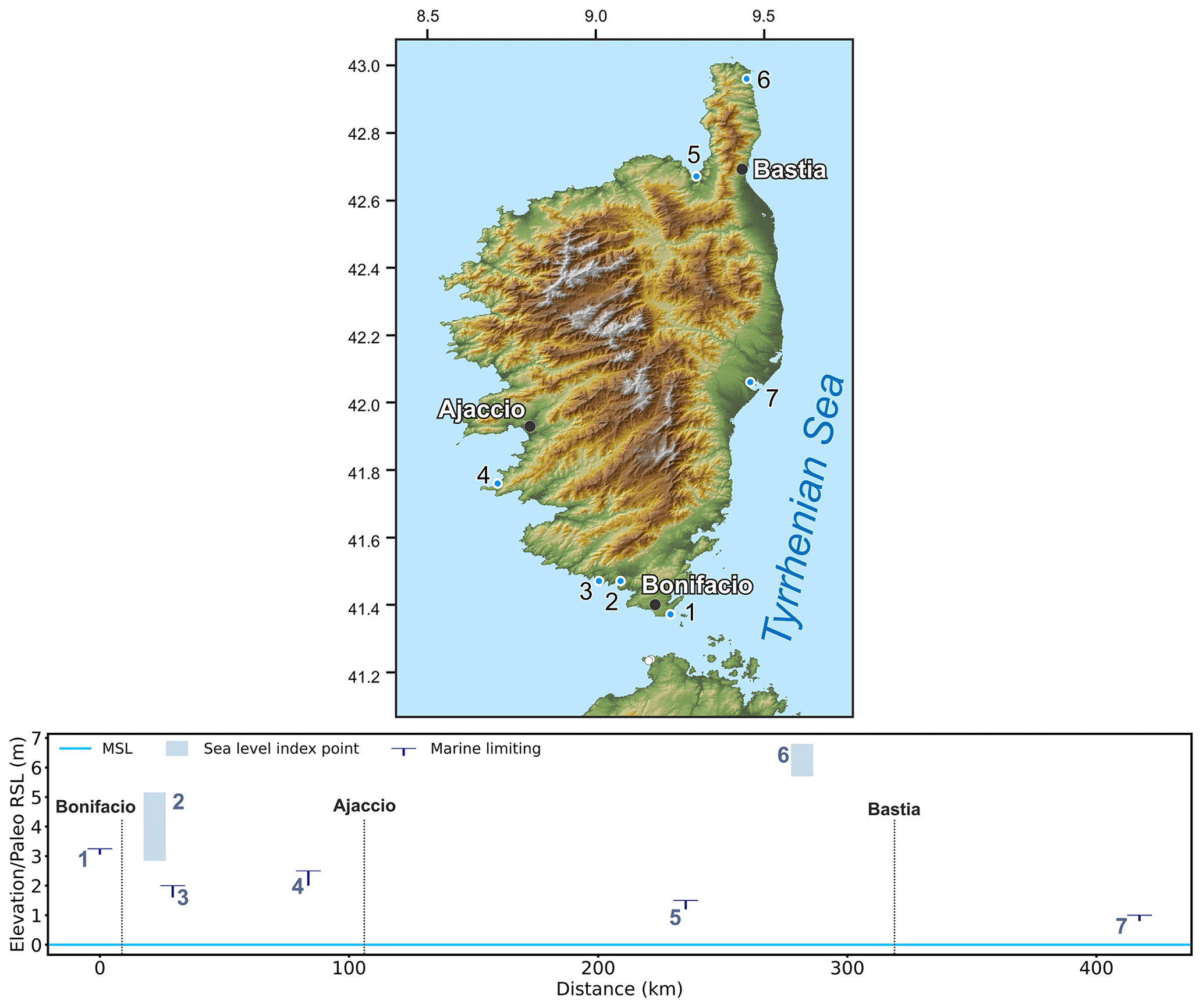
Figure 29MIS 5 sea-level data for Corsica (France). Upper panel: map of sites. The topography has been obtained from the SRTM void-filled DEM (Farr et al., 2007, NASA dataset). Lower panel: distance/elevation graph, clockwise around the island starting from the southernmost point. Sites list: 1: Piantarella (RSL ID 277); 2: Figari (RSL ID 321); 3: Arbitru (RSL ID 323); 4: Ajaccio Gulf Capo Moru (RSL ID 303); 5: St Florent (RSL ID 299); 6: Macinaggio Tamarone (RSL ID 931); 7: Urbino (RSL ID 322).
7.4 Corsica, Sardinia, and Sicily
7.4.1 Corsica
Corsica (Corse) is the third-largest western Mediterranean island and hosts a great number of Quaternary marine deposits (Fig. 29) which span the whole perimeter of the island (Conchon, 1985, 1999). Along the northern coasts of the island (Macinaccio and St. Florent) the presence of an upper limit of Lithophaga boreholes (RSL ID 931, no. 6 in Fig. 29) and shallow coastal deposits (RSL ID 299, no. 5 in Figs. 29, 30) dominated by Arca noe and Patella ferruginea (Ottmann, 1954) seems to indicate that the maximal transgression during the Last Interglacial did not exceed 6.25 m a.s.l. The single chronological constraint available in this area is represented by a Glycimeris shell dated with AAR (AAR ID 93, Hearty et al., 1986a) which yielded an MIS 5e age.
Along the central to southern coasts of the island, Conchon (1999) reports several shallow marine or lagoonal deposits that were found at elevations ranging from 1 to 3 m a.s.l. Among these, the most robust indicator is represented by some oysters found in lagoonal facies (RSL ID 321, no. 2 in Fig. 29) near Figari, which allowed reconstruction of a paleo sea level at 4±1.1 m a.s.l. This is consistent with the elevation of some marine encrustations which constrain the paleo sea level above 3.25 m a.s.l. near Bonifacio (RSL ID 277, no. 1 in Fig. 29, Nesteroff, 1984). We assumed a general MIS 5 age of this paleo sea-level stand even if a robust chronological attribution is currently not available. The shells found in all these deposits were only dated with radiocarbon techniques yielding infinite (19 to 40 ka) ages (Delibrias et al., 1972; Nesteroff, 1984).
Figure 30Littoral deposits in St Florent, Corsica (RSL ID 299, no. 5 in Fig. 29). Photo by Matteo Vacchi.
7.4.2 Sardinia
Sardinia (Sardegna) is a key Mediterranean region for the study of Last Interglacial landforms and deposits. It is among the most tectonically stable areas in the Mediterranean and hosts a large abundance of Late Pleistocene coastal deposits as well as well-preserved erosional evidence of paleo sea-level highstands (Andreucci et al., 2010; Ferranti et al., 2006; Ulzega and Hearty, 1986, Fig. 31). The most outstanding evidence of a paleo sea-level stand is the presence of a fossil tidal notch that can be observed at different elevations, both on the eastern and western coasts of the island (Antonioli et al., 2018). Along the eastern coast, the fossil notch was observed at several sites, with some slight variability in its elevation. In Pedralonga (RSL ID 432, no. 1 in Fig. 31) and Capo Monte Santu (RSL ID 435, no. 2 in Fig. 31), the notch has average elevations between 7.4 and 7.6 a.s.l., while it increases to 9.5 m a.s.l. in the central part of the Gulf of Orosei (RSL ID 434, no. 3 in Fig. 31). In the northern portion of the eastern coast, the notch was observed both in Capo Figari (RSL ID 430, no. 6 in Fig. 31) and in Tavolara Island (RSL ID 431, no. 5 in Fig. 31) at average elevations ranging from 4.7±0.4 to 6.7±0.5 m a.s.l. In Tavolara, Glycimeris shells found in a marine deposit (correlated with the notch) yielded an MIS 5e age (AAR ID 92, Belluomini et al., 1986). This date is the only chronological constraint available for the whole eastern coast of Sardinia.
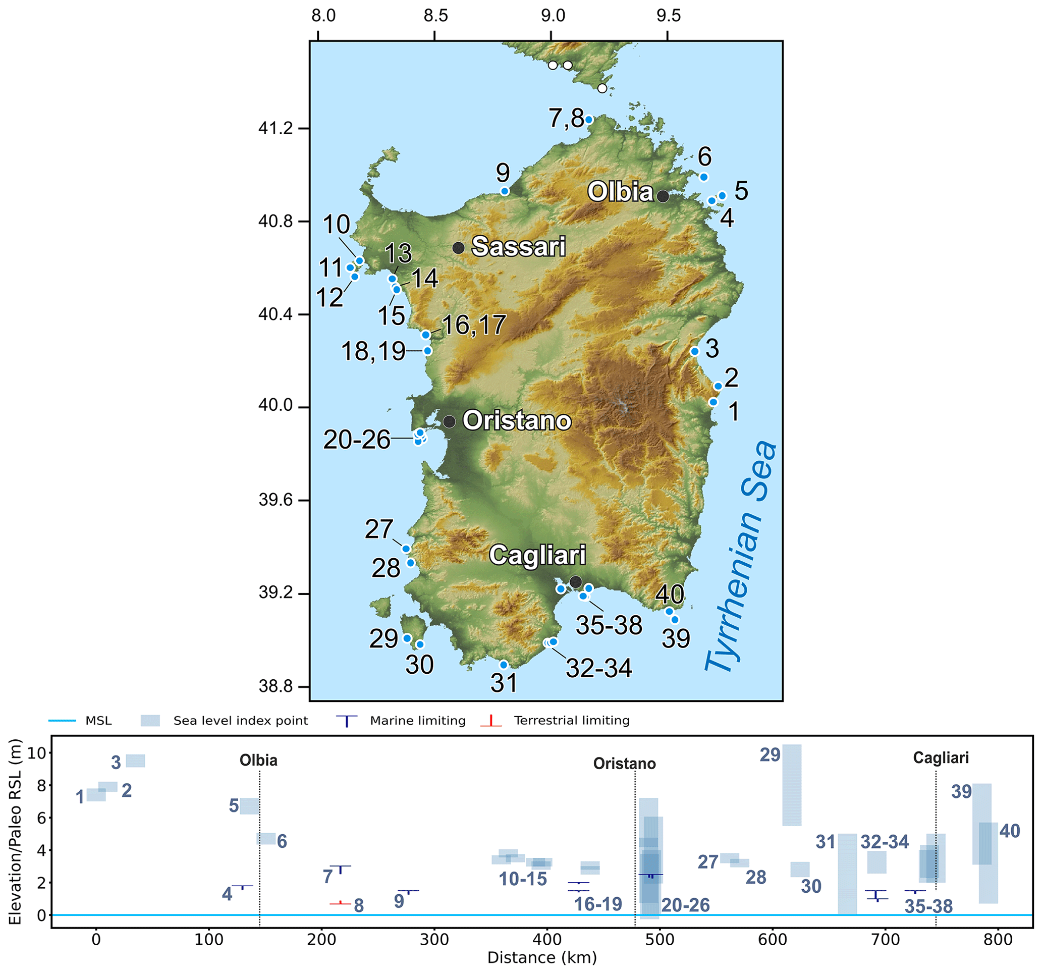
Figure 31MIS 5 sea-level data for Sardinia (Italy). Upper panel: map of sites. The topography has been obtained from the SRTM void-filled DEM (Farr et al., 2007, NASA dataset). Lower panel: distance/elevation graph, counterclockwise around the island. Sites list: 1: Pedralonga (RSL ID 432); 2: Capo Monte Santu (RSL ID 435); 3: Orosei Nord (RSL ID 434); 4: Tavolara Punta la mandria (RSL ID 292); 5: Tavolara (RSL ID 431); 6: Capo Figari (RSL ID 430); 7: Capo Testa, Santa Reparata TLI (RSL ID 289); 8: Capo Testa, Santa Reparata MLI (RSL ID 290); 9: Badesi Mare San Pietro a Mare (RSL ID 300); 10: Cala Viola (RSL ID 388); 11: Capo Caccia 1 (RSL ID 382); 12: Capo Caccia 2 (RSL ID 383); 13: El tró (RSL ID 234); 14: Punta Padre Bellu (RSL ID 235); 15: Baurantinu (RSL ID 236); 16: Bosa Sect.1 (RSL ID 241); 17: Bosa Sect 2 (RSL ID 243); 18: Bosa Sect 3 (RSL ID 244); 19: Porto Alabe (RSL ID 238); 20: San Giovanni del Sinis (RSL ID 262); 21: San Giovanni del Sinis (RSL ID 271); 22: San Giovanni del Sinis (RSL ID 272); 23: San Giovanni del Sinis (RSL ID 265); 24: Faro Capo San Marco (RSL ID 266); 25: Capo San Marco (RSL ID 261); 26: San Giovanni del Sinis (RSL ID 263); 27: Buggerru (RSL ID 437); 28: Masua (RSL ID 436); 29: Sant'Antioco Cala Sapone (RSL ID 296); 30: Sant'Antioco (RSL ID 433); 31: Capo Malfatano (RSL ID 295); 32: Nora (RSL ID 1336); 33: Nora Is Fradis (RSL ID 1337); 34: Nora-Is Fradis (RSL ID 279); 35: Sa Illetta (RSL ID 278); 36: Cagliari Marina Piccola (RSL ID 1338); 37: Cagliari Cala Mosca (RSL ID 132); 38: Is Arenas (RSL ID 276); 39: Capo Carbonara Villasimius (RSL ID 293); 40: Capo Carbonara Isola dei cavoli-Cala Ponente (RSL ID 294).
Along the northern coast, Ozer et al. (1980) reported P. latus in beach deposits found at 2.5 m a.s.l. in Capo Testa. This level lies above a subtidal facies which was dated with AAR (AAR ID 90) yielding an MIS 5e age (Belluomini and Delitala, 1988; Kindler et al., 1997). The lack of clear intertidal deposits at this location did not allow for a precise definition of the sea-level evolution during the whole Last Interglacial period. The available data only indicate that the paleo sea level was above 1.5 m a.s.l. during MIS 5e and at or slightly below 1 m during MIS 5c (AAR ID 91). This trend is further confirmed by an additional date (AAR ID 94) which constrains the paleo sea level above 1.5 m a.s.l. during MIS 5e (Belluomini and Delitala, 1988).
The western coast of Sardinia hosts a large number of MIS 5 littoral deposits which were already identified at the beginning of the last century (Issel, 1914) and widely investigated in the last 40 years (Ulzega and Hearty, 1986; Sechi et al., 2020; Carboni et al., 2014). In Capo Caccia, Alghero, and Bosa, the concomitant presence of well-preserved fossil notches (RSL IDs 382 and 383, nos. 11 and 12 in Fig. 31, Antonioli et al., 2018), beach deposits (RSL ID 388, no. 10 in Fig. 31, Casini et al., 2020), and fossil bioconstructions (RSL IDs 234 and 238, nos. 13–19 in Fig. 31, Sechi et al., 2020) robustly placed the MIS 5e shoreline between 3 and 4 m a.s.l. The quality of the chronological constraint for this area was significantly increased by a series of recent OSL dates performed near Capo Caccia (LUM ID 120; Casini et al., 2020), in Alghero (LUM IDs 61, 64, and 68, Sechi et al., 2020; Andreucci et al., 2010), and in Bosa (LUM ID 75, Sechi et al., 2020).
More southwards, impressive outcrops of Upper Pleistocene littoral deposits occur in the San Giovanni del Sinis (Fig. 32) area (Carboni et al., 2014; Andreucci et al., 2009; Lecca and Carboni, 2007). These are represented by a complete sequence which includes shoreface, foreshore, lagoonal, and dunal deposits. The age of these deposits was investigated both with OSL (Andreucci et al., 2009) and with U Th on corals (Carboni et al., 2014; D'Orefice et al., 2012). Both techniques (LUM ID 81 and U-series IDs 550–551 and 555–557) confirmed the MIS 5 ages for most of these littoral deposits, as already suggested by the presence of Senegalese fauna (Carboni and Lecca, 2008). A further AAR date (AAR ID 203) yielded MIS 5c age (Ulzega and Hearty, 1986), while a basal unit found in the northernmost sector of San Giovanni del Sinis yielded MIS 7 age (LUM ID 81, Andreucci et al., 2009). The coupled analysis of all these data indicates that RSL was placed between 2 and 5 m a.s.l. during MIS 5e (RSL IDs 262, 263, 265, 266, and 271, nos. 20, 26, 23, 24, and 22 in Fig. 31). The analysis stratigraphic facies of San Giovanni del Sinis seem also to indicate that the maximal sea-level highstand is preceded by millennial sea-level oscillations within MIS 5e, which were recorded by the different littoral facies (Carboni et al., 2014).
In the southwestern portion of the island, the occurrence of a well-preserved tidal notch at ∼ 2.8 to 3.5 m a.s.l. was observed from Buggerru to Sant'Antioco Island (RSL IDs 433, 436, and 437, nos. 30, 28, and 27 in Fig. 31, Antonioli et al., 2018). An MIS 5e age was attributed to this paleo shoreline thanks to the correlation with some littoral deposits found at similar elevations. They are rich in Senegalese fauna (including P. latus) and were dated with AAR techniques (AAR ID 127, Ulzega and Ozer, 1980; Ulzega and Hearty, 1986).
Along the southern coast of the island, beach deposits rich in Senegalese fauna (including P. latus) were found in some littoral deposits near the archeological site of Nora (Ulzega and Hearty, 1986; Kindler et al., 1997). Two AAR dates (AAR IDs 204–205) yielded MIS 5e age even if some contrasting interpretations of the age of these deposits are present in the literature (Kindler et al., 1997). The facies analysis of this outcrop allowed reconstruction of a paleo shoreline placed at ∼ 3.3 m during MIS 5e (RSL ID 1337, no. 33 in Fig. 31). This elevation is in agreement with the paleo shoreline reconstructed in the Cagliari area (RSL IDs 132, 276, and 1338, nos. 37, 38, and 36 in Fig. 31), whose MIS 5e age was constrained by U-series and AAR dating (Hearty et al., 1986a; Ulzega and Hearty, 1986).
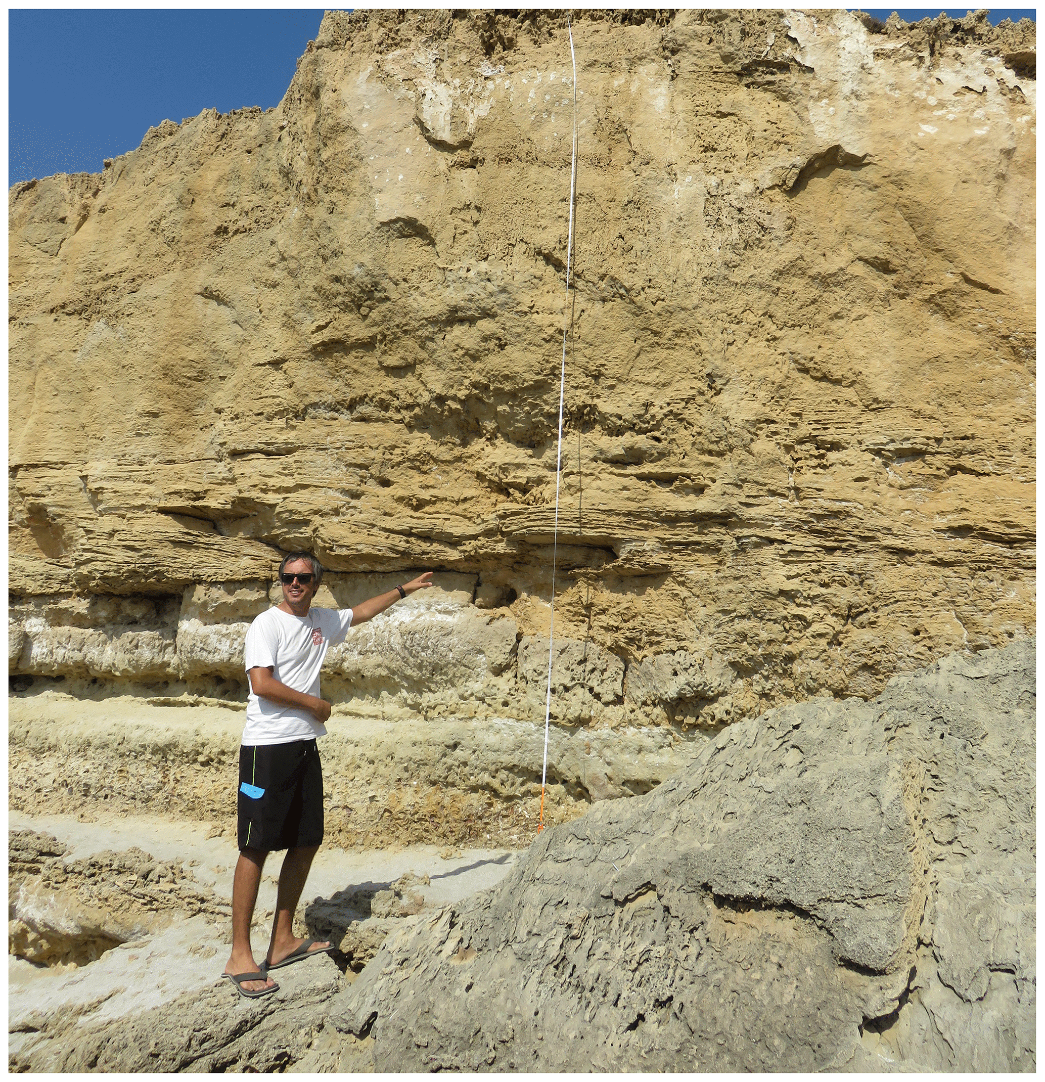
Figure 32Last Interglacial outcrop at San Giovanni del Sinis (RSL ID 262, no. 20 in Fig. 31). In the photo, Alessio Rovere is pointing to the contact between subtidal (below) and intertidal (above) beds. Photo by Elisa Casella.
7.4.3 Sicily
Antonioli et al. (2006) reviewed the elevation of RSL indicators of the Last Interglacial around the coasts of Sicily (Sicilia) and the Egadi, Lampedusa, Ustica, and Eolian islands, updating former compilations, most notably the one by Bordoni and Valensise (1999). Within the island, Antonioli et al. (2006) distinguished four distinct tectonic sectors that are described separately hereafter.
Sector 1 (Fig. 33) spans between the coastal towns of Trapani and Cefalù and includes the Egadi Islands to the west. Along the Egadi Island coasts, P. latus specimens and Senegalese fauna within fossil beaches have been found on the island of Levanzo, between 2 and 6 m a.s.l. (RSL IDs 852 to 854, nos. 16, 17, and 15 in Fig. 33) by Malatesta (1957) and up to 12 m a.s.l. in Favignana (RSL ID 855, no. 3 in Fig. 33) by Abate et al. (1992, 1996). Antonioli et al. (2002) measured the elevation of the tidal notches on the island of Marettimo at ∼ 5–8 m a.s.l. (RSL IDs 833 to 843, nos. 4 to 14 in Fig. 33). On the mainland, the areas surrounding the towns of Trapani and Marsala are characterized by marine deposits bearing P. latus at elevations of 2 to 5 m a.s.l. (Ruggieri and Buccheri, 1968; Ruggieri and Unti, 1988, RSL IDs 919 and 920, nos. 2 and 18, respectively, in Fig. 33). A similar elevation range, 2–3 m a.s.l., with the presence of sediments bearing P. latus has also been evaluated between Marsala and the Mazzara del Vallo area (Ruggieri et al., 1975). These deposits lie on a terrace that has its inner edge at 34 m a.s.l. (RSL ID 899, no. 1 in Fig. 33).
Northwest of Trapani, Mauz et al. (1997) surveyed Last Interglacial sea-level proxies in the Gulf of Castellammare and Capo San Vito (RSL IDs 822 and 823, nos. 24 and 23, RSL IDs 826 to 829, nos. 28 to 25, RSL ID 830, no. 21, RSL IDs 844 and 845, nos. 22 and 20 in Fig. 33), integrating thermoluminescence dating and paleontological investigations. These authors recognized evidence of MIS 5e in the 5–18 m elevation range. Moreover, in Capo San Vito, Abate et al. (1991) show the presence of Senegalese fauna, and Antonioli et al. (2002) dated with U-series speleothems to constrain the age of a tidal notch. These studies have confirmed the presence of a marine terrace up to 14 m a.s.l. (RSL ID 923, no. 23 in Fig. 33) and a tidal notch up to 8 m a.s.l. (RSL ID 922, no. 24 in Fig. 33), both correlated with MIS 5e (Abate et al., 1996, 1993). Fabiani (1941), Gignoux (1913), and Antonioli et al. (2006) reported specimens of P. latus between 2 and 10 m a.s.l. in Palermo (RSL IDs 896 and 832, nos. 32 and 31 in Fig. 33) and nearby areas (Capo Gallo, RSL ID 897, no. 30 in Fig. 33), while AAR dating on Glycimeris allowed Hearty (1986) to reject the correlation of fossil marine deposits a few tens of meters above sea level with MIS 5e previously made by Ruggieri and Buccheri (1968).
Towards the easternmost point of Sector 1, Antonioli et al. (2006) constrained Glycimeris-bearing marine deposits to MIS 5a and 5c between ∼ 7 and ∼ 10 m a.s.l. in the area of Cefalù (RSL ID 862, no. 34 in Fig. 33) with AAR. This constraint allowed us to correlate with MIS 5e a tidal notch in the Cefalù promontory and La Kalura promontory (RSL ID 863, no. 35 in Fig. 33) at 29 and 30 m a.s.l., respectively. The elevation of the tidal notch decreases considerably eastward; in fact, in Capo Zafferano (RSL ID 831, no. 33 in Fig. 33) it has been found at 7 m a.s.l. and constrained by AAR dating on Arca shells (Antonioli et al., 1994b).
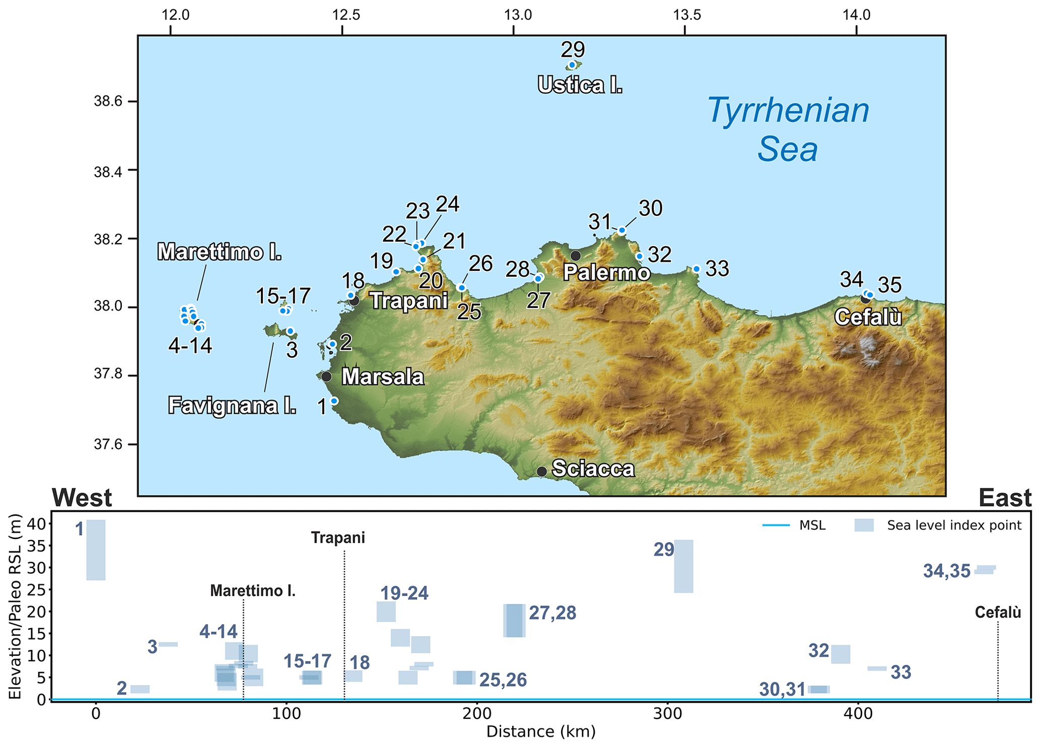
Figure 33MIS 5 sea-level data for Sicily, Sector 1 (Italy). Upper panel: map of sites. Red dots are sites in the region of interest, and white dots are other sites within the western Mediterranean compilation. The topography has been obtained from the SRTM void-filled DEM (Farr et al., 2007, NASA dataset). Lower panel: distance/elevation graph, from west (left) to east (right). Sites list: 1: Marsala-Mazzaro del Vallo Torre Scibiliana (RSL ID 899); 2: Trapani Birgi (RSL ID 919); 3: Favignana Egadi archipelago (RSL ID 855); 4: Facciazzo Marettimo Island (RSL ID 841); 5: Cala Marino Marettimo Island (RSL ID 836); 6: Cala Marino (II) Marettimo Island (RSL ID 840); 7: Cala Conca Marettimo Island (RSL ID 842); 8: Cala Nera Marettimo Island (RSL ID 843); 9: P. Pegna Marettimo Island (RSL ID 837); 10: P.ta Due Frati Marettimo Island (RSL ID 833); 11: Scalo Maestro Marettimo Island (RSL ID 834); 12: Tuono Marettimo Island (RSL ID 838); 13: Sco. Camello Marettimo Island (RSL ID 835); 14: Passo del Bue Marettimo Island (RSL ID 839); 15: Pietre Varate Levanzo Island (Egadi archipelago) (RSL ID 854); 16: Cala Dogana Levanzo Island (Egadi archipelago) (RSL ID 852); 17: Cala Fredda Levanzo Island (Egadi archipelago) (RSL ID 853); 18: Trapani- Tonnara S. Giuliano (RSL ID 920); 19: Monte Cofano Trapani (RSL ID 894); 20: Castelluzzo San Vito lo Capo (RSL ID 845); 21: Macari (RSL ID 830); 22: Cala Mancino San Vito lo Capo (RSL ID 844); 23: San Vito lo Capo W side (RSL ID 923); 24: San Vito lo Capo NE side (RSL ID 922); 25: Cala Rossa (RSL ID 828); 26: Cala Bianca (RSL ID 829); 27: Torre San Cataldo (RSL ID 827); 28: Nocella (RSL ID 826); 29: Ustica (RSL ID 916); 30: Palermo Capo Gallo (RSL ID 897); 31: Capo Gallo (RSL ID 832); 32: Palermo (RSL ID 896); 33: Capo Zafferano (RSL ID 831); 34: Cefalù (RSL ID 862); 35: Cefalù (II) La Kalura (RSL ID 863).
In southwestern Sicily (Sector 2), Antonioli et al. (2006) reported that in the area spanning from Cape Granitola to Cape Passero, no evidence of MIS 5 is present. Probably, the bedrock lithologies have played an important role in terms of preservation of RSL indicators along the coast of Sector 2, or negative vertical movements could have downthrown MIS 5 indicators.
Sector 3 extends between the towns of Pachino (to the south) and Monte Tauro (to the north). P. latus specimens embedded in a beach deposit were reported by Malatesta (1985) at 15 m a.s.l. in the Pachino area (RSL ID 900). By geomorphological correlation with this terrace, beach deposits assigned to MIS 5 have been reported also at the S. Lorenzo and Avola sites, at 4 and 5 m a.s.l. In Augusta (Monte Tauro), Di Grande and Scamarda (1973) and Di Grande and Neri (1988) report the presence of P. latus correlated with a marine terrace inner edge at 15 m a.s.l. (RSL ID 901). Meschis et al. (2020) mapped the marine terraces along the Syracuse coast by a synchronous correlation method using as age constraints U-series dating on speleothems (Dutton et al., 2009a), which provide a terrestrial-limiting point for the end of MIS 5a (Plemmiro Cave, RSL ID 3577). The MIS 5e terrace, according to the reconstruction by Meschis et al. (2020), spans from ∼ 30 up to ∼ 70 m a.s.l. This estimate, which was based on ESR dating on mammal teeth (Rhodes, 1996), is at odds with the interpretation of Bianca et al. (1999), according to which the MIS 5e marine terrace decreases from 10 m in Augusta to 75 m in Avola. In particular, the MIS 5e terrace of Meschis et al. (2020) corresponds to the MIS 3c terrace of Bianca et al. (1999). However, the dating of Rhodes (1996) used by Bianca et al. (1999) has not been included in the database, as it was discarded by Antonioli et al. (2006) as not robust.
The last sector covers the northeastern part of Sicily (Sector 4, Fig. 34) and extends between the city of Catania and the town of Acquedolci, near Messina. MIS 5e sea-level proxies along the Etna coast were chronologically constrained indirectly by K / Ar dating on lava flows of MIS 7 age (Gillot et al., 1994), which were successively incised by a marine terrace (Monaco et al., 2000). The inner margin of this terrace has been reported at a maximum of 175 m a.s.l. in Aci Trezza (RSL IDs 846 to 848, nos. 4 to 6 in Fig. 34) and slowly decrease in elevation towards the south, reaching a maximum of 165 m a.s.l. in Catania (RSL IDs 849 to 851, nos. 1 to 3 in Fig. 34).
Catalano and Guidi (2003) mapped a staircase sequence of marine terraces, including the Last Interglacial one, for the northeastern sector of Sicily, from the Strait of Messina to the Taormina area, but no dating or Senegalese fauna reports for these terraces are available. The first MIS 5 age constraint for the Taormina sector is an ESR dating on littoral fossils Patella and Venerupis shells, provided by Antonioli et al. (2006) at 115 m a.s.l. (RSL ID 903, no. 8 in Fig. 34), whereas Bonfiglio (1981) reported a tidal notch with serpulids in a cave at 130 m a.s.l. (RSL ID 3626, no. 7 in Fig. 34).
At the northern tip of Sector 4 lies Capo Peloro, where Bonfiglio and Violanti (1983) recognized specimens of P. latus at 86 m a.s.l. These were correlated with MIS 5e with AAR by Hearty et al. (1986b). The marine terrace inner edge corresponding to MIS 5e was placed at 110 m a.s.l. (RSL ID 902, no. 2 in Fig. 34) by Antonioli et al. (2004) and at 125 m a.s.l. by Catalano and Guidi (2003). Since the elevation proposed by Catalano et al. (2003) is based only on a geomorphological correlation with a marine terrace at Capo Rasocolmo at 125 m a.s.l., and in the absence of more dating, such a point has not been included in the database.
Hearty and Dai Pra (1986) dated Arca and Glycimeris shells related to the MIS 5e deposits in the Capo Milazzo (Cape Milazzo) area, at ∼ 90 m a.s.l. (RSL ID 921, no. 10 in Fig. 34). Worth noting is that in Capo Milazzo (Faibridge, 1973), the stratotype sites (Depéret, 1918) for the Middle Pleistocene (old definition of Quaternary, Gibbard and Head, 2010), Milazziano time, according to the outdated terrace system of Fairbridge (1973), were located at ∼ 60 m a.s.l.
At the northern edge of Sector 4, Giunta et al. (2012) mapped five orders of marine terraces, two of which were dated by OSL on unconsolidated marine sands. These ages allowed correlation of the terrace at 50 m a.s.l. with MIS 5e (RSL ID 924, no. 17 in Fig. 34). Such correlation is supported by a synchronous correlation method (Meschis et al., 2018).
In front of the northern coast of Sector 4, the Aeolian Islands also underwent long-term uplift. The inner edge of marine terraces related to MIS 5e spans from 40 m a.s.l. in Filicudi (RSL ID 914, no. 16 in Fig. 34, Lucchi et al., 2004a, b), 45 m a.s.l. on Lipari (RSL IDs 909 to 911, nos. 13 to 15 in Fig. 34), to 115 m a.s.l. in Panarea (RSL IDs 917 and 918, nos. 11 and 12 in Fig. 34, Radtke, 1986).

Figure 34MIS5 sea-level data for Sicily, Sector 4 (Italy). Upper panel: map of sites. Red dots are sites in the region of interest, and white dots are other sites within the western Mediterranean compilation. The topography has been obtained from the SRTM void-filled DEM (Farr et al., 2007, NASA dataset). Lower panel: distance/elevation graph, counterclockwise from Catania to Cefaù. Sites list: 1: Catania (RSL ID 849); 2: Catania (II) (RSL ID 850); 3: Catania (III) (RSL ID 851); 4: Aci Trezza (RSL ID 846); 5: Aci Trezza (II) (RSL ID 847); 6: Aci Trezza (III) (RSL ID 848); 7: Taormina (II) (RSL ID 3626); 8: Taormina (RSL ID 903); 9: Capo Peloro (RSL ID 902); 10: Milazzo (RSL ID 921); 11: Panarea (RSL ID 917); 12: Panarea (II) (RSL ID 918); 13: Lipari (I) (RSL ID 909); 14: Lipari (II) (RSL ID 910); 15: Lipari (III) (RSL ID 911); 16: Filicudi (RSL ID 914); 17: Sant'Agata di Militello (RSL ID 924).
West of the Aeolian Islands, the Last Interglacial at Ustica is constrained by U-series dating on Cladocora and by the presence of P. latus at 30 m a.s.l. (RSL 916) (de Vita et al., 1998; Ruggieri and Unti, 1988; Hearty, 1986). Southwards, in front of the coasts of Tunisia, Lampedusa is considered stable due to the presence of a fossil beach deposit bearing P. latus up to 4 m a.s.l. (RSL ID 907, Buccheri et al., 1999; Segre, 1960).
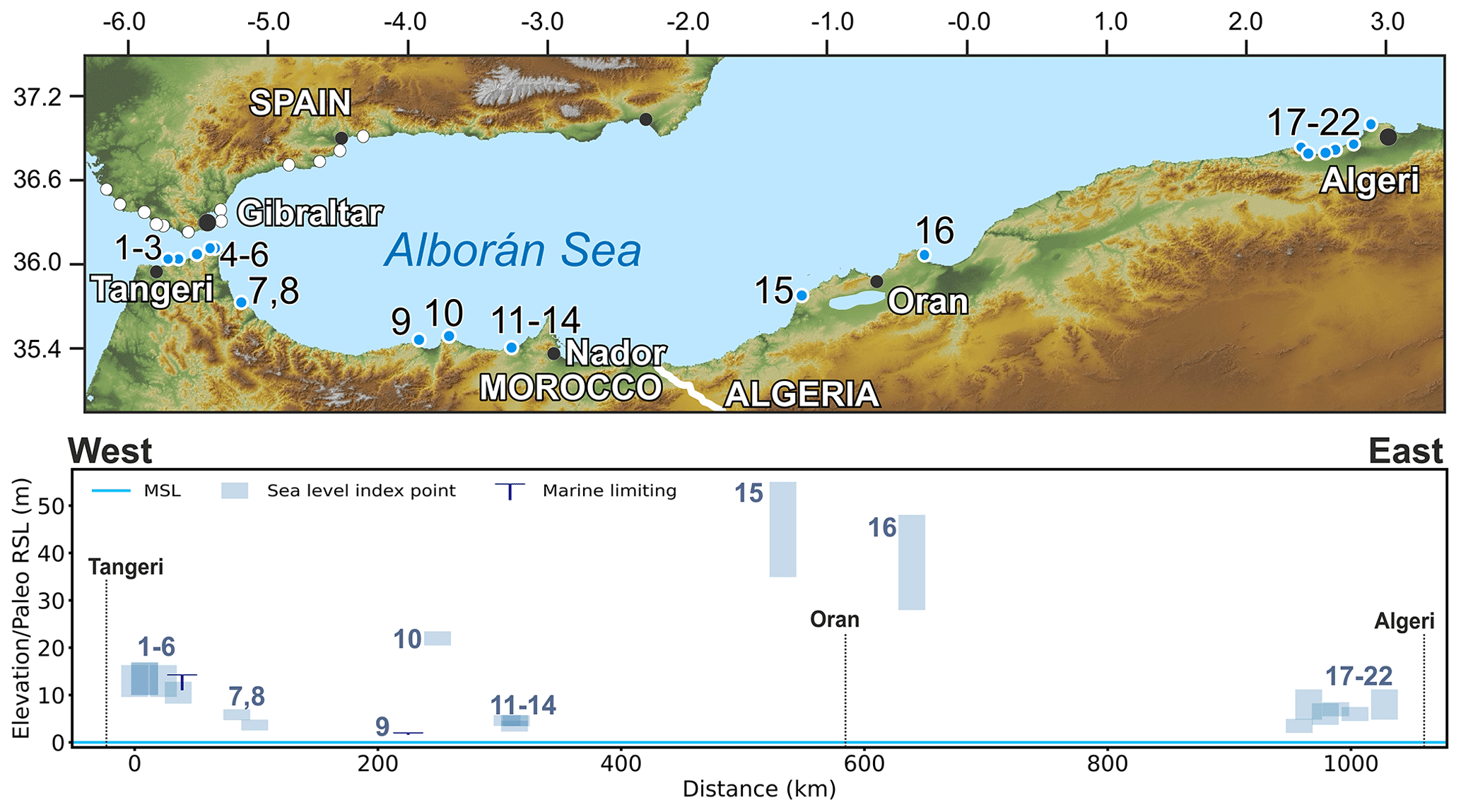
Figure 35Last Interglacial sea-level data for Algeria and Morocco. Upper panel: map of sites. Red dots are sites in the region of interest, and white dots are other sites within the western Mediterranean compilation. The topography has been obtained from the SRTM void-filled DEM (Farr et al., 2007, NASA dataset). Lower panel: distance/elevation graph, from west (left) to east (right). Sites list: 1: Hejar Lasfar marine terrace (RSL ID 3599); 2: Dhada marine terrace S2 (RSL ID 248); 3: Dhada marine terrace S3 (RSL ID 249); 4: Zhâra marine terrace (RSL ID 3598); 5: Cape Leona Section C (RSL ID 260); 6: Bel Younech Beach Section A (RSL ID 259); 7: Laskrine (RSL ID 4073); 8: Aouchtame (RSL ID 4074); 9: Al Hoceima (RSL ID 929); 10: Rastarf Cape Al-Hoceima (RSL ID 3622); 11: Beni Said (RSL ID 4075); 12: Ifri Ifounassene (RSL ID 4076); 13: Ifri Ifounassene (II) (RSL ID 4077). 14 Ifri Ifounassene (III) (RSL ID 4078); 15: Cap Figalo (RSL ID 12); 16: Arzew (RSL ID 11); 17: Chenoua Transect AT1 (RSL ID 4); 18: Tipasa Transect AT2 (RSL ID 5); 19: Tipasa Transect AT2' (RSL ID 7); 20: Bou Haroun Transect AT3 (RSL ID 6); 21: Mazafran Transect AT4 (RSL ID 8); 22: Ain Benian Transect AT5 (RSL ID 9).
7.5 Algeria
One of the earliest reports of Pleistocene deposits in Algeria (Fig. 35) is contained in a paper written in 1911 by de Lamothe (de Lamothe, 1911). In the 1960s, this early study was further expanded upon by Stearns and Thurber (1965) and Vita-Finzi (1967) and later by Saoudi (1989). In the 1990s, studies on the tectonics of Algeria used Last Interglacial shorelines to calculate vertical tectonic rates (Meghraoui et al., 1996), an approach that has continued in more recent times (Maouche et al., 2011). The most recent study related to the Last Interglacial sea-level indicators in Algeria was done by Authemayou et al. (2016), who focused on the record in Tipasa province, west of Algiers. The sea-level information reviewed for Algeria was extracted from two studies: Authemayou et al. (2016) for the Tipasa area and Meghraoui et al. (1996) for the areas of Oran and Ain Techmouchent.
7.5.1 Tipasa
In Tipasa province, Authemayou et al. (2016) identified six sites from which cross sections were extracted and beach deposits were sampled. To measure elevations, the authors used a combination of the SPOT digital elevation model (20 m vertical accuracy) and a barometric altimeter. No detailed stratigraphic description of the beach deposits is given other than their characterization as “shelly sandstone units”. Mollusk samples for U-series radiometric dating were collected from what Atemayou et al. (2016) call “Terrace 1”. Three U-series ages, identified by the original authors as Age ID no. 4, Age ID no. 21, and Age ID no. 48 are reported. Age ID no.4 was done on a sample taken from the profile AT1 (Chenoua, RSL ID 4, no. 17 in Fig. 35) and gives an age of 67 ka. Age ID no. 21 was taken from the profile AT3 (Boun Haroun, RSL ID 6, no. 20 in Fig. 35) and gives an age of 102 ka. Age ID no. 48 was taken from AT5 (Ain Benian, RSL ID 9, no. 22 in Fig. 35) and gives an age of 130.5 ka (+4.5/−4.3). Other ages correlated with Terrace 1 come from Tipasa (AT2 and AT2', respectively, RSL IDs 5 and 7, nos. 18 and 19 in Fig. 35) and were published by Stearns and Thurber (1965). They report U-series ages of 140±10 ka (sample L-779a) and 125±10 ka (sample L-779B); however, radiometric data are not available and were not inserted into the database. The samples were taken from what the original authors called “low-Quaternary beach deposits”.
Maouche et al. (2011) suggested that “Terrace 1” in the area of Tipasa is located at 175–185 m a.s.l., at odds with other descriptions of this terrace. Subsequent comments and replies (Pedoja et al., 2013; Maouche et al., 2013) did not clarify this controversy, until the work of Authemayou et al. (2016), where it seems clear that “Terrace 1” is located only up to 10 m a.s.l.
7.5.2 Oran and Ain Techmouchent
In Oran and Ain Techmouchent provinces, the Last Interglacial terrace is reported by Meghraoui et al. (1996) in a table within the paper, with elevations derived most likely from topographic maps (Arzew, RSL ID 11, and Cap Figalo, RSL ID 12, nos. 16 and 15, respectively, in Fig. 35). The only chronologic constraint that points to Last Interglacial age is the reported presence, on these terraces, of P. latus, which gives a tentative chronostratigraphic correlation with “Terrace 1” in the Tipasa province deposits where the same species was found.
7.6 Morocco
The Quaternary marine terraces cropping out along the Mediterranean Moroccan coasts (Fig. 35) testify to the uplift of this region during the Quaternary (El Gharbaoui, 1977). However, they have not been studied as deeply as their counterparts on the Spanish coast. Pieces of evidence of the Last Interglacial from Tangier to Pointe Ciress have been related to paleo shorelines between 8 and ∼ 20 m a.s.l (Cadet et al., 1977; El Fahssi, 1999; Poujol et al., 2014), whereas the marine Achakkar terrace at 6 m a.s.l. (Brébion et al., 1986) nearby Tangier on the Atlantic side was constrained to the Last Interglacial (120±10 ka) by U series on mollusk shells by Stearns and Thurber (1965). One of the first attempts to date the marine terraces along the Mediterranean coast of Morocco was performed by Brückner (1986) by integration of U-series, AAR, TL, and ESR dating.
7.6.1 The Dhâda terrace
The Dhâda terrace (RSL IDs 248 and 249, nos. 2 and 3 in Fig. 35) has been identified between 13 and 15 m a.s.l. and was characterized by El Abdellaoui et al. (2016). The terrace, which extends for about 1 km along the coast, is made up of marine sands within shell fragments and eolian deposits. El Abdellaoui et al. (2016) recognized two transgressive phases related to the Last Interglacial (MIS 5e) based on four U-series datings on Dendrophyllia ramea (Linnaeus) corals. The age provided for the Dhâda terrace must be considered a minimum age because of the high 234U 238U activity ratio of the dated corals. The uranium ratio indicates that the coral samples have been rejuvenated. Moreover, the authors reject a U-series age obtained from Lithothamnion calcareum algae sampled (U-series ID 2943) within the same unit of the corals, considered rejuvenated by uranium uptake. Such dating (U-series IDs 546 to 549) allowed El Abdellaoui et al. (2016) to stratigraphically correlate the Zhâra (RSL ID 3598, no. 4 in Fig. 35) and Hejar-Lasfar (RSL ID 3599, no. 1 in Fig. 35) marine terraces, located, respectively, a few kilometers eastward and westward of the Dhâda terrace, with MIS 5e. The inner edge of the Zhâra and Hejar-Lasfar terraces is in the 13–14 m elevation range.
7.6.2 Cape Leona
The first attempt to date the Cape Leona staircase sequence of marine terraces was proposed by El Kadiri et al. (2010) by correlation with the U-series-dated travertines at the nearby Beni Younech site (RSL ID 259, no. 6 in Fig. 35). Such correlation is supported by El Kadiri et al. (2010) by geochronological and topographic comparison between the Cape Leona and Moroccan Atlantic coastal marine terraces (El Fahssi, 1999). However, in the same area, Abad et al. (2013) have U-series-dated flowstones covering marine sediments. The data from Abad et al. (2013) provide a marine-limiting point (RSL ID 259, no. 6 in Fig. 35) for the MIS 5e highstand at ∼ 14 m a.s.l. and help to correlate a tidal notch (RSL ID 260, no. 5 in Fig. 35) at ∼ 10 m a.s.l. with MIS 5a. We note that the notch at 10 m has been assigned to MIS 5a by geomorphological correlation with a beach deposit bearing calcareous algae dated ∼ 84 ka (U-series ID 554) but, according to El Abdellaoui et al. (2016), such dating is not reliable because of rejuvenation processes occurring in calcareous algae, as evidenced for the Dhâda terrace (see the previous paragraph).
Southeastward of Cape Leona, at the Laskrine and Auchtame sites (RSL IDs 4073 and 4074, nos. 7 and 8 in Fig. 35), MIS 5e was constrained by Brückner (1986) based on the integration of U-series and TL dating between 4 and 6 m a.s.l.
7.6.3 Al-Hoceima
The Al-Hoceima region is situated at the eastern edge of the Mediterranean Moroccan coasts. At Al-Hoceima (RSL ID 929, no. 9 in Fig. 35), Hearty (1986) dated marine deposits (AAR ID 195) bearing Glycimeris glycimeris and reported the occurrence of Senegalese fauna with P. latus. The inner edge of the marine terrace related to MIS 5e was assessed by Poujol et al. (2014) at 22±1 m a.s.l. (RSL ID 3622, no. 10 in Fig. 35). Such correlation is based on U-series dating on corals (U-series IDs 2952 and 2953) and P. Latus (U-series IDs 2954 and 2955) from the MIS 7 marine terrace. However, it is worth noting that the samples of Poujol et al. (2014) are affected by chemical weathering.
A few kilometers eastwards of the Al-Hoceima site, Brückner (1986) reported the presence of P. latus and Senegalese fauna up to 5 m a.s.l. at the Beni Said (RSL ID 4075, no. 11 in Fig. 35) and Ifri Ifounassene (RSL ID 4076, no. 12 in Fig. 35) sites. The correlation of such terraces with MIS 5e is also confirmed by ESR dating on a snail in Ifri Ifonaussene (III) (RSL ID 4078, no. 14 in Fig. 35), while U-series dating on a snail allowed Brückner (1986) to correlate the marine terrace up to 3.75 m in Ifri Ifounassene (II) (RSL ID 4077, no. 13 in Fig. 35) with MIS 5a.
The western Mediterranean sea-level database is available as open access and is kept updated as necessary at this link: https://doi.org/10.5281/zenodo.5341661 (Cerrone et al., 2021b). The files at this link were exported from the WALIS database interface on 3 February 2021. A description of each field in the database is contained at the link https://doi.org/10.5281/zenodo.3961544 (Rovere et al., 2020), which is readily accessible and searchable here: https://walis-help.readthedocs.io/en/latest/ (last access: 30 July 2021). More information on the World Atlas of Last Interglacial Shorelines (WALIS, 2021) can be found here: https://warmcoasts.eu/world-atlas.html (last access: 30 July 2021). A summary of all sea-level data points included in the database is annexed to this paper. Users of our database are encouraged to cite the original data sources alongside our database and this article. The background topography for geographic images has been obtained from the Shuttle Radar Topography Mission void-filled DEM (Farr et al., 2007, https://doi.org/10.1029/2005RG000183).
Our database and the regional descriptions associated with it show that MIS 5 sea-level proxies have been preserved at several sites along the coasts of the western Mediterranean in different geological facies. In stable to slowly uplifting sites, beach deposits containing warmer-water faunal assemblages can be found a few meters above the present sea level or inside coastal caves. Along uplifted coasts, marine terraces (locally capped by coastal or marine deposits) mark the Last Interglacial transgression, which is instead found as a transgressive sequence in cores drilled in subsiding areas. In uplifting and subsiding coastal tracts, the RSL information we compiled might support the definition of long-term vertical motion rates, albeit we note that these should be calculated accounting for two main potential issues. One is the underlying assumption that any land motion rate calculated from Last Interglacial RSL proxies is necessarily assumed to be continuous, which might not be the case in areas affected by high seismicity (e.g., along the southern coasts of Italy) or subsidence (e.g., the Po coastal plain). The second is that, to calculate land motion rates from Last Interglacial sea-level proxies, large uncertainties stem from both Last Interglacial global mean sea-level estimates and glacial isostatic adjustment processes, which have to be accounted for before calculating long-term rates.
Areas that are traditionally considered tectonically stable, such as the islands of Sardinia (Italy), Corsica (France), and Mallorca (Spain), might provide benchmarks to evaluate glacial isostatic adjustment models and Last Interglacial global mean sea-level scenarios for the western Mediterranean region. Overall, MIS 5e proxies at these sites seem to indicate that paleo RSL included between 3 and 9 m above the present day.
Besides MIS 5e, several locations (especially in uplifted areas) preserved remnants of MIS 5a and 5c sea-level proxies (that were also inserted into the database) and former interglacials. For example, Zazo et al. (2013) report terraces attributed to MIS 7, MIS 9, and MIS 11 along the Spanish coasts. Based on different dating techniques and a volcanic ash layer, Brückner (1980) assigned the staircased marine terraces bordering the Gulf of Taranto to the interglacials MIS 1 to MIS 19. Recent studies on cave deposits in Mallorca allowed placement of important benchmarks on Early Pleistocene and Pliocene highstands (Dumitru et al., 2021a; Dumitru et al., 2019). Similarly, marine overgrowth on speleothems collected from the Argentarola cave, in Italy, allowed us to establish minimum positions of sea level during the penultimate interglacial (MIS 7, Dutton et al., 2009b; Bard et al., 2002). At the moment, a standardized review of pre-MIS 5 sea-level proxies is not available. Instead, Holocene sea-level studies were compiled within a single database (Vacchi et al., 2016, 2018) following the standardized template of Khan et al. (2019). These recent reviews summarized the large tradition of studies related to Holocene sea-level proxies in this part of the Mediterranean basin (see Lambeck et al., 2004, for an overview).
While many western Mediterranean MIS 5 sites are often characterized by geological units with narrow indicative ranges (which is also reflected by the relatively high number of sites that were assigned above-average RSL quality scores during the compilation), there has been a lack of precise measurement and datum attribution, which researchers started to address only recently (e.g., Stocchi et al., 2018; Lorscheid et al., 2017; Muhs et al., 2015; Antonioli et al., 2018). As sea-level studies progress in the western Mediterranean, it is imperative that the elevation of the most relevant outcrops is re-measured with accurate instrumentation (e.g., differential GNSS systems) and that elevations are referred to well-defined sea-level datums. Another key requirement for future studies is the re-assessment of modern analog landforms and deposits near the Last Interglacial ones. In our compilation, we used in large part the ex situ values extracted from the IMCalc software (Lorscheid and Rovere, 2019), but these cannot be considered as accurate as in situ modern analogs.
Another issue that is common within western Mediterranean MIS 5 proxies is the paucity of reliable radiometric ages. This is in part compensated with correlations between sites supported by (bio)stratigraphic and amino acid racemization correlations, but this hinders the possibility of detailing intra–interglacial dynamics, such as the presence and timing of sea-level fluctuations. While it is indeed considered possible that some Mediterranean sites recorded MIS 5e sea-level fluctuations (e.g., Hearty et al., 2007), these are often inferred from either superimposed deposits with slightly different AAR ratios or from the concurrent presence of lower deposit and upper notches (that can only be dated indirectly). In this context, future studies should aim at obtaining more reliable ages at sites where the MIS 5e stratigraphy points to sea-level fluctuations. This is of particular importance for the southern coasts of France and Corsica, where the age of several potentially relevant Last Interglacial outcrops was never corroborated by robust and state-of-the-art dating techniques. These coastal zones, mostly occurring in regions with minimal or negligible neotectonics, have the potential to provide important insights into the magnitude and sea-level fluctuations within MIS 5e in the western Mediterranean.
A particular situation characterizes the coastal plains of the northwestern Adriatic Sea where, because of the regional subsiding setting, deposits related to MIS 5e are found at considerable depth. Despite the limited accessibility through stratigraphic cores, they allow investigation of the 3D relations existing between different sedimentary facies formed during the marine transgression. In this area, the chronostratigraphy is mainly based on pollen analyses which correlate with the Eemian paleobotanic assemblages recognized in other European regions.
Gathering more reliable ages would also help solve several scientific debates over different sites (the main ones were briefly summarized in the regional descriptions above) as well as the long-lasting debate over the presence, in the western Mediterranean, of Senegalese fauna (and, in particular, P. latus) also in stages other than MIS 5. For the issue of differentiating between different sea-level peaks within MIS 5e, the scarcity of well-preserved corals and the high uncertainties associated with other dating methods make such an endeavor a very challenging one for the western Mediterranean, leaving the differentiation of ages to the geological interpretation of co-occurring units within the same outcrop.
The supplement related to this article is available online at: https://doi.org/10.5194/essd-13-4485-2021-supplement.
All the authors compiled the database and wrote the manuscript jointly. CC curated data entries and text for southern Italy and the southern portion of the western Mediterranean (Algeria and Morocco). MV curated data entries and text for France, Corsica, and Sardinia. AF curated data entries and text for the Adriatic Sea. AR curated data entries and text for Spain and Tyrrhenian northern Italy.
Alessio Rovere is the topical editor of Earth System Science Data.
Publisher’s note: Copernicus Publications remains neutral with regard to jurisdictional claims in published maps and institutional affiliations.
This article is part of the special issue “WALIS – the World Atlas of Last Interglacial Shorelines”.
The data used in this study were compiled in WALIS, a sea-level database interface developed by ERC Starting Grant “WARMCOASTS” (StG-802414) in collaboration with the PALSEA (PAGES/INQUA) working group. The database structure was designed by Alessio Rovere, Deirdre Ryan, Colin Murray-Wallace, Alexander Simms, Matteo Vacchi, Andrea Dutton, Thomas Lorscheid, Peter Chutcharavan, Dominik Brill, Melanie Bartz, Nathan Jankowski, Daniela Mueller, Kim Cohen, and Evan Gowan. The data points used in this study were contributed to WALIS by Ciro Cerrone, Matteo Vacchi, Alessandro Fontana, and Alessio Rovere. The authors thank the National Aeronautics and Space Administration (NASA) for the free use of SRTM (Shutter Radar Topography Mission) data.
Alessio Rovere is supported by the European Research Council, H2020 European Research Council (WARMCOASTS – Sea level and extreme waves in the Last Interglacial, grant no. Stg-802414).
This paper was edited by Colin V. Murray-Wallace and reviewed by Helmut Brückner and Colin V. Murray-Wallace.
Abad, M., Rodríguez-Vidal, J., Aboumaria, K., Zaghloul, M. N., Cáceres, L. M., Ruiz, F., Martínez-Aguirre, A., Izquierdo, T., and Chamorro, S.: Evidence of MIS 5 sea-level highstands in Gebel Mousa coast (Strait of Gibraltar, North of Africa), Geomorphology, 182, 133–146, https://doi.org/10.1016/j.geomorph.2012.11.004, 2013.
Abate, B., Di Maggio, C., Incandela, A., and Renda, P.: Nuovi dati sulla geologia della penisola di Capo San Vito (Sicilia NW), Memorie Società Geologica Italiana, 47, 15–25, 1991.
Abate, B., Ferrini, G., Incandela, A., and Renda, P.: Ritrovamento di depositi a Strombus bubonius nell'isola di Favignana, Rivista Mineraria Siciliana, 162, 37–46, 1992.
Abate, B., Di Maggio, C., Incandela, A., and Renda, P.: Carta geologica dei Monti di Capo San Vito, scala 1 : 25 000, Dipartimento di Geologia e Geodesia dell'Università di Palermo, 1993.
Abate, B., Buccheri, G., Renda, P., and Incandela, A.: Le Sezioni Tirreniane delle località La Conca e Punta Libeccio (Isola di Marettimo-Arcipelago delle Egadi, Sicilia N-O), Indagini stratigrafica e paleoecologica, Bollettino Società Geologica Italiana, 115, 145–158, 1996.
Albrecht, P. and Mosetti, F.: Karst evolution and sea level, Memorie Società Geologica Italiana, 40, 383–387, 1987.
Allen, J. R. M., Brandt, U., Brauer, A., Hubberten, H. W., Huntley, B., Keller, J., Kraml, M., Mackensen, A., Mingram, J., Negendak, J. F. W., Nowaczyk, N. R., Oberhänsli, H., Watts, W. A., Wulf, S., and Zolitschka, B.: Rapid environmental changes in southern Europe during the last glacial period, Nature, 400, 740–743, 1999.
Ambert, P.: Les formations littorales pléistocènes du Languedoc [Pleistocene shorelines of Languedoc], Quaternaire, 10, 83–93, https://doi.org/10.3406/quate.1999.1633, 1999.
Amorosi, A., Colalongo, M. L., Pasini, G., and Preti, S.: Sedimentary response to Late Quaternary sea-level changes in the Romagna coastal plain (northern Italy), Sedimentology, 46, 99–121, https://doi.org/10.1046/j.1365-3091.1999.00205.x, 1999.
Amorosi, A., Colalongo, M. L., Fiorini, F., Fusco, F., Pasini, G., Vaiani, S. C., and Sarti, G.: Palaeogeographic and palaeoclimatic evolution of the Po Plain from 150-ky core records, Global Planet. Change, 40, 55–78, https://doi.org/10.1016/s0921-8181(03)00098-5, 2004.
Amorosi, A., Maselli, V., and Trincardi, F.: Onshore to offshore anatomy of a late Quaternary source-to-sink system (Po PlainAdriatic Sea Italy), Earth-Sci. Rev., 153, 212–237, https://doi.org/10.1016/j.earscirev.2015.10.010, 2016.
Amorosi, A., Fontana, A., Antonioli, F., Primon, S., and Bondesan, A.: Post-LGM sedimentation and Holocene shoreline evolution in the NW Adriatic coastal area, GeoActa, 7, 41–67, available at: https://www.scopus.com/inward/record.uri?eid=2-s2.0-69249239331&partnerID=40&md5=08ea5323ae7f00a626efe15b6336921a (last access: 30 July 2021), 2008a.
Amorosi, A., Pavesi, M., Lucchi, M. R., Sarti, G., and Piccin, A.: Climatic signature of cyclic fluvial architecture from the Quaternary of the central Po Plain Italy, Sediment. Geol., 209, 58–68, https://doi.org/10.1016/j.sedgeo.2008.06.010, 2008b.
Amorosi, A., Antonioli, F., Bertini, A., Marabini, S., Mastronuzzi, G., Montagna, P., Negri, A., Rossi, V., Scarponi, D., Taviani, M., Angeletti, L., Piva, A., and Vai, G. B.: The Middle-Upper Pleistocene Fronte Section (Taranto, Italy): An exceptionally preserved marine record of the Last Interglacial, Global Planet. Change, 119, 23–38, https://doi.org/10.1016/j.gloplacha.2014.04.007, 2014.
Andreucci, S., Pascucci, V., Murray, A. S., and Clemmensen, L. B.: Late Pleistocene coastal evolution of San Giovanni di Sinis, west Sardinia (Western Mediterranean), Sediment. Geol., 216, 104–116, 2009.
Andreucci, S., Clemmensen, L. B., Murray, A. S., and Pascucci, V.: Middle to late Pleistocene coastal deposits of Alghero northwest Sardinia (Italy): Chronology and evolution, Quatern. Int., 222, 3–16, https://doi.org/10.1016/j.quaint.2009.07.025, 2010.
Antonioli, F., Dai Pra, G., and Hearty, P. J.: I sedimenti quaternari nella fascia costiera della Piana di Fondi (Lazio meridonale), Bollettino della Societa Geologica Italiana, 107, 491–501, 1988.
Antonioli, F., Girotti, O., Improta, S., Nisi, M. F., Puglisi, C., and Verrubbi, V.: Nuovi dati sulla trasgressione marina olocenica nella pianura versiliese, in Proceedings of the Meeting “Le Pianure”, Ferrara, 214–218, 1999a.
Antonioli, F., Silenzi, S., Vittori, E., and Villani, C.: Sea level changes and tectonic mobility: Precise measurements in three coastlines of Italy considered stable during the last 125 ky, Phys. Chem. Earth Pt. A, 24, 337–342, https://doi.org/10.1016/s1464-1895(99)00038-1, 1999b.
Antonioli, F., Cinque, A., Ferranti, L., and Romano, P.: Emerged and submerged quaternary marine terraces of Palinuro Cape (southern Italy), Memorie Descrittive Carta Geologica d'Italia, LII, 237–260, 1994a.
Antonioli, F., Belluomini, G., Ferranti, L., Improta, S., and Reitano, G.: Il sito preistorico dell'arco naturale di Capo Zafferano (Sicilia), Aspetti geomorfologici e relazione con le variazioni del livello marino olocenico, Il Quaternario, 7, 109–118, 1994b.
Antonioli, F., Cremona, G., Immordino, F., Puglisi, C., Romagnoli, C., Silenzi, S., Valpreda, E., and Verrubbi, V.: New data on the Holocenic sea-level rise in NW Sicily (Central Mediterranean Sea), Global Planet. Change, 34, 121–140, https://doi.org/10.1016/S0921-8181(02)00109-1, 2002.
Antonioli, F., Lambeck, K., Kershaw, S., Rust, D., Sylos Labini, S., Segre, A. G., Verrubbi, Belluomini, G., Dai Pra, G., Ferranti, L., Improta, S., and Vesica, P.: Evidence for non-uniform uplift rates in southern Italy (Calabria and eastern Sicily: Taormina, St. Alessio, Ganzirri, Scilla, Ioppolo, Capo Rizzuto) on glacialcycle timescales, Quaternaria Nova, VIII, 187–192, 2004.
Antonioli, F., Kershaw, S., Renda, P., Rust, D., Belluomini, G., Cerasoli, M., Radtke, U., and Silenzi, S.: Elevation of the last interglacial highstand in Sicily (Italy): A benchmark of coastal tectonics, Quatern. Int., 145–146, 3–18, https://doi.org/10.1016/j.quaint.2005.07.002, 2006.
Antonioli, F., Ferranti, L., Fontana, A., Amorosi, A., Bondesan, A., Braitenberg, C., Dutton, A., Fontolan, G., Furlani, S., Lambeck, K., Mastronuzzi, G., Monaco, C., Spada, G., and Stocchi, P.: Holocene relative sea-level changes and vertical movements along the Italian and Istrian coastlines, Quatern. Int., 206, 102–133, https://doi.org/10.1016/j.quaint.2008.11.008, 2009.
Antonioli, F., D'Orefice, M., Ducci, S., Firmati, M., Foresi, L. M., Graciotti, R., Pantaloni, M., Perazzi, P., and Principe, C.: Palaeogeographic reconstruction of northern Tyrrhenian coast using archaeological and geomorphological markers at Pianosa island (Italy), Quatern. Int., 232, 31–44, https://doi.org/10.1016/j.quaint.2010.03.017, 2011.
Antonioli, F., Lo Presti, V. L., Rovere, A., Ferranti, L., Anzidei, M., Furlani, S., Mastronuzzi, G., Orru, P. E., Scicchitano, G., Sannino, G., Spampinato, C. R., Pagliarulo R., Deiana, G., de Sabata, E., Sansò, P., Vacchi, M., and Vecchio, A.: Tidal notches in Mediterranean Sea: a comprehensive analysis, Quaternary Sci. Rev., 119, 66–84, 2015.
Antonioli, F., Ferranti, L., Stocchi, P., Deiana, G., Presti, V. L., Furlani, S., Marino, C., Orru, P., Scicchitano, G., Trainito, E., Anzidei, M., Bonamini, M., Sansò, P., and Mastronuzzi, G.: Morphometry and elevation of the last interglacial tidal notches in tectonically stable coasts of the Mediterranean Sea, Earth-Sci. Rev., 185, 600–623, 2018.
Authemayou, C., Pedoja, K., Heddar, A., Molliex, S., Boudiaf, A., Ghaleb, B., Lanoe, B. V. V., Delcaillau, B., Djellit, H., Yelles, K., and Nexer, M.: Coastal uplift west of Algiers (Algeria): pre- and post-Messinian sequences of marine terraces and rasas and their associated drainage pattern, Int. J. Earth Sci., 106, 19–41, https://doi.org/10.1007/s00531-016-1292-5, 2016.
Baena, J., Goy, J. I., and Zazo C.: Litoral de Almería, in: Union Internationale pour l'etude du Quaternaire, Commission Lignes de Rivages, Sous-Commission Méditerranée – Mer Noire, Excursion – Table Ronde sur le Tyrrhénien d'Espagne (2–9 Septembre 1981), edited by: Aguirre, E., 1981.
Balescu, S., Dumas, B., Guérémy, P., Lamothe, M., Lhenaff, R., and Raffy, J.: Thermoluminescence dating tests of Pleistocene sediments from uplifted marine shorelines along the southwest coastline of the Calabrian Peninsula (southern Italy), Palaeogeogr. Palaeoclim., 130, 25–41, https://doi.org/10.1016/S0031-0182(96)00119-8, 1997.
Bard, E., Antonioli, F., and Silenzi, S.: Sea-level during the penultimate interglacial period based on a submerged stalagmite from Argentarola Cave (Italy), Earth Planet. Sc. Lett., 196, 135–146, 2002.
Bardají, T., Civis, J., Dabrio, C. J., Goy, J. L., and Somoza, L.: Geomorfología y estratigrafía de las secuencías marinas y continentales cuaternarias de la Cuenca de Cope, Murcia, España, in: Estudios sobre Geomorfología del Sur de España, Universidad de Murcia, 11–16, 1986.
Bardají, T., Goy, J. L., Zazo, C., Hillaire-Marcel, C., Dabrio, C. J., Cabero, A., Ghaleb, B., Silva, P. G., and Lario, J.: Sea level and climate changes during OIS 5e in the Western Mediterranean, Geomorphology, 104, 22–37, https://doi.org/10.1016/j.geomorph.2008.05.027, 2009a.
Bardají, T., Goy, J. L., Zazo, C., Hillaire-Marcel, C., Dabrio, C. J., Cabero, A., Ghaleb, B., Silva, P. G., and Lario, J.: Reply to the comments by Mauz B. and Antonioli, F. on Sea Level and Climate Changes during OIS 5e in the Western Mediterranean, Geomorphology, 110, 231–235, https://doi.org/10.1016/j.geomorph.2009.05.007, 2009b.
Bardají, T., Cabero, A., Lario, J., Zazo, C., Silva, P. G., Goy, J. L., and Dabrio, C. J.: Coseismic vs. climatic factors in the record of relative sea level changes: an example from the Last Interglacials in SE Spain, Quaternary Sci. Rev., 113, 60–77, https://doi.org/10.1016/j.quascirev.2014.10.005, 2015.
Barra, D., Cinque, A., Gewelt, M., and Hurtgen, C.: L'ospite caldo Sylvestra seminis (Bonaduce, Masoli and Pugliese, 1976) (Crustacea, Ostracoda): un possibile marker dell'Ultimo Interglaciale dell'area Mediterranea, Il Quaternario, 4, 327–332, 1991.
Barrière, J.: Le rivage tyrrhénén de létang de Bages et de Sigean (Aude), Bulletin de l'Association française pour létude du quaternaire, 3, 251–283, https://doi.org/10.3406/quate.1966.1046, 1966.
Belluomini, G. and Delitala, L.: Amino acid racemization dating of Quaternary deposits of Central and Southern Italy, Org. Geochem., 13, 735–740, 1988.
Belluomini, G., Branca, M., Delitala, L., Pecorini, G., and Spano, C.: Isoleucine epimerization dating of Quaternary marine deposits in Sardinia, Italy in Dating Mediterranean shorelines, Z. Geomorphol., 62, 109–117, 1986.
Belluomini, G., Gliozzi, E., Ruggieri, G., Branca, M., and Delitalia, L.: First dates on the terraces of the Crotone Peninsula (Calabria, Southern Italy), Bollettino Società Geologic Italiana, 107, 249–254, 1988.
Benjamin, J., Rovere, A., Fontana, A., Furlani, S., Vacchi, M., Inglis, R. H., Galili, E., Antonioli, F., Sivan, D., Miko, S., Mourtzas, N., Felja, I., Meredith-Williams, M., Goodman-Tchernov, B., Kolaiti, E., Anzidei, M., and Gehrels, R.: Late Quaternary sea-level changes and early human societies in the central and eastern Mediterranean Basin: An interdisciplinary review, Quatern. Int., 449, 29–57, 2017.
Bernat, M., Bousquet, J. C., and Dars, R.: Io–U dating of the Ouljian stage from Torre Garcia (southern Spain), Nature, 275, 302–303, 1978.
Bernat, M., Echallier, J. C., and Bousquet, J. C.: Nouvelles datations Io-U sur des Strombes du dernier Interglaciaire en Mediterranée (La Marina, Espagne) et implications geologiques, Comptes rendus des seances de l'academie de Sciences de Paris, II-295, 1982.
Bianca, M., Monaco, C., Tortorici, L., and Cernobori, L.: Quaternary normal faulting in southeastern Sicily (Italy): A seismic source for the 1693 large earthquake, Geophys. J. Int., 139, 370–394, https://doi.org/10.1046/j.1365-246X.1999.00942.x, 1999.
Bianca, M., Catalano, S., De Guidi, G., Gueli, A. M., Monaco, C., Ristuccia, G. M., Stella, G., Tortorici, G., Tortorici, L., and Troja, S. O.: Luminescence chronology of Pleistocene marine terraces of Capo Vaticano peninsula (Calabria, Southern Italy), Quatern. Int., 232, 114–121, https://doi.org/10.1016/j.quaint.2010.07.013, 2011.
Bini, M., Zanchetta, G., Drysdale, R. N., Giaccio, B., Stocchi, P., Vacchi, M., Hellstrom, J. C., Couchoud, I., Monaco, L., Ratti, A., Martini, F., and Sarti, L.: An end to the Last Interglacial highstand before 120 ka: Relative sea-level evidence from Infreschi Cave (Southern Italy), Quaternary Sci. Rev., 250, 106658, https://doi.org/10.1016/j.quascirev.2020.106658, 2020.
Blanc, G. A.: Grotta Romanelli I. Stratigrafia dei depositi e natura e origine di essi, Archivio per l'Antropologia e l'Etnologia, 50, 1–39, 1920.
Blanc, G. A.: Grotta Romanelli. Dati ecologici e paleontologici, Archivio per l'Archeologia e l'Etnologia, 58, 1–50, 1928.
Blanc, A. C.: Stratigrafia del Canale Mussolini nell'Agro Pontino, Atti della Società Toscana di Scienze Naturali, XLIV(2), 1935.
Blanc, A. C.: Una spiaggia pleistocenica a Strombus bu bonius presso Palidoro (Roma), Ist. Ital. di Antropologia, 1936.
Blanc, A. C. and Segre, A. G.: Nuovi giacimenti tirreniani e paleolitici sulla costiera tra Sperlonga e Gaeta, Historia Naturalis, 2, 1–2, 1947.
Blanc, A. C. and Segre, A. G.: Excursion au Mont Circé, in: 4th Conf. Int. Assoc. Quatern. Res. Rome-Pisa, 87–106, 1953.
Boenzi, F., Caldara, M., and Pennetta, L.: (The Tyrrhenian transgression in the Castellaneta environs, Taranto, Italy), Geologia Applicata e Idrogeologia, 20, 163–175, 1985.
Bonadonna, F. P.: Studi sul Pleistocene del Lazio. III. Linee di costa lungo il litorale di Tarquinia (Lazio settentrionale), Geologica Romana, 6, 131–135, 1967a.
Bonadonna, F. P.: Studi sul pleistocene del Lazio; IV, La linea di costa tirreniana di Ponte Galeria (Roma), Quaternaria, 9, 285–299, 1967b.
Bonfiglio, L. and Violanti, L.: Prima segnalazione di Tirreniano ed evoluzione Pleistocenica del Capo Peloro (Sicilia Nord-Orientale), Geografia Fisica Dinamica Quaternaria, 6, 3–15, 1983.
Bonfiglio, L.: Terrazzi marini e depositi continentali quaternari di Taormina (Sicilia), Quaternaria, 1981.
Bonifay, E. and Mars, P.: Le Tyrrhénien dans le cadre de la chronologie quaternaire mediterranéenne, Bulletin de la Société Géologique de France, S7-I, 62–78, https://doi.org/10.2113/gssgfbull.s7-i.1.62, 1959.
Bordoni, P. and Valensise, G.: Deformation of the 125 ka marine terrace in Italy: tectonic implications, Geol. Soc. Spec. Publ., 146, 71–110, https://doi.org/10.1144/GSL.SP.1999.146.01.05, 1999.
Boschian, G., Bossio, A., Dallantonia, B., and Mazzanti, R.: Il Quaternario della Toscana Costiera, Studi Costieri, 12, 208 pp., 2006.
Bracchi, V. A., Nalin, R., and Basso, D.: Persistrombus latus-bearing deposits south of Isola di Capo Rizzuto, Calabria (Southern Italy), Il Quaternario – Italian Journal of Quaternary Sciences, 24, 23–25, 2011.
Brancaccio, L., Capaldi, G., Cinque, A., Pece, R., and Sgrosso, I.: Th/U dating of corals from a Tyrrhenian beach in Sorrentine Peninsula (southern Italy), Quaternaria, 20, 175–183, 1978.
Brancaccio, L., Cinque, A., Belluomini, G., Branca, M., and Delitalia, L.: Isoleucine epimerization dating and tectonic significance of Upper Pleistocene sea-level features of the Sele Plain (Southern Italy), Z. Geomorphol., 62, 159–166, 1986.
Brancaccio, L., Cinque, A., D'Angelo, G., Russo, F., Santangelo, N., and Sgrosso, I.: Evoluzione tettonica e geomorfologica della Piana del Sele (Campania, Appennino meridionale), Geografia Fisica e Dinamica Quaternaria, 10, 47–55, 1987.
Brancaccio, L., Cinque, A., Russo, F., Beluomini, G., Branca, M., and Delitalia, L.: Segnalazione e datazione di depositi marini tirreniani sulla costa campana, Bollettino della Società geologica italiana, 109, 259–265, 1990.
Brébion, P., Raynal, J. P., Texier, J. P., and Alouan, M.: Nouvelles données sur le Quaternaire atlantique à Casablanca et Achakar, Comptes Rendus de l'Acadèmie des Sciences, Série II, 302, 901–904, 1986.
Brunović, D., Miko, S., Hasan, O., Papatheodorou, G., Ilijanić, N., Miserocchi, S., Correggiari, A., and Geraga, M.: Late Pleistocene and Holocene paleoenvironmental reconstruction of a drowned karst isolation basin (Lošinj Channel NE Adriatic Sea), Palaeogeogr. Palaeoclim., 544, 109587, https://doi.org/10.1016/j.palaeo.2020.109587, 2020.
Brückner, H.: Marine Terrassen in Süditalien. Eine quartärmorphologische Studie über das Küstentiefland von Metapont – Düsseldorfer Geographische Schriften, Düsseldorf (PhD thesis, monograph), 14, 235 pp., 1980.
Brückner, H.: Stratigraphy, evolution and age of quaternary marine terraces in Marocco and Spain, Z. Geomorphol., 62, 83–101, 1986.
Brückner, H. and Radtke, U.: Paleoclimatic implications derived from profiles along the Spanish Mediterranean coast, in: Symposium on climatic fluctuations during the Quaternary in the Western Mediterranean regions, 467–486, 1986.
Buccheri, G., Renda, P., Morreale, C., and Sorrentino, G.: Il Tirreniano dell'isola di Lampedusa (Arcipelago Pelagiano, Agrigento, Italia), Le successioni di cala Maluk e Cala Uccello, Bollettino Società Geologica Italiana, 118, 361–373, 1999.
Busetti, M., Baradello, L., Caburlotto, A., Gordini, E., Zanolla, C., Accettella, D., Antonioli, F., and Paganini, P.: Indagini geofisiche per lo studio dell'evoluzione Tardo-Pleistocenica ed Olocenica della Laguna di Grado e Marano (Adriatico Settentrionale), Workshop finale Project VECTOR (VulnErability of the Italian coastal area and marine Ecosystems to Climatic changes and Their role in the Mediterranean carbon cycles), Roma, 18–19 October 2010.
Butzer, K. W. and Cuerda, J.: Coastal stratigraphy of southern Mallorca and its implications for the Pleistocene chronology of the Mediterranean Sea, J. Geol., 70, 398–416, 1962.
Cadet, J.-P., Fourniguet, J., Gigout, M., Guillemin, M., and Pierre, G.: Les resultats de l'analyse structurale et de la neotectonique des littoraux; La neotectonique des littoraux, Bulletin de la Société Géologique de France, S7-XIX, 600–605, https://doi.org/10.2113/gssgfbull.S7-XIX.3.600, 1977.
Caldara, M.: La sezione tirreniana di Ponte del Re (Castellaneta Marina, Taranto): analisi paleoecologica, Atti della Società Toscana Scienze Naturali Mem. A XCIII, 129–163, 1987.
Campo, B., Bruno, L., and Amorosi, A.: Basin-scale stratigraphic correlation of late Pleistocene-Holocene (MIS 5e-MIS 1) strata across the rapidly subsiding Po Basin (northern Italy), Quaternary Sci. Rev., 237, 106300, https://doi.org/10.1016/j.quascirev.2020.106300, 2020.
Carboni, M. G., Bergamin, L., Di Bella, L., Esu, D., Cerone, E. P., Antonioli, F., and Verrubbi, V.: Palaeoenvironmental reconstruction of late Quaternary foraminifera and molluscs from the ENEA borehole (Versilian plain, Tuscany, Italy), Quatern. Res., 74, 265–276, 2010.
Carboni, S., Lecca, L., Hillaire-Marcel, C., and Ghaleb, B.: MIS 5e at San Giovanni di Sinis (Sardinia Italy): Stratigraphy, U Th dating and eustatic inferences, Quatern. Int., 328–329, 21–30, https://doi.org/10.1016/j.quaint.2013.12.052, 2014.
Carboni, S. and Lecca, L.: L'archivio stratigrafico del Tirreniano della Sardegna, Rendiconti online della Società Geologica Italiana, 3, 172–173, 2008.
Carminati, E., Doglioni, C., and Scrocca, D.: Apennines subduction-related subsidence of Venice (Italy), Geophys. Res. Lett., 30, 1717, https://doi.org/10.1029/2003gl017001, 2003.
Carobene, L.: Marine Notches and Sea-Cave Bioerosional Grooves in Microtidal Areas: Examples from the Tyrrhenian and Ligurian Coasts Italy, J. Coastal Res., 313, 536–556, https://doi.org/10.2112/jcoastres-d-14-00068.1, 2015.
Carobene, L., Dai Pra, G., and Gewelt, M.: Niveaux marins du Pléistocène moyen-supéerieur de la côte tyrrhénienne de la Calabre (Italie méridionale) Datations 230Th 234U et tectonique récente, Z. Geomorphol., 141–158, 1986.
Carobene, L. and Dai Pra, G.: Genesis, Chronology and Tectonics of the Quaternary marine terraces of the Tyrrhenian coast of northern Calabria (Italy), Their correlation with climatic variations, Il Quaternario, 3, 75–94, 1990.
Carobene, L. and Dai Pra, G.: Middle and Upper Pleistocene sea level highstands along the Tyrrhenian coast of Basilicata (Southern Italy), Il Quaternario, 4, 173–202, 1991.
Casini, L., Andreucci, S., Sechi, D., Huang, C.-Y., Shen, C.-C., and Pascucci, V.: Luminescence dating of Late Pleistocene faults as evidence of uplift and active tectonics in Sardinia, W Mediterranean, Terra Nova, 2020.
Catalano, S. and Guidi, G. D.: Late Quaternary uplift of northeastern Sicily: relation with the active normal faulting deformation, J. Geodynam., 36, 445–467, https://doi.org/10.1016/S0264-3707(02)00035-2, 2003.
Catalano, S., De Guidi, G., Monaco, C., Tortorici, G., and Tortorici, L.: Long-term behaviour of the late Quaternary normal faults in the Straits of Messina area (Calabria arc): structural and morphological constraints, Quatern. Int., 101/102, 81–91, 2003.
Cerrone, C., Ascione, A., Robustelli, G., Balassone, G., Soligo, M., and Tuccimei, P.: Late Quaternary uplift and sea level fluctuations along the Tyrrhenian margin of Basilicata – northern Calabria (southern Italy): New constraints from raised paleoshorelines, Geomorphology, in press, 2021a.
Cerrone, C., Vacchi, M., Fontana, A., and Rovere, A.: Last interglacial sea-level index points in the Western Mediterranean, Zenodo [data set], https://doi.org/10.5281/zenodo.5341661, 2021b.
Cerrone, C., Di Donato, V., Robustelli, G., Soligo, M., Tuccimei, P., and Ascione, A.: Development and deformation of marine terraces: constraints to the evolution of the Campania Plain Quaternary coastal basin (Italy), Geomorphology, 385, 107725, https://doi.org/10.1016/j.geomorph.2021.107725, 2021c.
Ciampalini, A., Ciulli, L., Sarti, G., and Zanchetta, G.: Nuovi dati geologici del sottosuolo del “Terrazzo di Livorno”, Atti della Società Toscana di Scienze Naturali, Memorie, 111, 75–82, 2006.
Cinque, A., Alinaghi, H. H., Laureti, L., and Russo, F.: Preliminary observations on the geomorphological evolution of the Sarno Plain, Campania, southern Apennines, Geografia Fisica e Dinamica Quaternaria, 10, 161–174, 1987.
Cinque, A., Romano, P., Rosskopf, C., Santangelo, N., and Santo, A.: Morfologie costiere e depositi quaternari tra Agropoli e Ogliastro Marina (Cilento- Italia meridionale), Il Quaternario, 7, 3–16, 1994.
Conchon, O.: Le Quaternaire littoral de Corse: nouvelles données, Bulletin de l'Association française pour l'étude du Quaternaire, 22, 13–20, https://doi.org/10.3406/quate.1985.1522, 1985.
Conchon, O.: Le littoral de Corse (France) au Quaternaire Corsica coast (France Western Mediterranean) during the Quaternary, Quaternaire, 10, 95–105, https://doi.org/10.3406/quate.1999.1634, 1999.
Cortese, E.: Descrizione geologica della Calabria, Memorie Desc. Carta Geologica Italia, 9, 1–310, 1895.
Cosentino, D. and Gliozzi, E.: Considerazioni sulle velocità di sollevamento di depositi eutirreniani dell'Italia meridionale e della Sicilia, Memorie della Società Geologica Italiana, 41, 653–665, 1988.
Cotecchia, V., Dai Pra, G., and Magri, G.: Oscillazioni tirreniane e oloceniche del livello del mare nel Golfo di Taranto, corredate da datazioni con il metodo del radiocarbonio, Geologia Applicata e Idrogeologia, 4, 93–148, 1969.
Cucci, L.: Raised marine terraces in the Northern Calabrian Arc (Southern Italy): A ∼ 600 kyr-long geological record of regional uplift, Ann. Geophys., 47, 1391–1406, https://doi.org/10.4401/ag-3350, 2004.
Cuerda, J.: Fauna marina del Tirreniense de la Bahía de Palma (Mallorca), Bolletí de la Societat d'Història Natural de les Balears, 3, 3–75, 1957.
Dabrio, C. J., Zazo C., Goy, J. L., Santisteban Bové, C., Bardají, T., and Somoza Losada, L.: Neogene and Quaternary fan-delta deposits in southeastern Spain, Field Guide, Cuadernos de geología ibérica, 15, 327–400, 1991.
Dai Pra, G. and Hearty, P. J.: I livelli marini pleistocenici del Golfo di Taranto. Sintesi Geocronostratigrafica e tettonica, Memorie Società Geologica Italiana, 41, 637–644, 1988.
Dai Pra, G. and Stearns, C. E.: Sul Tirreniano di Taranto, Datazioni su coralli con il metodo del Th230 U234, Geologica Romana, 16, 231–242, 1977.
Dai Pra, G., Miyauchi, T., Anselmi, B., Galletti, M., and Paganin, G.: Età dei depositi a Strombus bubonius di Vibo Valentia Marina (Italia Meridionale), Quaternario, 6, 139–144, 1991
De Lamothe, R.: Les anciennes lignes de rivage du Sahel d'Alger et d'une partie de la côte Algérienne, Société géologique de France, 1911.
Delibrias, G., Guillier, M. T., and Labeyrie, J.: Gif natural radiocarbon measurements VII, Radiocarbon, 14, 280–320, 1972.
De Lumley, H.: Le Paléolithique inférieur et moyen du Midi méditerranéen dans son cadre géologique. Tome I. Ligurie–Provence, Persée-Portail des revues scientifiques en SHS, 1969.
Depéret, C.: Essai de coordination chronologique des tempes quaternaires, C. R. Acad. Sc. Paris, 166, 480–486, 1918.
De Santis, V., Caldara, M., Torres, T. D., and Ortiz, J. E.: Stratigraphic units of the Apulian Tavoliere plain (Southern Italy): Chronology, correlation with marine isotope stages and implications regarding vertical movements, Sediment. Geol., 228, 255–270, https://doi.org/10.1016/j.sedgeo.2010.05.001, 2010.
de Vita, S., Laurenzi, M. A., Orsi, G., and Voltaggio, M.: Application of Ar Ar and U, Quatern. Int., 47/48, 117–127, 1998.
Di Grande, A. and Neri, M.: Tirreniano a Strombus bubonius a M. Tauro (Augusta-Siracusa), Rendiconti Società Geologica Italiana, 11, 57–58, 1988.
Di Grande, A. and Scamarda, G.: Segnalazione di livelli a Strombus B. nei dintorni di Augusta, Bollettino delle Seudte dell'Accademia Gioenia di Scienze Naturali di Catania, XI, 157–172, 1973.
Donnici, S. and Serandrei-Barbero R.: Paleogeografia e cronologia dei sedimenti tardopleistonici ed olocenici presenti nel sottosuolo di Valle Averto (Laguna di Venezia, bacino centrale), Lavori Società Veneziana Scienze Naturali, 29 pp., 2004.
D'Orefice, M., Graciotti, R., Lo Mastro, S., Muraro, C., Pantaloni, M., Soligo, M., and Tuccimei, P.: U Th dating of a Cladocora coespitosa from Capo San Marco marine Quaternary deposits (Sardinia, Italy), Alpine and Mediterranean Quaternary, 25, 35–40, 2012.
Dubar, M., Innocent, C., and Sivan, O.: Radiometric dating (U/Th) of the lower marine terrace (MIS 5.5) west of Nice (French Riviera): Morphological and neotectonic quantitative implications, C. R Geosci., 340, 723–731, https://doi.org/10.1016/j.crte.2008.07.012, 2008.
Dumas, B., Gueremy, P., Lhenaff, R., and Raffy, J.: Rates of uplift as shown by raised Quaternary shorelines in Southern Calabria (Italy), Z. Geomorphol., 63, 119–132, 1987.
Dumas, B., Gueremy, P., Hearty, P. J., Lhenaff, R., and Raffy, J.: Morphometric analysis and amino acid geochronology of uplifted shorelines in a tectonic region near reggio Calabbria, South Italy, Palaeogeogr. Palaeoclim., 68, 273–289, https://doi.org/10.1016/0031-0182(88)90045-4, 1988.
Dumas, B., Guérémy, P., Haong, C. T., Lhénaff, R., and Raffy, J.: Gisement et rivages tyrrhnéniens de Vibo Marina (Italie du Sud): datacion 230Th 234U, soulèvement différentiel de la Calabre méridionale, Comptes Rendus Acad. Des Sci. Paris, 312, 785–791, 1991.
Dumitru, O. A., Austermann, J., Polyak, V. J., Fornós, J. J., Asmerom, Y., Ginés, J., Ginés, A., and Onac, B. P.: Constraints on global mean sea level during Pliocene warmth, Nature, 574, 233–236, 2019.
Dumitru, O. A., Austermann, J., Polyak, V. J., Fornós, J. J., Asmerom, Y., Ginés, J., Ginés, A., and Onac, B. P.: Sea-level stands from the Western Mediterranean over the past 6.5 million years, Sci. Rep., 11, 261, https://doi.org/10.1038/s41598-020-80025-6, 2021a.
Dumitru, O. A., Polyak, V. J., Asmerom, Y., and Onac, B. P.: Last interglacial sea-level history from speleothems: a global standardized database, Earth Syst. Sci. Data, 13, 2077–2094, https://doi.org/10.5194/essd-13-2077-2021, 2021b.
Dutton, A., Scicchitano, G., Monaco, C., Desmarchelier, J. M., Antonioli, F., Lambeck, K., Esat, T. M., Fifield, L. K., McCulloch, M. T., and Mortimer, G.: Uplift rates defined by U-series and 14C ages of serpulid-encrusted speleothems from submerged caves near Siracusa, Sicily (Italy), Quatern. Geochronol., 4, 2–10, https://doi.org/10.1016/j.quageo.2008.06.003, 2009a.
Dutton, A., Bard, E., Antonioli, F., Esat, T. M., Lambeck, K., and McCulloch, M. T.: Phasing and amplitude of sea-level and climate change during the penultimate interglacial, Nat. Geosci., 2, 355–359, 2009b.
El Abdellaoui, J. E., Petit, F., Ghaleb, B., and Ozer, A.: Sea-level fluctuation during MIS 5e and geomorphological context on the southern coast of the Strait of Gibraltar (Morocco), Géomorphologie: Relief, Processus, Environnement, 22, 287–301, https://doi.org/10.4000/geomorphologie.11467, 2016.
El Fahssi, A.: Tectonique Alpine, Néotectonique et étude des formations marines quaternaire de la rive sud de Détroit de Gibraltar entre Tanger et Sebta (Rif-Maroc), Thèse de doctorat de troisième cycle, Université Mohammed V, Rabat, MAroc, 253 pp., 1999.
El Gharbaoui, A.: Note préliminaire sur l'évolution géomorphologique de la pénnsule de Tanger, Bull. Soc. géol. Fr., 19, 615–622, https://doi.org/10.2113/gssgfbull.s7-xix.3.615, 1977.
El Kadiri, K., Galdeano, C. S. de, Pedrera, A., Chalouan, A., Galindo-Zaldívar, J., Julià, R., Akil, M., Hlila, R., and Ahmamou, M.: Eustatic and tectonic controls on Quaternary Ras Leona marine terraces (Strait of Gibraltar, northern Morocco), Quatern. Res., 74, 277–288, https://doi.org/10.1016/j.yqres.2010.06.008, 2010.
Esposito, C., Filocamo, F., Marciano, R., Romano, P., Santangelo, N., Scarciglia, F., and Tuccimei, P.: Late Quaternary shorelines in southern Cilento (Mt. Bulgheria): morphostratigraphy and chronology, Il Quaternario, 16, 3–14, 2003.
Fabiani, R.: Tracce di Tirreniano a Strombus bubonius entro la città di Palermo, Bollettino Società Scienze Naturali ed Economiche, XIX, 1–7, 1941.
Fairbridge, R. W.: Friends of the Mediterranean Quaternary visit type sections, Geotimes, 18, 24–26, 1973.
Farr, T. G., Rosen, P. A., Caro, E., Crippen, R., Duren, R., Hensley, S., Kobrick, M., Paller, M., Rodriguez, E., Roth, L., and Seal, D.: The shuttle radar topography mission, Rev. Geophys., 45, RG2004, https://doi.org/10.1029/2005RG000183, 2007.
Federici, P. R. and Pappalardo, M.: Evidence of Marine Isotope Stage 5.5 highstand in Liguria (Italy) and its tectonic significance, Quatern. Int., 145-146, 68–77, https://doi.org/10.1016/j.quaint.2005.07.003, 2006.
Ferranti, L. and Antonioli, F.: Misure del solco Tirreniano (MIS 5.5) nell'isola di Capri: valutazione di attività tettonica durante il Pleistocene superiore, 20, 125–136, 2007.
Ferranti, L., Antonioli, F., Mauz, B., Amorosi, A., Pra, G. D., Mastronuzzi, G., Monaco, C., Orrù, P., Pappalardo, M., Radtke, U., Renda, P., Romano, P., Sansò, P., and Verrubbi, V.: Markers of the last interglacial sea-level high stand along the coast of Italy: Tectonic implications, Quatern. Int., 145–146, 30–54, https://doi.org/10.1016/j.quaint.2005.07.009, 2006.
Feruglio, E.: Sedimenti marini nel sottosuolo della bassa friulana, Bollettino Società Geologica Italiana, 55 pp., 1936.
Flemming, N. C. and Webb, C. O.: Regional patterns of coastal tectonics and eustatic change of sea level in the Mediterranean during the last 10,000 years derived from archaeological data, Z. Geomorphol., 62, 1–29, 1986.
Fontana, A., Mozzi, P., and Bondesan, A.: Late pleistocene evolution of the Venetian Friulian Plain, Rendiconti Lincei, 21, 181–196, https://doi.org/10.1007/s12210-010-0093-1, 2010.
Fontana, A., Bondesan, A., Meneghel, M., Toffoletto, F., Vitturi, A., and Bassan, V. (Eds.): Note illustrative della Carta Geologica d'Italia alla scala 1 : 50 000 – Foglio 107 Portogruaro, Regione Veneto, Infocartografica, 216 pp., 2012.
Gibbard, P. L. and Head, M. J.: The newly-ratified definition of the Quaternary System/Period and redefinition of the Pleistocene Series/Epoch, and comparison of proposals advanced prior to formal ratification, Episodes, 33, 152–158, https://doi.org/10.18814/epiiugs/2010/v33i3/002, 2010.
Gigout, M.: Sur le quaternaire marin de Tarente (Italie), Comptes Rendus hebdomadaires de l'Acadèmie des Sèances, 250, 1094–1096, 1960.
Gigout, M.: Sur le Tyrrhènien de la Mèditerranée occidental, Quaternaria, 6, 209–228, 1962.
Gignoux, M.: Les formations marines pliocenes et quaternaires de l'Italie du Sud et de la Sicilie, Ann. Univ. Lyon, 35, 1–693, 1913.
Gilli, E.: Karstodyssée 2016, Analyse des marqueurs eustatiques, tectoniques et tsunamiques dans les karsts littoraux méditerranéens, in Rapport de mission, Paris 8 University, 2018.
Gillot, P.-Y., Kiefer, G., and Romano, R.: The evolution of Mount Etna in the light of potassium-argon dating, Annali di Geofisica, 36, 267–282, 1994.
Giunta, G., Gueli, A. M., Monaco, C., Orioli, S., Ristuccia, G. M., Stella, G., and Troja, S. O.: Middle-Late Pleistocene marine terraces and fault activity in the Sant'Agata di Militello coastal area (north-eastern Sicily), J. Geodynam., 55, 32–40, https://doi.org/10.1016/j.jog.2011.11.005, 2012.
Gliozzi, E.: I terrazzi del Pleistocene superiore della penisola di Crotone (Calabria), Geol. Rom., 26, 17–79, 1987
Goy, J. L. and Zazo, C.: Niveles marinos cuaternarios y su relacion con la neotectónica en el litoral del Almería (España), Bol. R. Soc. Española Hist. Nat. (Geol.), 80, 171–184, 1982.
Goy, J. L. and Zazo, C.: Sequences of quaternary marine levels in Elche Basin (eastern Betic Cordillera, Spain), Palaeogeogr. Palaeoclim., 68, 301–310, 1988.
Goy, J. L. and Zazo, C.: The role of neotectonics in the morphologic distribution of the Quaternary marine and continental deposits of the Elche Basin, southeast Spain, Tectonophysics, 163, 219–225, 1989.
Goy, J. L., Hillaire-Marcel, C., Zazo, C., Ghaleb, B., Dabrio, C. J., González, Ángel, Bardají, T., Civis, J., Preda, M., Yébenes, A., and Forte, A. M.: Further evidence for a relatively high sea level during the penultimate interglacial: open-system U-series ages from La Marina (Alicante East Spain), Geodinam. Acta, 19, 409–426, https://doi.org/10.3166/ga.19.409-426, 2006.
Guerrera, F. and Tramontana, M. (Eds.): Note illustrative della Carta Geologica d'Italia alla scala 1 : 250 000, Foglio 241 Senigallia, Regione Marche, ISPRA, 116 pp., 2011.
Harzhauser, M. and Kronenberg, G.: A note on Strombus coronatus Defrance, 1827 and Strombus coronatus Roding, 1798 (Mollusca: Gastropoda), The Veliger, 50, 120–128, 2008.
Hearty, P. and Dai Pra, G.: The age and stratigraphy of middle Pleistocene and younger deposits along the Gulf of Taranto (southeast Italy), J. Coast. Res., 8, 882–905, 1992.
Hearty, P. J.: An inventory of last Interglacial (sensu lato) age deposits from the Mediterranean basin: a study of isoleucine epimerization and U- series dating, Z. Geomorphol., 62, 51–69, 1986.
Hearty, P. J.: New data on the Pleistocene of Mallorca, Quaternary Sci. Rev., 6, 245–257, 1987.
Hearty, P. J. and Dai Pra, G.: Aminostratigraphy of Quaternary marine deposits in the Lazio region of central Italy, Z. Geomorphol., 62, 131–140, 1986.
Hearty, P. J. and Dai Pra, G.: Ricostruzione paleogeografica degli ambienti litoranei quaternari della Toscana e del Lazio settentrionale con l'impiego dell'aminostratigrafia, Boll. Servizio Geologico d'Italia, 106, 189–224, 1987.
Hearty, P. J., Miller, G. H., Stearns, C. E., and Szabo, B. J.: Aminostratigraphy of Quaternary shorelines in the Mediterranean basin, Geol. Soc. Am. Bull., 97, 850–858, 1986a.
Hearty, P. J., Bonfiglio, L., Donata, V., and Barney, J. S.: Age of Late Quaternary marine deposits of southern Italy determined by aminostratigraphy, faunal correlation and uranium-series dating, Rivista Italiana di Paleontologia Stratigrafica, 92, 149–164, 1986b.
Hearty, P. J., Hollin, J. T., and Dumas, B.: Geochronology of Pleistocene littoral deposits on the Alicante and Almeria coasts of Spain, Trabajos sobre Neogeno-Quaternario, 10, 95–107, 1987.
Hearty, P. J., Hollin, J. T., Neumann, A. C., O'Leary, M. J., and McCulloch, M.: Global sea-level fluctuations during the Last Interglaciation (MIS 5e), Quaternary Sci. Rev., 26, 2090–2112, 2007.
Hillaire-Marcel, C., Gariépy, C., Ghaleb, B., Goy, J.-L., Zazo, C., and Barcelo, J. C.: U-series measurements in tyrrhenian deposits from mallorca Further evidence for two last-interglacial high sea levels in the Balearic Islands, Quaternary Sci. Rev., 15, 53–62, https://doi.org/10.1016/0277-3791(95)00079-8, 1996.
Iannace, A., Romano, P., Santangelo, N., Santo, A., and Tuccimei, P.: The OIS 5c along Licosa cape promontory (Campania region, southern Italy): morphostratigraphy and U/Th dating, Z. Geomorphol., 45, 307–319, 2001.
Iannace, A., Romano, P., and Tuccimei, P.: U/Th dating and geochemistry of carbonate concretions associated with upper Pleistocene fossil shorelines of the Sorrento Peninsula (Conca dei Marini, southern Italy), Il Quaternario – Italian Journal of Quaternary Sciences, 6, 49–54, 2003.
Isetti, G., de Lumley, H., and Miskovsky, J. C.: Il giacimento musteriano della grotta della Madonna dell'Arma presso Bussana (Sanremo), Rivista di studi liguri, 28, 5–116, 1962.
Issel, A.: Liguria preistorica, a cura della Società ligure di Storia Patria, vol. XL, Tipografia dei Sordomuti, Genova, available at: https://www.storiapatriagenova.it/Docs/Biblioteca_Digitale/SB/619ed2f0c43179836ebfd1c242eb3493/789e6398456956b3d053566de5f1155a.pdf (last access: 26 August 2021), 1908.
Issel, A.: Lembi fossiliferi quaternari o recenti osservati nella Sardegna meridionale dai prof. D. Lovisato, Atti Acc. Lincei Rend. fis., s. 5., v; 23: 759–770, 1914.
Kent, D. V., Rio, D., Massari, F., Kukla, G., and Lanci, L.: Emergence of Venice during the Pleistocene, Quaternary Sci. Rev., 21, 1719–1727, https://doi.org/10.1016/s0277-3791(01)00153-6, 2002.
Khan, N. S., Horton, B. P., Engelhart, S., Rovere, A., Vacchi, M., Ashe, E. L., Törnqvist, T. E., Dutton, A., Hijma, M. P., and Shennan, I.: Inception of a global atlas of sea levels since the Last Glacial Maximum, Quaternary Sci. Rev., 220, 359–371, https://doi.org/10.1016/j.quascirev.2019.07.016, 2019.
Kindler, P., Davaud, E., and Strasser, A.: Tyrrhenian coastal deposits from Sardinia (Italy): a petrographic record of high sea levels and shifting climate belts during the last interglacial (isotopic substage 5e), Palaeogeogr. Palaeoclim., 133, 1–25, 1997.
Kronenberg, G. and Lee, H. G.: Genera of american strombid gastopods (Gastropoda: Strombidae) and remarks on their phylogeny, The Veliger, 49, 256–264, 2006.
Laborel, J. and Laborel-Deguen, F.: Biological indicators of relative sea-level variations and of co-seismic displacements in the Mediterranean region, J. Coastal Res., 395–415, 1994.
Lambeck, K., Antonioli, F., Purcell, A., and Silenzi, S.: Sea-level change along the Italian coast for the past 10,000 yr, Quaternary Sci. Rev., 23, 1567–1598, https://doi.org/10.1016/j.quascirev.2004.02.009, 2004.
Lecca, L. and Carboni, S.: The Tyrrhenian section of San Giovanni di Sinis (Sardinia): stratigraphic record of an irregular single high stand, Rivista Italiana di Paleontologia e Stratigrafia, 113, 509–523, 2007.
Lipparini, T.: I fossili dei sedimenti marini nel sottosuolo della bassa pianura friulana, Bollettino Società Geologica Italiana, 55 pp., 1936.
Lorscheid, T. and Rovere, A.: The indicative meaning calculator – quantification of paleo sea-level relationships by using global wave and tide datasets, Open Geospatial Data Software and Standards, 4, 10, https://doi.org/10.1186/s40965-019-0069-8, 2019.
Lorscheid, T., Stocchi, P., Casella, E., Gómez-Pujol, L., Vacchi, M., Mann, T., and Rovere, A.: Paleo sea-level changes and relative sea-level indicators: Precise measurements indicative meaning and glacial isostatic adjustment perspectives from Mallorca (Western Mediterranean), Palaeogeogr. Palaeoclim., 473, 94–107, https://doi.org/10.1016/j.palaeo.2017.02.028, 2017.
Lucchi, F., Tranne, C. A., Calanchi, N., and Rossi, P. L.: Late Quaternary fossil shorelines in the Aeolian Islands (Southern Tyrrhenian Sea): evaluation of long-term vertical displacements, Quaternaria Nova, VIII, 49–62, 2004a.
Lucchi, F., Tranne, C. A., Calanchi, N., Pirazzoli, P., Romagnoli, C., Radtke, U., Reyss, J. L., and Rossi, P. L.: Stratigraphic constraints to date Late-Quaternary ancient shorelines and to evaluate vertical movements at Lipari (Aeolian Islands), Quatern. Int., 115/116, 105–115, 2004b.
Lumley, H. D., Khatib, S., Echassoux, A., and Todisco, D.: Les lignes de rivage quaternaire en relation avec les sites paléolithiques des Alpes-Maritimes et de la Ligurie occidentale, Revue dArchéométrie, 25, 125–134, https://doi.org/10.3406/arsci.2001.1008, 2001.
Malatesta, A.: Geologia e paleobiologia dell'era glaciale, La Nuova Italia Scientifica, 282 pp., 1985.
Malatesta, A.: Terreni faune ed industrie quaternarie dell'arcipelago delle Egadi, Quaternaria, IV, 165–257, 1957.
Maouche, S., Meghraoui, M., Morhange, C., Belabbes, S., Bouhadad, Y., and Haddoum, H.: Active coastal thrusting and folding, and uplift rate of the Sahel Anticline and Zemmouri earthquake area (Tell Atlas, Algeria), Tectonophysics, 509, 69–80, 2011.
Maouche, S., Meghraoui, M., Morhange, C., Belabbes, S., Bouhadad, Y., and Haddoum, H.: Reply to the comment of Pedoja et al. by Maouche, S., Meghraoui, M., Morhange, C., Belabbes, S., Bouhadad, Y. and Haddoum, H. on the published paper: Maouche, S., Meghraoui, M., Morhange, C., Belabbes, S., Bouhadad, Y. and Haddoum, H.: Active coastal thrusting and folding, and uplift rate of the Sahel anticline and Zemmouri earthquake area (Tell Atlas, Algeria), Tectonophysics, 509 (2011) 69–80, Tectonophysics, (601), 245–247, 2013.
Marku, S. and Gjani, E.: The evolution of Holocene Transgression in Drini Bay. Northewstern Albania, J. Int. Environ. Appl. Sci., 13, 33–40, 2018.
Marra, F., Florindo, F., Anzidei, M., and Sepe, V.: Paleo-surfaces of glacio-eustatically forced aggradational successions in the coastal area of Rome: Assessing interplay between tectonics and sea-level during the last ten interglacials, Quaternary Sci. Rev., 148, 85–100, https://doi.org/10.1016/j.quascirev.2016.07.003, 2016.
Marra, F., Bahain, J.-J., Jicha, B. R., Nomade, S., Palladino, D. M., Pereira, A., Tolomei, C., Voinchet, P., Anzidei, M., Aureli, D., Ceruleo, P., Falguères, C., Florindo, F., Gatta, M., Ghaleb, B., Rosa, M. L., Peretto, C., Petronio, C., Rocca, R., Rolfo, M. F., Salari, L., Smedile, A., and Tombret, O.: Reconstruction of the MIS 5.5 5.3 and 5.1 coastal terraces in Latium (central Italy): A re-evaluation of the sea-level history in the Mediterranean Sea during the last interglacial, Quatern. Int., 525, 54–77, https://doi.org/10.1016/j.quaint.2019.09.001, 2019.
Marra, F., Rolfo, M. F., Gaeta, M., and Florindo, F.: Anomalous Last Interglacial Tyrrhenian sea levels and Neanderthal settling at Guattari and Moscerini caves (central Italy), Sci. Rep., 10, 11929, https://doi.org/10.1038/s41598-020-68604-z, 2020.
Massari, F., Rio, D., Barbero, R. S., Asioli, A., Capraro, L., Fornaciari, E., and Vergerio, P. P.: The environment of Venice area in the past two million years, Palaeogeogr. Palaeoclim., 202, 273–308, https://doi.org/10.1016/s0031-0182(03)00640-0, 2004.
Mastronuzzi, G., Palmentola, G., and Richetti, G. and: Aspetti della evoluzione olocenica della costa pugliese, Memorie della Società Geologica Italiana, 42, 287–300, 1989.
Mastronuzzi, G. and Sansò, P.: Quaternary coastal morphology and sea level changes, Puglia 2003, Final Conference-Project IGCP 437 UNESCO-IUGS,OTranto/Taranto- Puglia (Italy) 22-28 September 2003, GI2S Coast Coast Group, Gruppo Informale di Studi Costieri, Research Publication, 5, 184 pp., Brizio srl- Taranto, 2003.
Mastronuzzi, G., Quinif, Y., Sansò, P., and Selleri, G.: Middle-Late Pleistocene polycyclic evolution of a stable coastal area (southern Apulia, Italy), Geomorphology, 86, 393–408, https://doi.org/10.1016/j.geomorph.2006.09.014, 2007.
Masurel, Y.: Observations sur la structure et la morphologie des Iles dHyères, Ann. Géogr., 62, 241–258, https://doi.org/10.3406/geo.1953.13610, 1953.
Mauz, B.: Late Pleistocene records of littoral processes at the Tyrrhenian Coast (Central Italy): depositional environments and luminescence chronology, Quaternary Sci. Rev., 18, 1173–1184, https://doi.org/10.1016/s0277-3791(98)00071-7, 1999.
Mauz, B.: Database of last interglacial sea-level proxies in the eastern Mediterranean, Zenodo [data set], https://doi.org/10.5281/zenodo.4454553, 2020.
Mauz, B. and Antonioli, F.: Reply to comments by Shakesby and Matthews “Comments on Jansson, K. N., and Glasser, N. F.: Modification of peripheral mountain ranges by former ice sheets: The Brecon Beacons, southern UK”, Geomorphology 97, 178–189, Geomorphology, 110, 227–230, https://doi.org/10.1016/j.geomorph.2009.05.001, 2009.
Mauz, B. and Hassler, U.: Luminescence chronology of Late Pleistocene raised beaches in southern Italy: new data of relative sea-level changes, Mar. Geol., 170, 187–203, 2000.
Mauz, B., Buccheri, G., Zöller, L., and Greco, A.: Middle to upper Pleistocene morphostructural evolution of the NW-coast of Sicily: Thermoluminescence dating and palaeontological-stratigraphical evaluations of littoral deposits, Palaeogeogr. Palaeoclim., 128, 269–285, https://doi.org/10.1016/S0031-0182(96)00033-8, 1997.
Mauz, B., Fanelli, F., Elmejdoub, N., and Barbieri, R.: Coastal response to climate change: Mediterranean shorelines during the Last Interglacial (MIS 5), Quaternary Sci. Rev., 54, 89–98, https://doi.org/10.1016/j.quascirev.2012.02.021, 2012.
Mauz, B., Vacchi, M., Green, A., Hoffmann, G., and Cooper, A.: Beachrock: a tool for reconstructing relative sea level in the far-field, Mar. Geol., 362, 1–16, https://doi.org/10.1016/j.margeo.2015.01.009, 2015.
Meghraoui, M., Morel, J. L., Andrieux, J., and Dahmani, M.: Pliocene and Quaternary tectonics of the Tell-Rif mountains and Alboran sea, a complex zone of continent continent convergence, Bulletin de la Société Géologique de France, 167, 141–157, 1996.
Meschis, M., Roberts, G. P., Robertson, J., and Briant, R. M.: The Relationships Between Regional Quaternary Uplift, Deformation Across Active Normal Faults, and Historical Seismicity in the Upper Plate of Subduction Zones: The Capo D'Orlando Fault, NE Sicily, Tectonics, 37, 1231–1255, https://doi.org/10.1029/ 2017TC004705, 2018.
Meschis, M., Scicchitano, G., Roberts, G. P., Robertson, J., Barreca, G., Monaco, C., Spampinato, C., Sahy, D., Antonioli, F., Mildon, Z. K., and Scardino, G.: Regional Deformation and Offshore Crustal Local Faulting as Combined Processes to Explain Uplift Through Time Constrained by Investigating Differentially Uplifted Late Quaternary Paleoshorelines: The Foreland Hyblean Plateau, SE Sicily, Tectonics, 39, e2020TC006187, https://doi.org/10.1029/2020tc006187, 2020.
Milli, S. and Zarlenga, F.: Analisi di facies dei depositi tirreniani (Duna Rossa) affioranti nell'area di Castel Porziano- Pomezia (Roma), Il Quaternario, 4, 233–248, 1991.
Monaco, C., Catalano, S., De Guidi, G., Gresta, S., Langer, H., and Tortorici, L.: The Geological map of the urban area of Catania (Eastern Sicily): morphotectonic and seismotectonic implication, Memorie Società Geologica Italiana, 55, 425–438, 2000.
Muhs, D. R., Simmons, K. R., Meco, J., and Porat, N.: Uranium-series ages of fossil corals from Mallorca Spain: The Neotyrrhenian high stand of the Mediterranean Sea revisited, Palaeogeogr. Palaeoclim., 438, 408–424, https://doi.org/10.1016/j.palaeo.2015.06.043, 2015.
Mullenders, W., Favero, V., Coremans, M., and Dirickx, M.: Analysis of pollen surveys from Venice [Analyses polliniques de sondages a Venise (VE-I, VE-I BIS, VE-II)], Aardkundige Mededelingen, 7, 87–117, available at: https://www.scopus.com/inward/record.uri?eid=2-s2.0-0030307973&partnerID=40&md5=7c245ba696c8b2ce15d9ddaa1e57cb2a (last access: 30 July 2021), 1996.
Nalin, R. and Massari, F.: Facies and stratigraphic anatomy of a temperate carbonate sequence (Capo Colonna Terrace, late Pleistocene, southern Italy), J. Sed. Res., 79, 210–225, 2009.
Nalin, R., Bracchi, V. A., Basso, D., and Francesco M.: Persistrombus latus (Gmelin) in the upper Pleistocene deposits of the marine terraces of the Crotone peninsula (southern Italy), Ital. J. Geosci., 131, 95–101, https://doi.org/10.3301/IJG.2011.25, 2012.
Nesteroff, W.: Étude de quelques grès de plage du sud de la Corse: datations 14C et implications néotectoniques pour le bloc corso-sarde, MOM Éditions, 8, 99–111, 1984.
Nisi, M. F., Antonioli, F., Pra, G. D., Leoni, G., and Silenzi, S.: Coastal deformation between the Versilia and the Garigliano plains (Italy) since the last interglacial stage, J. Quatern. Sci., 18, 709–721, https://doi.org/10.1002/jqs.803, 2003.
Ottmann, F.: Le Quaternaire marin du cap Corse [with discussion], Bulletin de la Société Géologique de France, S6-IV, 565–570, https://doi.org/10.2113/gssgfbull.s6-iv.7-9.565, 1954.
Otvos, E. G.: Beach ridges–definitions and significance, Geomorphology, 32, 83–108, 2000.
Ozer, A. and Vita-Finzi, C.: Dating mediterranean shorelines, Z. Geomorphol., 62, 207 pp., 1986.
Ozer, A., Paskoff, R., Sanlaville, P., and Ulzega, A.: Essai de corrélation du Pléistocène supérieur de la Sardaigne et de la Tunisie, C. R. Acad. Sci. D Nat., 291, 801–804, 1980.
Ozer, A., Demoulin, A., and Dai Pra, G.: Les indices morphologiques temoins de la stabilite tectonique de la bordure littorale du Lazio meridional (Italie), Z. Geomorphol., 63, 103–117, 1987.
Palieri, L. and Sposato, A.: Segnalazione di fauna a Strombus bubonius nell'area compresa tra Tarquinia e Montalto di Castro, Il Quaternario, 1, 161–166, 1988.
Palmentola, G., Carobene, L., Mastronuzzi, G., and Sansò, P.: I terrazzi marini pleistocenici della penisola di Crotone (Calabria), Geografia Fisica e Dinamica Quaternaria, 13, 75–80, 1990.
Parroni, F. and Silenzi, S.: Paleo Eustatismo e geomorfologia nel settore costiero di Marina di Novaglie (Lecce, It.), Bollettino Società Geologica Italiana 116, 421–433, 1997.
Pata, O.: Su di un nuovo giacimento a Strombus bubonius Lmk. Presso Vibo Valentia, Atti della Soc. Toscana di Sci. Nat., 54, 156–166, 1947.
Pedoja, K., Djellit, H., Authemayou, C., Deverchere, J., Strzerzynski, P., Heddar, A., Nexer, M., and Boudiaf, A.: Comment on “Active coastal thrusting and folding, and uplift rate of the Sahel Anticline and Zemmouri earthquake area (Tell Atlas, Algeria)”, by S. Maouche, M. Meghraoui, C. Morhange, S. Belabbes, Y. Bouhadad, H. Haddoum. [Tectonophysics, 2011, 509, 69–80], Tectonophysics, 601, 236–244, https://doi.org/10.1016/j.tecto.2012.08.043, 2013.
Peeters, J., Cohen, K. M., Thrana, C., Busschers, F. S., Martinius, A. W., Stouthamer, E., and Middelkoop, H.: Preservation of Last Interglacial and Holocene transgressive systems tracts in the Netherlands and its applicability as a North Sea Basin reservoir analogue, Earth-Sci. Rev., 188, 482–497, https://doi.org/10.1016/j.earscirev.2018.10.010, 2019.
Pikelj, K. and Juračić, M.: Eastern Adriatic Coast (EAC): Geomorphology and Coastal Vulnerability of a Karstic Coast, J. Coastal Res., 289, 944–957, https://doi.org/10.2112/jcoastres-d-12-00136.1, 2013.
Pini, R., Ravazzi, C., and Donegana, M.: Pollen stratigraphy, vegetation and climate history of the last 215 ka in the Azzano Decimo core (plain of Friuli, north-eastern Italy), Quaternary Sci. Rev., 28, 1268–1290, https://doi.org/10.1016/j.quascirev.2008.12.017, 2009.
Pirazzoli, P. A.: Marine terraces, Encyclopedia of Coastal Science, Springer Netherlands, Dordrecht, 632–633, 2005.
Polyak, V. J., Onac, B. P., Fornós, J. J., Hay, C., Asmerom, Y., Dorale, J. A., Ginés, J., Tuccimei, P., and Ginés, A.: A highly resolved record of relative sea level in the western Mediterranean Sea during the last interglacial period, Nat. Geosci., 11, 860–864, 2018.
Poujol, A., Ritz, J. F., Tahayt, A., Vernant, P., Condomines, M., Blard, P. H., Billant, J., Vacher, L., Tibari, B., Hni, L., and Idrissi, A. K.: Active tectonics of the Northern Rif (Morocco) from geomorphic and geochronological data, J. Geodynam., 77, 70–88, https://doi.org/10.1016/j.jog.2014.01.004, 2014.
Provansal, M., Quinif, Y., Verrecchia, E., and Arnaud, P. M.: Identification d'un littoral tyrrhénien en bordure de l'Etang de Berre (Bouches-du-Rhône, France méridionale), Comptes rendus de l'Académie des sciences. Série 2. Sciences de la terre et des planètes, 320, 867–872, 1995.
Radtke, U.: Genese und Altersstellung der marinen Terrassen zwischen Civitavecchia und Monte Argentario (Mittelitalien) unter besonderer Berücksichtigung der Elektronenspin-Resonanz-Altersbestimmungsmethode, PhD thesis, monograph, Düsseldorfer Geographische Schriften, 22, 179 pp., 1983.
Radtke, U.: Value and risk of radiometric dating of shorelines-geomorphological and geochronological investigations in Central Italy, Eolian Islands and Ustica (Sicily), Z. Geomorphol., 62, 167–181, 1986.
Radtke, U., Hennig, G. J., Linke, W., and Müngersdorf, J.: Th-230/U-234 and ESR- dating of fossil shells in Pleistocene marine terraces (Northern Latium, Central Italy), Quaternaria, 23, 37–50, 1981.
Ravazzi, C., Pini, R., Badino, F., De Amicis, M., Londeix, L., and Reimer, P. J.: The latest LGM culmination of the Garda Glacier (Italian Alps) and the onset of glacial termination. Age of glacial collapse and vegetation chronosequence, Quaternary Sci. Rev., 105, 26–47, https://doi.org/10.1016/j.quascirev.2014.09.014, 2014.
Rhodes, E. J.: ESR dating of tooth enamel, In: Basile, B., Chilardi, S. (Eds.), Siracusa, le Ossa dei Giganti, lo scavo archeologico di Contrada Fusco, Lombardi, Palermo, 39–44, 1996.
Riccio, A., Riggio, F., and Romano, P.: Sea level fluctuations during Oxygen Isotope Stage 5: New data from fossil shorelines in the Sorrento Peninsula (Southern Italy), Z. Geomorphol., 45, 121–138, 2001.
Richetti, G.: Osservazioni preliminari sulla geologia e morfologia dei depositi quaternari dei dintorni del Mar Piccolo (Taranto), Atti dell'Accademia Gioenia di Scienze Naturali, Catania, 6, 123–130, 1967.
Roberts, G. P., Meschis, M., Houghton, S., Underwood, C., and Briant, R. M.: The implication of revised Quaternary paleoshoreline chronologies for the rates of active extension and uplift in the upper plate of subduction zone, Quaternary Sci. Rev., 78, 169–187, Htpps://doi.org/10.1016/j.quascirev.2013.08.006, 2013.
Romano, P., Santo, A., and Voltaggio, M.: L'evoluzione geomorfologica della piana del fiume Volturno (Campania) durante il tardo Quaternario (Pleistocene medio-superiore-Olocene), Il Quaternario – Italian Journal of Quaternary Sciences, 7, 41–56, available at: http://www.aiqua.it/images/directory/1327339013QuaternarioVol.7Fasc.1pag.41-56.pdf (last access: 30 july 2021), 1994.
Romeo, R.: Studio geofisico integrato ad alta risoluzione dei depositi marini e della struttura del substrato della riviera di Miramare (Golfo di Trieste), PhD thesis, University of Trieste, 2009.
Rovere, A., Raymo, M. E., Vacchi, M., Lorscheid, T., Stocchi, P., Gomez-Pujol, L., Harris, D. L., Casella, E., O'Leary, M. J., and Hearty, P. J.: The analysis of Last Interglacial (MIS 5e) relative sea-level indicators: Reconstructing sea-level in a warmer world, Earth-Sci. Rev., 159, 404–427, 2016.
Rovere, A., Ryan, D., Murray-Wallace, C., Simms, A., Vacchi, M., Dutton, A., Lorscheid, T., Chutcharavan, P., Brill, D., Bartz, M., Jankowski, N., Mueller, D., Cohen, K., and Gowan, E.: Descriptions of database fields for the World Atlas of Last Interglacial Shorelines (WALIS), Zenodo [data set], https://doi.org/10.5281/zenodo.3961544, 2020 (available at: https://walis-help.readthedocs.io/en/latest/, last access: 30 July 2021).
Ruggieri, G.: Il terrazzo marino presiciliano della Penisola di Crotone, Giorn. Geol. serie 3, 20, 39–62, 1948.
Ruggieri, G. and Buccheri, G.: Una malacofauna Tirreniana dell'isola di Ustica (Sicilia), Geologica Romana, VII, 27–58, 1968.
Ruggieri, G. and Unti, A.: Una malacofauna del Tirreniano di Birgi Nuovo (Trapani), Il Naturalista Siciliano, XII, 19–32, 1988.
Ruggieri, G., Unti, A., Unti, M., and Moroni, M. A.: La Calcarenite di Marsala (Pleistocene Inferiore) e i terreni contermini, Bollettino Società Geologica Italiana, 93, 723–733, 1975.
Santangelo, N., Ciampo, G., Di Donato, V., Esposito, P., Petrosino, P., Romano, P., Russo, E. E., Santo, A., Toscano, F., and Villa, I.: Late quaternary buried lagoons in the northern campania plain (southern Italy): Evolution of a coastal system under the influence of volcano-tectonics and eustatism, Ital. J. Geosci., 129, 156–175, https://doi.org/10.3301/IJG.2009.12, 2010.
Santangelo, N., Romano, P., Ascione, A., and Ermolli, E. R.: Quaternary evolution of the Southern Apennines coastal plains: a review, Geol. Carpath., 68, 43–56, https://doi.org/10.1515/geoca-2017-0004, 2017.
Santoro, E., Mazzella, M. E., Ferranti, L., Randisi, A., Napolitano, E., Rittner, S., and Radtke, U.: Raised coastal terraces along the Ionian Sea coast of northern Calabria, Italy, suggest space and time variability of tectonic uplift rates, Quatern. Int., 206, 78–101, https://doi.org/10.1016/j.quaint.2008.10.003, 2009.
Saoudi, N.: Pliocène et Pléistocène inférieur et moyen du Sahel d'Alger, ENAL, Alger, 1989.
Sauer, D., Wagner, S., Brückner, H., Scarciglia, F., Mastronuzzi, G., and Stahr, K.: Soil development on marine terraces near Metaponto (Gulf of Taranto, southern Italy), Quatern. Int., 222, 48–63, 2010.
Schwarcz, H. P., Bietti, A., Buhay, W. M., Stiner, M. C., Grun, R., and Segre, A.: On the reexamination of Grotta Guattari: uranium-series and electron-spin-resonance dates, Curr. Anthropol., 32, 313–316, 1991a.
Schwarcz, H. P., Buhay, W., Grün, R., Stiner, M., Kuhn, S., and Miller, G. H.: Absolute dating of sites in coastal Lazio, Quaternaria Nova, 1, 51–67, 1991b.
Sechi, D., Andreucci, S., Stevens, T., and Pascucci, V.: Age and significance of late Pleistocene Lithophyllum byssoides intertidal algal ridge, NW Sardinia, Italy, Sediment. Geol., 400, 105618, https://doi.org/10.1016/j.sedgeo.2020.105618, 2020.
Segre, A. G.: Tracce di morfologia subaerea sul fondo marino litoraneo del Lazio meridionale, Historia naturalis, 3, 1–3, 1949.
Segre, A. G.: Geologia, in: Biogeografia delle isole Pelagie, edite by: Zavattari, E., Rendiconti Accademia Nazionale Lincei, XL, 115–162, 1960.
Selli, R.: Le Quaternarie marin du versant Adriatique-Jonien de la Pèninsule italienne, Quaternaria, 6, 391–413, 1962.
Sivan, D. and Galili, E.: The last interglacial sea-level record of the Israeli coastline – WALIS database of sea-level indicators, Zenodo [data set], https://doi.org/10.5281/zenodo.4274178, 2020.
Spratt, R. M. and Lisiecki, L. E.: A Late Pleistocene sea level stack, Clim. Past, 12, 1079–1092, https://doi.org/10.5194/cp-12-1079-2016, 2016.
Stearns, C. E. and Thurber, D. L.: Th230/U234 dates of late Pleistocene marine fossils from the Mediterranean and Moroccan littorals, Prog. Oceanogr., 4, 293–305, https://doi.org/10.1016/0079-6611(65)90056-x, 1965.
Stocchi, P., Vacchi, M., Lorscheid, T., de Boer, B., Simms, A. R., van de Wal, R. S. W., Vermeersen, B. L. A., Pappalardo, M., and Rovere, A.: MIS 5e relative sea-level changes in the Mediterranean Sea: Contribution of isostatic disequilibrium, Quaternary Sci. Rev., 185, 122–134, https://doi.org/10.1016/j.quascirev.2018.01.004, 2018.
Surić, M., Richards, D. A., Hoffmann, D. L., Tibljaš, D., and Juračić, M.: Sea-level change during MIS 5a based on submerged speleothems from the eastern Adriatic Sea (Croatia), Mar. Geol., 262, 62–67, https://doi.org/10.1016/j.margeo.2009.03.005, 2009.
Tosi, L., Rizzetto, F., Bonardi, M., Donnici, S., Serandrei Barbero, R., and Toffoletto, F. (Eds.): Note illustrative della Carta Geologica alla scala 1 : 50 000, foglio 128 Venezia, APAT – Regione Veneto, 164 pp., 2007a.
Tosi, L., Rizzetto, F., Bonardi, M., Donnici, S., Serandrei Barbero, R., and Toffoletto, F. (Eds.): Note illustrative della Carta Geologica alla scala 1 : 50 000, foglio 129 Chioggia–Malamocco, APAT – Regione Veneto, 164 pp., 2007b.
Tuccimei, P., Ginés, J., Delitala, M. C., Ginés, A., Gràcia, F., Fornós, J. J., and Taddeucci, A.: Last interglacial sea level changes in Mallorca island (Western Mediterranean). High precision U-series data from phreatic overgrowths on speleothems, Z. Geomorphol., 1–21, https://doi.org/10.1127/zfg/50/2006/1, 2006.
Tuccimei, P., Onac, B. P., Dorale, J. A., Ginés, J., Fornós, J. J., Ginés, A., Spada, G., Ruggieri, G., and Mucedda, M.: Decoding last interglacial sea-level variations in the western Mediterranean using speleothem encrustations from coastal caves in Mallorca and Sardinia: A field data–model comparison, Quatern. Int., 262, 56–64, 2012.
Ulzega, A. and Hearty, P. J.: Geomorphology, stratigraphy and geochronology of Late Quaternary marine deposits in Sardinia, Z. Geomorphol., 62, 119–129, 1986.
Ulzega, A. and Ozer, A.: Comptes-rendus de l'excursion, Table ronde sur le Tyrrhénien de la Sardaigne, INQUA, 3–112, 1980.
Vacchi, M., Marriner, N., Morhange, C., Spada, G., Fontana, A., and Rovere, A.: Multiproxy assessment of Holocene relative sea-level changes in the western Mediterranean: Sea-level variability and improvements in the definition of the isostatic signal, Earth-Sci. Rev., 155, 172–197, 2016.
Vacchi, M., Ghilardi, M., Spada, G., Currás, A., and Robresco, S.: New insights into the sea-level evolution in Corsica (NW Mediterranean) since the late Neolithic, J. Archaeol. Sci., 12, 782–793, https://doi.org/10.1016/j.jasrep.2016.07.006, 2017.
Vacchi, M., Ghilardi, M., Melis, R. T., Spada, G., Giaime, M., Marriner, N., Lorscheid, T., Morhange, C., Burjachs, F., and Rovere, A.: New relative sea-level insights into the isostatic history of the Western Mediterranean, Quaternary Sci. Rev., 201, 396–408, 2018.
Vannoli, P., Basili, R., and Valensise, G.: New geomorphic evidence for anticlinal growth driven by blind-thrust faulting along the northern Marche coastal belt (central Italy), J. Seismol., 8, 297–312, https://doi.org/10.1023/b:jose.0000038456.00574.e3, 2004.
Verri, A. and De Angelis D'Ossat, G.: Cenni sulla geologia di Taranto, Bollettino della Società Geologica Italiana, XVIII, 179–210, 1899.
Vezzani, L.: I depositi Plio-Pleistocenici del litorale Ionico della Lucania, Atti della Accad, Gioenia di Scienze Naturale in Catania, 6, 159–180, 1967.
Vicens, D., Gràcia, F., and Ginés, A.: Quaternary beach deposits in Mallorca: paleontological and geomorphological data, edited by: Ginés, A., Ginés, J., Gómez-Pujol, L., Onac, B. P., and Fornós, J. J., Mon. Soc. Hist. Nat. Balears, 18, 55–84, 2012.
Vicino, G.: La spiaggia tirreniana dei Balzi Rossi nei recenti scavi nella zona dell'ex-Casinó, Atti XVI Riunione Scientifica Istituto Italiano di Preistoria e Protostoria, 75–84, 1974.
Vita-Finzi, C.: Late Quaternary alluvial chronology of northern Algeria, Man, 2, 205–215, 1967.
WALIS (The World Atlas of Last Interglacial Shorelines): https://warmcoasts.eu/world-atlas.html, last access: 30 July 2021.
Yokoyama, Y., Nguyen, H., Shen, G., Quaegebeur, J. P., and Koumba, N.: Datation par les méthodes des familles de l'uranium et la résonance de spin électronique (ESR) du remplissage de la grotte des Ramandils à Port-la-Nouvelle (Aude, France), Cypsela: revista de prehistòria i protohistòria, 6, 151–154, 1987.
Zampa, L. S.: Evidenze di tilting neo-tettonico nel Golfo di Trieste, Master thesis, Department of Math and Geosciences, University of Trieste, 63 pp., 2014
Zanchetta, G., Bonadonna, F. P., Marcolini, F., Ciampalini, A., Fallick, A. E., Leone, G., and Michelucci, L.: Intra-Tyrrhenian cooling event deduced by non-marine mollusc assemblage at Villa S. Giorgio (Livorno, Italy), Bollettino Della Societa Paleontologica Italiana, 331–343, 2004.
Zander, A., Fülling, A., Brückner, H., and Mastronuzzi, G.: OSL dating of Upper Pleistocene littoral sediments: a contribution to the chronostratigraphy of raised marine terraces bordering the Gulf of Taranto, south Italy, Geogr. Fis. Dinam. Quat., 29, 33–50, 2006.
Zazo, C.: El Cuaternario marino-continental y el límite Plio-Pleistoceno en el litoral de Cádiz, PhD thesis, Universidad Complutense de Madrid, 1980.
Zazo, C. and Goy, J. L.: Sea-Level Changes in the Iberian Peninsula During the Last 200 000 Years, in: Late Quaternary Sea-Level Correlation and Applications: Walter S. Newman Memorial Volume, edited by: Scott, D. B., Pirazzoli, P. A., and Honig, C. A., Springer Netherlands, Dordrecht, 27–39, 1989.
Zazo, C. and Goy, J. L.: Hoja Vejer de la Frontera (no 1073 = 1076), Plioceno superior y Cuaternario, Mapa Geológico de Espana, 1 : 50 000, 1990.
Zazo, C., Silva, P. G., Goy, J. L., Hillaire-Marcel, C., Ghaleb, B., Lario, J., Bardaji', T., and González, A.: Coastal uplift in continental collision plate boundaries: data from the Last Interglacial marine terraces of the Gibraltar Strait area (south Spain), Tectonophysics, 301, 95–109, https://doi.org/10.1016/s0040-1951(98)00217-0, 1999.
Zazo, C., Goy, J. L., Dabrio, C. J., Bardají, T., Hillaire-Marcel, C., Ghaleb, B., González-Delgado, J.-Á., and Soler, V.: Pleistocene raised marine terraces of the Spanish Mediterranean and Atlantic coasts: records of coastal uplift sea-level highstands and climate changes, Mar. Geol., 194, 103–133, https://doi.org/10.1016/s0025-3227(02)00701-6, 2003.
Zazo, C., Goy, J. L., Dabrio, C. J., Lario, J., González-Delgado, J. A., Bardají, T., Hillaire-Marcel, C., Cabero, A., Ghaleb, B., Borja, F., Silva, P. G., Roquero, E., and Soler, V.: Retracing the Quaternary history of sea-level changes in the Spanish Mediterranean–Atlantic coasts: Geomorphological and sedimentological approach, Geomorphology, 196, 36–49, 2013.
Zecchin, M., Nalin, R., and Roda, C.: Raised Pleistocene marine terraces of the Crotone peninsula (Calabria, southern Italy): facies analysis and organization of their deposits, Sediment. Geol., 172, 165–185, 2004.
Zecchin, M., Civile, D., Caffau, M., and Roda, C.: Facies and cycle architecture of a Pleistocene marine terrace (Crotone, southern Italy): A sedimentary response to late Quaternary, high-frequency glacio-eustatic changes, Sed. Geol., 216, 138–157, 2009.
Zomeni, Z.: Last interglacial (MIS 5e) sea-level proxies in Cyprus, Eastern Mediterranean, Zenodo [data set], https://doi.org/10.5281/zenodo.4438721, 2021.
- Abstract
- Introduction
- Literature overview
- Sea-level indicators
- Positioning techniques and vertical datums
- Age attribution
- Quality of sea level and age determinations
- Relative sea-level data
- Data availability
- Concluding remarks
- Author contributions
- Competing interests
- Disclaimer
- Special issue statement
- Acknowledgements
- Financial support
- Review statement
- References
- Supplement